Villa Dolores elevation
Villa Dolores (Cordoba, Departamento de San Javier), Argentina elevation is 523 meters and Villa Dolores elevation in feet is 1716 ft above sea level [src 1]. Villa Dolores is a populated place (feature code) with elevation that is 173 meters (568 ft) bigger than average city elevation in Argentina.
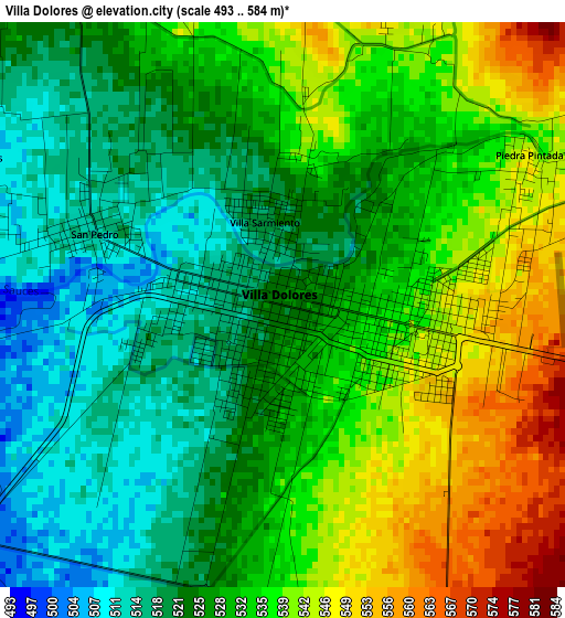
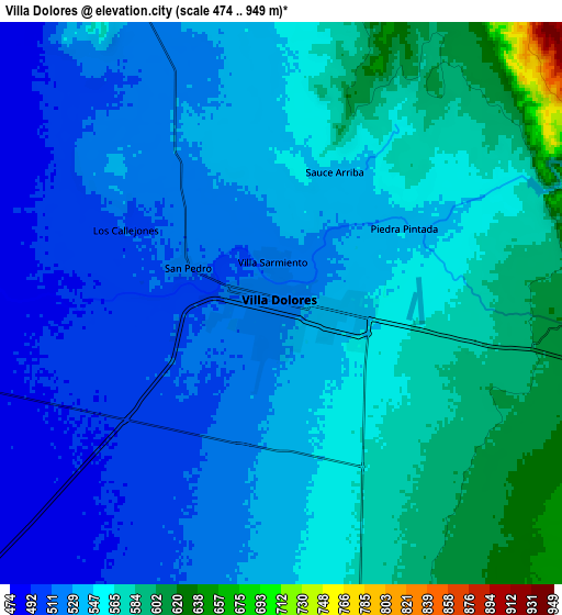
Below is the Elevation map of Villa Dolores, which displays elevation range with different colors. Scale of the first map is from 493 to 584 m (1617 to 1916 ft) with average elevation of 529.8 meters (=1738 ft) [note 1]
These maps also provides idea of topography and contour of this city, they are displayed at different zoom levels. More info about maps, scale and edge coordinates you can find below images.
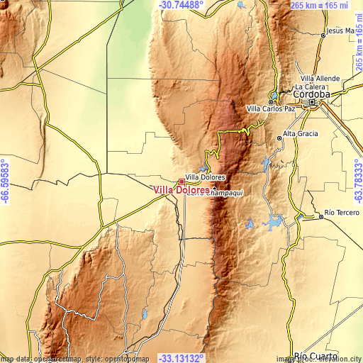
| \ | Map #1 | Map #2 | Topo.Map |
| Scale [m] | 493..584 m | 474..949 m | × |
| Scale [ft] | 1617..1916 ft | 1555..3114 ft | × |
| Average | 529.8 m = 1738 ft | 545.6 m = 1790 ft | × |
| Width | 8.29 km = 5.2 mi | 16.58 km = 10.3 mi | 265.3 km = 164.8 mi |
| Height | 8.29 km = 5.2 mi | 16.58 km = 10.3 mi | 265.4 km = 164.9 mi |
| ↑Max Latitude | -31.908553° | -31.87124° | -30.74488° |
| Latitude at center | -31.94585° | -31.94585° | -31.94585° |
| ↓Min Latitude | -31.983132° | -32.020399° | -33.13132° |
| ← Min Longitude | -65.233525° | -65.277471° | -66.59583° |
| Longitude center | -65.18958° | -65.18958° | -65.18958° |
| →Max Longitude | -65.145635° | -65.101689° | -63.78333° |
Nearby cities:
Cities around Villa Dolores sort by population:
• Merlo elevation 863 m
47.1 km,  159°
159°
• Santa Rosa de Calamuchita 598 m
63.1 km,  102°
102°
• Mina Clavero 895 m
30.4 km,  34°
34°
• Villa General Belgrano 742 m
59.9 km,  93°
93°
• Villa Berna 1373 m
43.3 km, 85°
• Villa Cura Brochero 909 m
31.2 km, 31°
• Concarán 673 m
68.5 km,  184°
184°
• Santa Rosa del Conlara 591 m
44.2 km, 181°
• Villa Las Rosas 744 m
12.8 km, 92°
• Candelaria 410 m
61.2 km,  257°
257°
• Salsacate 927 m
70.4 km,  7°
7°
• Libertador General San Martín 944 m
69 km,  221°
221°
Multilingual:
 En español:
Villa Dolores elevación 523 m.
 En France:
Villa Dolores élévation 523 m.
 Auf Deutsch:
Villa Dolores höhe über dem Meeresspiegel ist 523 m.

Sources and notes:
- [note 1] Map square and city borders are not equal. Map elevation data is calculated only from area inside that square.
- [src 1] Elevation data from geonames database provided with same terms of usage.
- [src 2] The elevation map of Villa Dolores is generated using elevation data from NASA's 3 arcsec (90m) resolution SRTM data.
- [src 3] Base (background) map © OpenStreetMap contributors tiles are generated by Geofabrik and OpenTopoMap.
Copyright & License:
This Villa Dolores Elevation Map is licensed under CC BY-SA. You may reuse any part from this page, if you give a proper credit by linking to this URL:
 More info on terms of use page.