Río Segundo elevation
Río Segundo (Cordoba, Departamento de Río Segundo), Argentina elevation is 341 meters and Río Segundo elevation in feet is 1119 ft above sea level [src 1]. Río Segundo is a populated place (feature code) with elevation that is 9 meters (30 ft) smaller than average city elevation in Argentina.
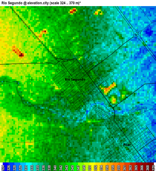
Below is the Elevation map of Río Segundo, which displays elevation range with different colors. Scale of the first map is from 324 to 370 m (1063 to 1214 ft) with average elevation of 339.6 meters (=1114 ft) [note 1]
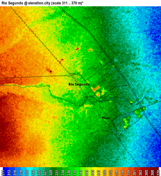
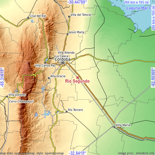
These maps also provides idea of topography and contour of this city, they are displayed at different zoom levels. More info about maps, scale and edge coordinates you can find below images.
| \ | Map #1 | Map #2 | Topo.Map |
| Scale [m] | 324..370 m | 311..370 m | × |
| Scale [ft] | 1063..1214 ft | 1020..1214 ft | × |
| Average | 339.6 m = 1114 ft | 337.9 m = 1109 ft | × |
| Width | 8.32 km = 5.2 mi | 16.64 km = 10.3 mi | 266.2 km = 165.4 mi |
| Height | 8.32 km = 5.2 mi | 16.64 km = 10.3 mi | 266.2 km = 165.4 mi |
| ↑Max Latitude | -31.615184° | -31.577753° | -30.44788° |
| Latitude at center | -31.6526° | -31.6526° | -31.6526° |
| ↓Min Latitude | -31.690001° | -31.727386° | -32.8419° |
| ← Min Longitude | -63.953845° | -63.997791° | -65.31615° |
| Longitude center | -63.9099° | -63.9099° | -63.9099° |
| →Max Longitude | -63.865955° | -63.822009° | -62.50365° |
Nearby cities:
Cities around Río Segundo sort by population:
• Córdoba elevation 395 m
37 km,  315°
315°
• Oncativo 283 m
36.1 km,  143°
143°
• Pilar 334 m
4.1 km, 135°
• Malagueño 568 m
47.4 km,  296°
296°
• Malvinas Argentinas 397 m
33.1 km,  335°
335°
• Laguna Larga 308 m
17.2 km, 143°
• Monte Cristo 350 m
34.6 km,  354°
354°
• Despeñaderos 451 m
40.3 km,  243°
243°
• Toledo 371 m
14.3 km, 318°
• Costa Sacate 308 m
14.3 km,  87°
87°
• Piquillín 285 m
41.6 km,  20°
20°
• Villa del Rosario 249 m
37.1 km,  73°
73°
Multilingual:
 En español:
Río Segundo elevación 341 m.
 En France:
Río Segundo élévation 341 m.
 Auf Deutsch:
Río Segundo höhe über dem Meeresspiegel ist 341 m.

Sources and notes:
- [note 1] Map square and city borders are not equal. Map elevation data is calculated only from area inside that square.
- [src 1] Elevation data from geonames database provided with same terms of usage.
- [src 2] The elevation map of Río Segundo is generated using elevation data from NASA's 3 arcsec (90m) resolution SRTM data.
- [src 3] Base (background) map © OpenStreetMap contributors tiles are generated by Geofabrik and OpenTopoMap.
Copyright & License:
This Río Segundo Elevation Map is licensed under CC BY-SA. You may reuse any part from this page, if you give a proper credit by linking to this URL:
 More info on terms of use page.