San Luis elevation
San Luis, Argentina elevation is 729 meters and San Luis elevation in feet is 2392 ft above sea level [src 1]. San Luis is a seat of a first-order administrative division (feature code) with elevation that is 379 meters (1243 ft) bigger than average city elevation in Argentina.
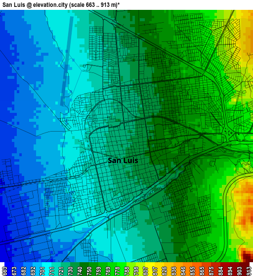
Below is the Elevation map of San Luis, which displays elevation range with different colors. Scale of the first map is from 663 to 913 m (2175 to 2995 ft) with average elevation of 731 meters (=2398 ft) [note 1]
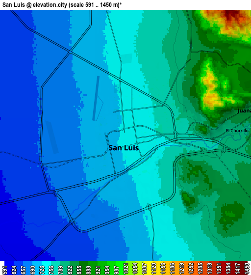
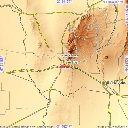
These maps also provides idea of topography and contour of this city, they are displayed at different zoom levels. More info about maps, scale and edge coordinates you can find below images.
| \ | Map #1 | Map #2 | Topo.Map |
| Scale [m] | 663..913 m | 591..1450 m | × |
| Scale [ft] | 2175..2995 ft | 1939..4757 ft | × |
| Average | 731 m = 2398 ft | 744.4 m = 2442 ft | × |
| Width | 8.17 km = 5.1 mi | 16.34 km = 10.2 mi | 261.4 km = 162.4 mi |
| Height | 8.17 km = 5.1 mi | 16.34 km = 10.2 mi | 261.4 km = 162.4 mi |
| ↑Max Latitude | -33.25827° | -33.221515° | -32.11172° |
| Latitude at center | -33.29501° | -33.29501° | -33.29501° |
| ↓Min Latitude | -33.331734° | -33.368443° | -34.46247° |
| ← Min Longitude | -66.379575° | -66.423521° | -67.74188° |
| Longitude center | -66.33563° | -66.33563° | -66.33563° |
| →Max Longitude | -66.291685° | -66.247739° | -64.92938° |
Nearby cities:
Cities around San Luis sort by population:
• Villa Mercedes elevation 516 m
91.8 km,  117°
117°
• La Punta 814 m
12.6 km,  9°
9°
• Justo Daract 421 m
123.9 km, 120°
• La Toma 897 m
71.5 km,  67°
67°
• Tilisarao 752 m
115.7 km,  57°
57°
• San Francisco del Monte de Oro 792 m
79.9 km, 14°
• Naschel 867 m
98.8 km, 64°
• Achiras 832 m
125.5 km,  83°
83°
• Luján 616 m
109.7 km,  19°
19°
• Villa General Roca 650 m
70.8 km,  351°
351°
• Libertador General San Martín 944 m
116 km,  32°
32°
• La Paz 510 m
114.2 km,  260°
260°
Multilingual:
 En español:
San Luis elevación 729 m.
 En France:
San Luis élévation 729 m.
 Auf Deutsch:
San Luis höhe über dem Meeresspiegel ist 729 m.

Sources and notes:
- [note 1] Map square and city borders are not equal. Map elevation data is calculated only from area inside that square.
- [src 1] Elevation data from geonames database provided with same terms of usage.
- [src 2] The elevation map of San Luis is generated using elevation data from NASA's 3 arcsec (90m) resolution SRTM data.
- [src 3] Base (background) map © OpenStreetMap contributors tiles are generated by Geofabrik and OpenTopoMap.
Copyright & License:
This San Luis Elevation Map is licensed under CC BY-SA. You may reuse any part from this page, if you give a proper credit by linking to this URL:
 More info on terms of use page.