Trancas elevation
Trancas (Tucuman, Departamento de Trancas), Argentina elevation is 780 meters and Trancas elevation in feet is 2559 ft above sea level [src 1]. Trancas is a seat of a second-order administrative division (feature code) with elevation that is 430 meters (1411 ft) bigger than average city elevation in Argentina.
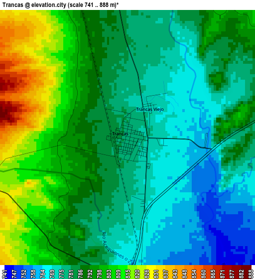
Below is the Elevation map of Trancas, which displays elevation range with different colors. Scale of the first map is from 741 to 888 m (2431 to 2913 ft) with average elevation of 788.3 meters (=2586 ft) [note 1]
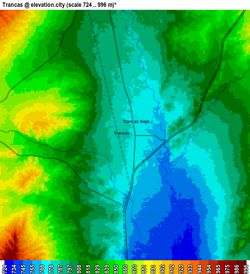
These maps also provides idea of topography and contour of this city, they are displayed at different zoom levels. More info about maps, scale and edge coordinates you can find below images.
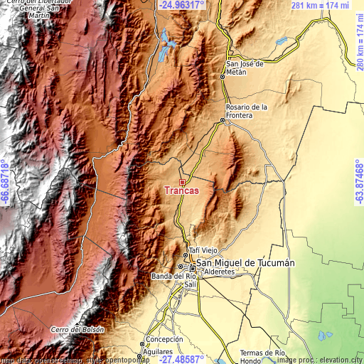
| \ | Map #1 | Map #2 | Topo.Map |
| Scale [m] | 741..888 m | 724..996 m | × |
| Scale [ft] | 2431..2913 ft | 2375..3268 ft | × |
| Average | 788.3 m = 2586 ft | 812 m = 2664 ft | × |
| Width | 8.77 km = 5.4 mi | 17.53 km = 10.9 mi | 280.5 km = 174.3 mi |
| Height | 8.77 km = 5.4 mi | 17.53 km = 10.9 mi | 280.5 km = 174.3 mi |
| ↑Max Latitude | -26.191934° | -26.152494° | -24.96317° |
| Latitude at center | -26.23136° | -26.23136° | -26.23136° |
| ↓Min Latitude | -26.270773° | -26.310173° | -27.48587° |
| ← Min Longitude | -65.324875° | -65.368821° | -66.68718° |
| Longitude center | -65.28093° | -65.28093° | -65.28093° |
| →Max Longitude | -65.236985° | -65.193039° | -63.87468° |
Nearby cities:
Cities around Trancas sort by population:
• San Miguel de Tucumán elevation 452 m
66.2 km,  174°
174°
• Yerba Buena 515 m
65.2 km,  183°
183°
• Tafí Viejo 629 m
55.7 km, 177°
• Alderetes 454 m
66.7 km, 167°
• Cafayate 1625 m
71.7 km,  284°
284°
• Tafí del Valle 2000 m
81.2 km,  211°
211°
• Burruyacú 526 m
61.4 km,  119°
119°
• San Isidro de Lules 418 m
77.6 km, 184°
• San Carlos 1630 m
75.3 km,  300°
300°
• Banda del Río Salí 431 m
67.9 km, 170°
• Rosario de la Frontera 787 m
57.4 km,  32°
32°
• La Candelaria 1042 m
25.8 km,  63°
63°
Multilingual:
 En español:
Trancas elevación 780 m.
 En France:
Trancas élévation 780 m.


Sources and notes:
- [note 1] Map square and city borders are not equal. Map elevation data is calculated only from area inside that square.
- [src 1] Elevation data from geonames database provided with same terms of usage.
- [src 2] The elevation map of Trancas is generated using elevation data from NASA's 3 arcsec (90m) resolution SRTM data.
- [src 3] Base (background) map © OpenStreetMap contributors tiles are generated by Geofabrik and OpenTopoMap.
Copyright & License:
This Trancas Elevation Map is licensed under CC BY-SA. You may reuse any part from this page, if you give a proper credit by linking to this URL:
 More info on terms of use page.