Victoria elevation
Victoria (Entre Rios, Departamento de Victoria), Argentina elevation is 52 meters and Victoria elevation in feet is 171 ft above sea level [src 1]. Victoria is a populated place (feature code) with elevation that is 298 meters (978 ft) smaller than average city elevation in Argentina.
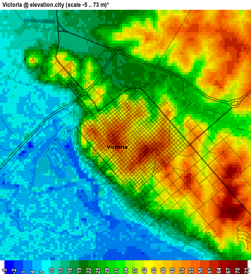
Below is the Elevation map of Victoria, which displays elevation range with different colors. Scale of the first map is from -5 to 73 m (-16 to 240 ft) with average elevation of 26.9 meters (=88 ft) [note 1]
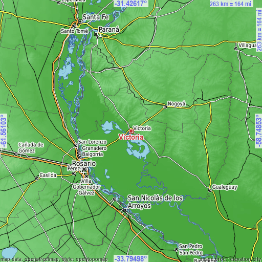
These maps also provides idea of topography and contour of this city, they are displayed at different zoom levels. More info about maps, scale and edge coordinates you can find below images.
| \ | Map #1 | Map #2 | Topo.Map |
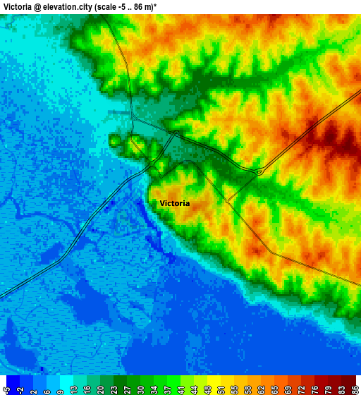
| Scale [m] | -5..73 m | -5..86 m | × |
| Scale [ft] | -16..240 ft | -16..282 ft | × |
| Average | 26.9 m = 88 ft | 25.4 m = 83 ft | × |
| Width | 8.23 km = 5.1 mi | 16.46 km = 10.2 mi | 263.4 km = 163.7 mi |
| Height | 8.23 km = 5.1 mi | 16.46 km = 10.2 mi | 263.4 km = 163.7 mi |
| ↑Max Latitude | -32.581388° | -32.544351° | -31.42617° |
| Latitude at center | -32.61841° | -32.61841° | -32.61841° |
| ↓Min Latitude | -32.655417° | -32.692408° | -33.79498° |
| ← Min Longitude | -60.198725° | -60.242671° | -61.56103° |
| Longitude center | -60.15478° | -60.15478° | -60.15478° |
| →Max Longitude | -60.110835° | -60.066889° | -58.74853° |
Nearby cities:
Cities around Victoria sort by population:
• Rosario elevation 38 m
58.2 km,  231°
231°
• Gobernador Gálvez 28 m
64.5 km,  224°
224°
• Granadero Baigorria 32 m
58.9 km,  243°
243°
• Capitán Bermúdez 35 m
57.4 km,  246°
246°
• Crespo 109 m
67.1 km,  347°
347°
• Fray Luis A. Beltrán 30 m
57 km, 250°
• General Ramírez 117 m
49.4 km, 354°
• Lucas González 94 m
64.1 km,  66°
66°
• Hernández 100 m
33.7 km,  21°
21°
• Aranguren 114 m
41.8 km,  359°
359°
• San Lorenzo 30 m
56.2 km,  255°
255°
• Nogoyá 50 m
42.4 km,  53°
53°
Multilingual:
 En español:
Victoria elevación 52 m.
 En France:
Victoria élévation 52 m.


Sources and notes:
- [note 1] Map square and city borders are not equal. Map elevation data is calculated only from area inside that square.
- [src 1] Elevation data from geonames database provided with same terms of usage.
- [src 2] The elevation map of Victoria is generated using elevation data from NASA's 3 arcsec (90m) resolution SRTM data.
- [src 3] Base (background) map © OpenStreetMap contributors tiles are generated by Geofabrik and OpenTopoMap.
Copyright & License:
This Victoria Elevation Map is licensed under CC BY-SA. You may reuse any part from this page, if you give a proper credit by linking to this URL:
 More info on terms of use page.