Perugorría elevation
Perugorría (Corrientes, Departamento de Curuzú Cuatiá), Argentina elevation is 64 meters and Perugorría elevation in feet is 210 ft above sea level [src 1]. Perugorría is a populated place (feature code) with elevation that is 286 meters (938 ft) smaller than average city elevation in Argentina.
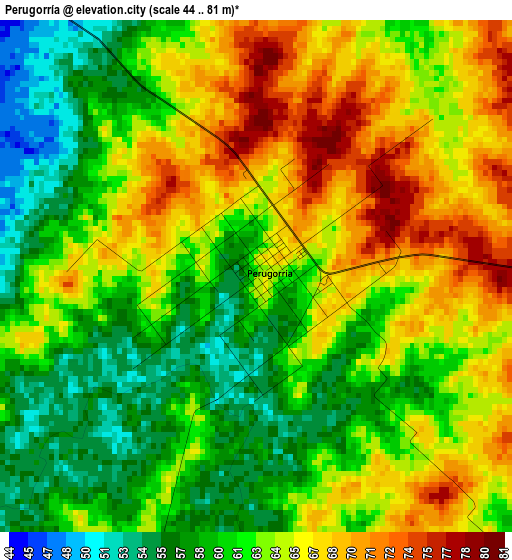
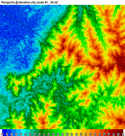
Below is the Elevation map of Perugorría, which displays elevation range with different colors. Scale of the first map is from 44 to 81 m (144 to 266 ft) with average elevation of 63 meters (=207 ft) [note 1]
These maps also provides idea of topography and contour of this city, they are displayed at different zoom levels. More info about maps, scale and edge coordinates you can find below images.
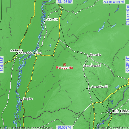
| \ | Map #1 | Map #2 | Topo.Map |
| Scale [m] | 44..81 m | 43..84 m | × |
| Scale [ft] | 144..266 ft | 141..276 ft | × |
| Average | 63 m = 207 ft | 60.9 m = 200 ft | × |
| Width | 8.52 km = 5.3 mi | 17.04 km = 10.6 mi | 272.6 km = 169.4 mi |
| Height | 8.52 km = 5.3 mi | 17.04 km = 10.6 mi | 272.6 km = 169.4 mi |
| ↑Max Latitude | -29.303005° | -29.264676° | -28.10816° |
| Latitude at center | -29.34132° | -29.34132° | -29.34132° |
| ↓Min Latitude | -29.379621° | -29.417907° | -30.55974° |
| ← Min Longitude | -58.654535° | -58.698481° | -60.01684° |
| Longitude center | -58.61059° | -58.61059° | -58.61059° |
| →Max Longitude | -58.566645° | -58.522699° | -57.20434° |
Nearby cities:
Cities around Perugorría sort by population:
• Goya elevation 25 m
67.2 km,  289°
289°
• Curuzú Cuatiá 79 m
73.5 km,  132°
132°
• Mercedes 96 m
54.8 km,  71°
71°
• Santa Lucía 54 m
61.9 km,  309°
309°
• Gobernador Juan E. Martínez 64 m
57.3 km,  326°
326°
• Nueve de Julio 74 m
59.5 km,  339°
339°
• Chavarría 64 m
43.1 km,  4°
4°
• Yataity Calle 72 m
46 km,  321°
321°
• Pedro R. Fernández 73 m
65.8 km,  356°
356°
• Mariano I. Loza 122 m
40.5 km,  95°
95°
• Felipe Yofré 72 m
37.5 km,  44°
44°
• Cruz de los Milagros 59 m
68 km, 325°
Multilingual:
 En español:
Perugorría elevación 64 m.
 En France:
Perugorría élévation 64 m.
 Auf Deutsch:
Perugorría höhe über dem Meeresspiegel ist 64 m.

Sources and notes:
- [note 1] Map square and city borders are not equal. Map elevation data is calculated only from area inside that square.
- [src 1] Elevation data from geonames database provided with same terms of usage.
- [src 2] The elevation map of Perugorría is generated using elevation data from NASA's 3 arcsec (90m) resolution SRTM data.
- [src 3] Base (background) map © OpenStreetMap contributors tiles are generated by Geofabrik and OpenTopoMap.
Copyright & License:
This Perugorría Elevation Map is licensed under CC BY-SA. You may reuse any part from this page, if you give a proper credit by linking to this URL:
 More info on terms of use page.