Santa Lucía elevation
Santa Lucía (Corrientes, Departamento de Lavalle), Argentina elevation is 54 meters and Santa Lucía elevation in feet is 177 ft above sea level [src 1]. Santa Lucía is a seat of a second-order administrative division (feature code) with elevation that is 296 meters (971 ft) smaller than average city elevation in Argentina.
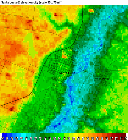
Below is the Elevation map of Santa Lucía, which displays elevation range with different colors. Scale of the first map is from 35 to 75 m (115 to 246 ft) with average elevation of 53.3 meters (=175 ft) [note 1]
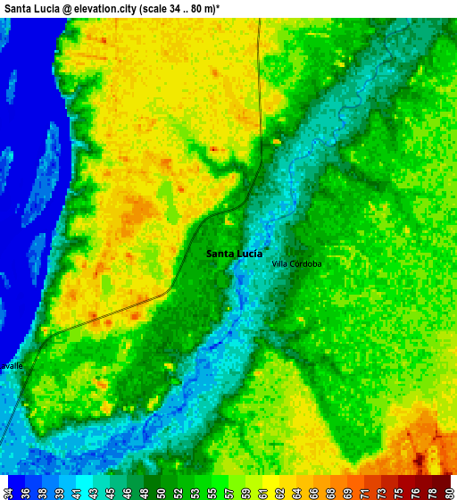
These maps also provides idea of topography and contour of this city, they are displayed at different zoom levels. More info about maps, scale and edge coordinates you can find below images.
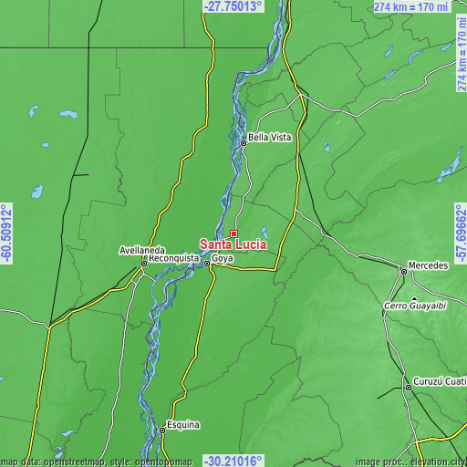
| \ | Map #1 | Map #2 | Topo.Map |
| Scale [m] | 35..75 m | 34..80 m | × |
| Scale [ft] | 115..246 ft | 112..262 ft | × |
| Average | 53.3 m = 175 ft | 52.8 m = 173 ft | × |
| Width | 8.55 km = 5.3 mi | 17.1 km = 10.6 mi | 273.5 km = 169.9 mi |
| Height | 8.55 km = 5.3 mi | 17.1 km = 10.6 mi | 273.5 km = 169.9 mi |
| ↑Max Latitude | -28.949013° | -28.910551° | -27.75013° |
| Latitude at center | -28.98746° | -28.98746° | -28.98746° |
| ↓Min Latitude | -29.025893° | -29.064312° | -30.21016° |
| ← Min Longitude | -59.146815° | -59.190761° | -60.50912° |
| Longitude center | -59.10287° | -59.10287° | -59.10287° |
| →Max Longitude | -59.058925° | -59.014979° | -57.69662° |
Nearby cities:
Cities around Santa Lucía sort by population:
• Reconquista elevation 50 m
56.2 km,  251°
251°
• Goya 25 m
23 km,  222°
222°
• Avellaneda 52 m
55.9 km, 254°
• Villa Ocampo 54 m
60.8 km,  336°
336°
• Gobernador Juan E. Martínez 64 m
18.3 km,  62°
62°
• Nueve de Julio 74 m
31.5 km, 58°
• Chavarría 64 m
51.7 km,  85°
85°
• Yataity Calle 72 m
19.2 km,  100°
100°
• Pedro R. Fernández 73 m
50.9 km, 58°
• Cruz de los Milagros 59 m
19.3 km,  29°
29°
• San Roque 64 m
59.9 km,  39°
39°
• Bella Vista 63 m
53.7 km,  6°
6°
Multilingual:
 En español:
Santa Lucía elevación 54 m.
 En France:
Santa Lucía élévation 54 m.
 Auf Deutsch:
Santa Lucía höhe über dem Meeresspiegel ist 54 m.

Sources and notes:
- [note 1] Map square and city borders are not equal. Map elevation data is calculated only from area inside that square.
- [src 1] Elevation data from geonames database provided with same terms of usage.
- [src 2] The elevation map of Santa Lucía is generated using elevation data from NASA's 3 arcsec (90m) resolution SRTM data.
- [src 3] Base (background) map © OpenStreetMap contributors tiles are generated by Geofabrik and OpenTopoMap.
Copyright & License:
This Santa Lucía Elevation Map is licensed under CC BY-SA. You may reuse any part from this page, if you give a proper credit by linking to this URL:
 More info on terms of use page.