Pirané elevation
Pirané (Formosa, Departamento de Pirané), Argentina elevation is 86 meters and Pirané elevation in feet is 282 ft above sea level [src 1]. Pirané is a seat of a second-order administrative division (feature code) with elevation that is 264 meters (866 ft) smaller than average city elevation in Argentina.
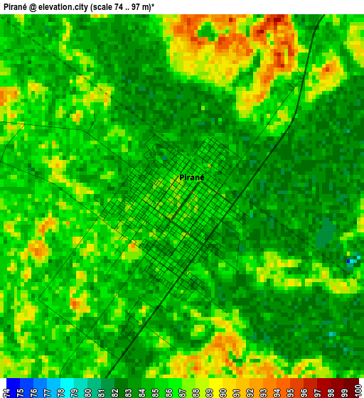
Below is the Elevation map of Pirané, which displays elevation range with different colors. Scale of the first map is from 74 to 97 m (243 to 318 ft) with average elevation of 85.1 meters (=279 ft) [note 1]
These maps also provides idea of topography and contour of this city, they are displayed at different zoom levels. More info about maps, scale and edge coordinates you can find below images.
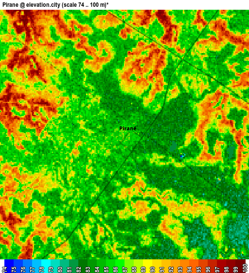
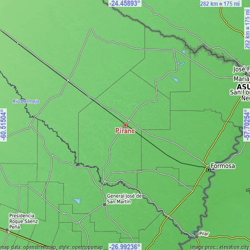
| \ | Map #1 | Map #2 | Topo.Map |
| Scale [m] | 74..97 m | 74..100 m | × |
| Scale [ft] | 243..318 ft | 243..328 ft | × |
| Average | 85.1 m = 279 ft | 87 m = 285 ft | × |
| Width | 8.8 km = 5.5 mi | 17.61 km = 10.9 mi | 281.7 km = 175 mi |
| Height | 8.8 km = 5.5 mi | 17.61 km = 10.9 mi | 281.7 km = 175 mi |
| ↑Max Latitude | -25.692796° | -25.653189° | -24.45893° |
| Latitude at center | -25.73239° | -25.73239° | -25.73239° |
| ↓Min Latitude | -25.771971° | -25.811538° | -26.99236° |
| ← Min Longitude | -59.152735° | -59.196681° | -60.51504° |
| Longitude center | -59.10879° | -59.10879° | -59.10879° |
| →Max Longitude | -59.064845° | -59.020899° | -57.70254° |
Nearby cities:
Cities around Pirané sort by population:
• Formosa elevation 62 m
106.2 km,  118°
118°
• General José de San Martín 81 m
92.5 km,  194°
194°
• El Colorado 86 m
69.2 km,  202°
202°
• Pampa del Indio 96 m
90.1 km,  246°
246°
• Ibarreta 107 m
94.8 km,  307°
307°
• Comandante Fontana 103 m
72.6 km, 307°
• Palo Santo 90 m
29.7 km, 309°
• Presidencia Roca 91 m
66.6 km,  226°
226°
• San Francisco de Laishí 73 m
74.2 km,  139°
139°
• Riacho Eh-Eh 78 m
93 km,  63°
63°
• Laguna Limpia 86 m
102.3 km,  213°
213°
• Espinillo 92 m
100.5 km,  33°
33°
Multilingual:
 En español:
Pirané elevación 86 m.
 En France:
Pirané élévation 86 m.


Sources and notes:
- [note 1] Map square and city borders are not equal. Map elevation data is calculated only from area inside that square.
- [src 1] Elevation data from geonames database provided with same terms of usage.
- [src 2] The elevation map of Pirané is generated using elevation data from NASA's 3 arcsec (90m) resolution SRTM data.
- [src 3] Base (background) map © OpenStreetMap contributors tiles are generated by Geofabrik and OpenTopoMap.
Copyright & License:
This Pirané Elevation Map is licensed under CC BY-SA. You may reuse any part from this page, if you give a proper credit by linking to this URL:
 More info on terms of use page.