Uíge elevation
Uíge, Angola elevation is 825 meters and Uíge elevation in feet is 2707 ft above sea level [src 1]. Uíge is a seat of a first-order administrative division (feature code) with elevation that is 144 meters (472 ft) smaller than average city elevation in Angola.
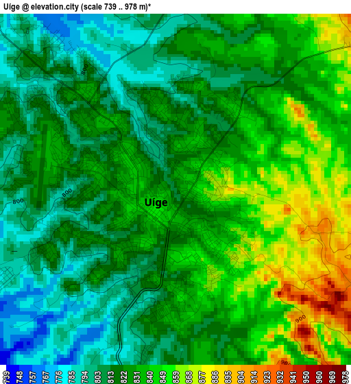
Below is the Elevation map of Uíge, which displays elevation range with different colors. Scale of the first map is from 739 to 978 m (2425 to 3209 ft) with average elevation of 827.2 meters (=2714 ft) [note 1]
These maps also provides idea of topography and contour of this city, they are displayed at different zoom levels. More info about maps, scale and edge coordinates you can find below images.
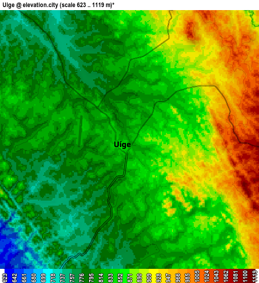
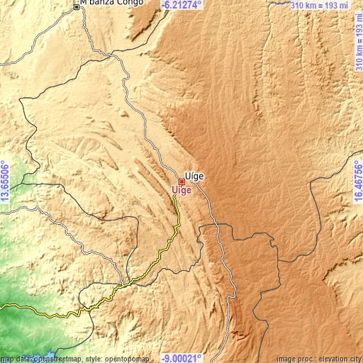
| \ | Map #1 | Map #2 | Topo.Map |
| Scale [m] | 739..978 m | 623..1119 m | × |
| Scale [ft] | 2425..3209 ft | 2044..3671 ft | × |
| Average | 827.2 m = 2714 ft | 840.9 m = 2759 ft | × |
| Width | 9.69 km = 6 mi | 19.37 km = 12 mi | 309.9 km = 192.6 mi |
| Height | 9.69 km = 6 mi | 19.37 km = 12 mi | 310 km = 192.6 mi |
| ↑Max Latitude | -7.565179° | -7.521614° | -6.21274° |
| Latitude at center | -7.60874° | -7.60874° | -7.60874° |
| ↓Min Latitude | -7.652296° | -7.695848° | -9.00021° |
| ← Min Longitude | 15.017365° | 14.973419° | 13.65506° |
| Longitude center | 15.06131° | 15.06131° | 15.06131° |
| →Max Longitude | 15.105255° | 15.149201° | 16.46756° |
Nearby cities:
Cities around Uíge sort by population:
• Luanda elevation 73 m
243 km,  235°
235°
• N’dalatando 795 m
188.5 km,  185°
185°
• Malanje 1134 m
256.7 km,  146°
146°
• Soio 10 m
339.4 km,  298°
298°
• Cabinda 1 m
390.2 km,  305°
305°
• Sumbe 10 m
421.7 km,  198°
198°
• Caxito 20 m
187.8 km,  234°
234°
• Mbanza Congo 544 m
174.6 km,  328°
328°
• N'zeto 19 m
245.6 km,  279°
279°
• Camabatela 1237 m
73.1 km, 151°
• Uacu Cungo 1304 m
416.8 km,  179°
179°
• Quibala 1284 m
347.6 km, 181°
Multilingual:
 En español:
Uíge elevación 825 m.
 En France:
Uíge élévation 825 m.


Sources and notes:
- [note 1] Map square and city borders are not equal. Map elevation data is calculated only from area inside that square.
- [src 1] Elevation data from geonames database provided with same terms of usage.
- [src 2] The elevation map of Uíge is generated using elevation data from NASA's 3 arcsec (90m) resolution SRTM data.
- [src 3] Base (background) map © OpenStreetMap contributors tiles are generated by Geofabrik and OpenTopoMap.
Copyright & License:
This Uíge Elevation Map is licensed under CC BY-SA. You may reuse any part from this page, if you give a proper credit by linking to this URL:
 More info on terms of use page.