Mrgavet elevation
Mrgavet (Ararat), Armenia elevation is 842 meters and Mrgavet elevation in feet is 2762 ft above sea level [src 1]. Mrgavet is a populated place (feature code) with elevation that is 456 meters (1496 ft) smaller than average city elevation in Armenia.
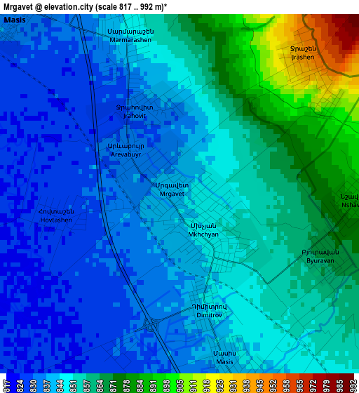
Below is the Elevation map of Mrgavet, which displays elevation range with different colors. Scale of the first map is from 817 to 992 m (2680 to 3255 ft) with average elevation of 849.8 meters (=2788 ft) [note 1]
These maps also provides idea of topography and contour of this city, they are displayed at different zoom levels. More info about maps, scale and edge coordinates you can find below images.
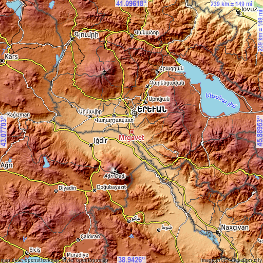
| \ | Map #1 | Topo.Map |
| Scale [m] | 817..992 m | × |
| Scale [ft] | 2680..3255 ft | × |
| Average | 849.8 m = 2788 ft | × |
| Width | 7.48 km = 4.6 mi | 239.5 km = 148.8 mi |
| Height | 7.48 km = 4.6 mi | 239.5 km = 148.8 mi |
| ↑Max Latitude | 40.061532° | 41.09618° |
| Latitude at center | 40.02789° | 40.02789° |
| ↓Min Latitude | 39.994231° | 38.9426° |
| ← Min Longitude | 44.439335° | 43.07703° |
| Longitude center | 44.48328° | 44.48328° |
| →Max Longitude | 44.527225° | 45.88953° |
Nearby cities:
Cities around Mrgavet sort by population:
• Marmarashen elevation 847 m
3.5 km,  344°
344°
• Arevshat 931 m
5.1 km,  75°
75°
• Burastan 839 m
4.2 km,  164°
164°
• Nshavan 886 m
3.6 km,  90°
90°
• Noramarg 829 m
5 km,  262°
262°
• Jrashen 941 m
3.7 km,  42°
42°
• Abovyan 956 m
5.9 km,  67°
67°
• Byuravan 868 m
3.3 km,  113°
113°
• Dimitrov 845 m
2.3 km, 161°
• Hovtashen 826 m
2.8 km, 263°
• Arevabuyr 834 m
1.5 km,  307°
307°
• Jrahovit 837 m
2.3 km, 342°
Multilingual:
 En español:
Mrgavet elevación 842 m.
 En France:
Mrgavet élévation 842 m.


Sources and notes:
- [note 1] Map square and city borders are not equal. Map elevation data is calculated only from area inside that square.
- [src 1] Elevation data from geonames database provided with same terms of usage.
- [src 2] The elevation map of Mrgavet is generated using elevation data from NASA's 3 arcsec (90m) resolution SRTM data.
- [src 3] Base (background) map © OpenStreetMap contributors tiles are generated by Geofabrik and OpenTopoMap.
Copyright & License:
This Mrgavet Elevation Map is licensed under CC BY-SA. You may reuse any part from this page, if you give a proper credit by linking to this URL:
 More info on terms of use page.