Burastan elevation
Burastan (Ararat), Armenia elevation is 839 meters and Burastan elevation in feet is 2753 ft above sea level [src 1]. Burastan is a populated place (feature code) with elevation that is 459 meters (1506 ft) smaller than average city elevation in Armenia.
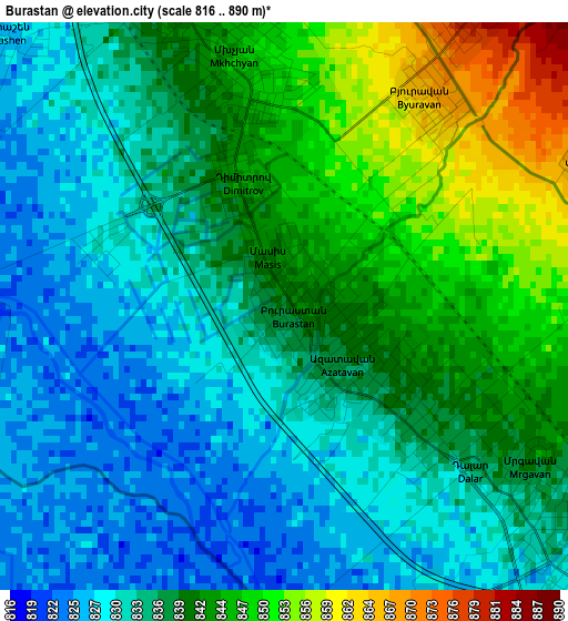
Below is the Elevation map of Burastan, which displays elevation range with different colors. Scale of the first map is from 816 to 890 m (2677 to 2920 ft) with average elevation of 837.5 meters (=2748 ft) [note 1]
These maps also provides idea of topography and contour of this city, they are displayed at different zoom levels. More info about maps, scale and edge coordinates you can find below images.
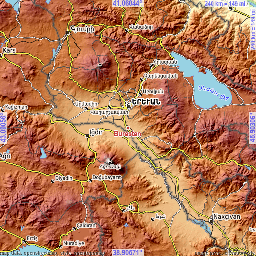
| \ | Map #1 | Topo.Map |
| Scale [m] | 816..890 m | × |
| Scale [ft] | 2677..2920 ft | × |
| Average | 837.5 m = 2748 ft | × |
| Width | 7.49 km = 4.7 mi | 239.6 km = 148.9 mi |
| Height | 7.49 km = 4.7 mi | 239.6 km = 148.9 mi |
| ↑Max Latitude | 40.02523° | 41.06044° |
| Latitude at center | 39.99157° | 39.99157° |
| ↓Min Latitude | 39.957893° | 38.90571° |
| ← Min Longitude | 44.452865° | 43.09056° |
| Longitude center | 44.49681° | 44.49681° |
| →Max Longitude | 44.540755° | 45.90306° |
Nearby cities:
Cities around Burastan sort by population:
• Artashat elevation 830 m
5.3 km,  129°
129°
• Vostan 837 m
6.1 km,  118°
118°
• Dalar 839 m
3 km, 123°
• Aygestan 869 m
5.4 km,  76°
76°
• Mrgavet 842 m
4.2 km,  344°
344°
• Nshavan 886 m
4.7 km,  31°
31°
• Mrgavan 840 m
3.9 km, 122°
• Berk’anush 836 m
2.3 km, 131°
• Byuravan 868 m
3.3 km, 34°
• Dimitrov 845 m
1.9 km,  346°
346°
• Hovtashen 826 m
5.5 km,  313°
313°
• Arevabuyr 834 m
5.5 km,  334°
334°
Multilingual:
 En español:
Burastan elevación 839 m.
 En France:
Burastan élévation 839 m.
 Auf Deutsch:
Burastan höhe über dem Meeresspiegel ist 839 m.

Sources and notes:
- [note 1] Map square and city borders are not equal. Map elevation data is calculated only from area inside that square.
- [src 1] Elevation data from geonames database provided with same terms of usage.
- [src 2] The elevation map of Burastan is generated using elevation data from NASA's 3 arcsec (90m) resolution SRTM data.
- [src 3] Base (background) map © OpenStreetMap contributors tiles are generated by Geofabrik and OpenTopoMap.
Copyright & License:
This Burastan Elevation Map is licensed under CC BY-SA. You may reuse any part from this page, if you give a proper credit by linking to this URL:
 More info on terms of use page.