Arteni elevation
Arteni (Aragatsotn), Armenia elevation is 1206 meters and Arteni elevation in feet is 3957 ft above sea level [src 1]. Arteni is a populated place (feature code) with elevation that is 92 meters (302 ft) smaller than average city elevation in Armenia.
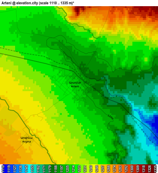
Below is the Elevation map of Arteni, which displays elevation range with different colors. Scale of the first map is from 1110 to 1335 m (3642 to 4380 ft) with average elevation of 1217.9 meters (=3996 ft) [note 1]
These maps also provides idea of topography and contour of this city, they are displayed at different zoom levels. More info about maps, scale and edge coordinates you can find below images.
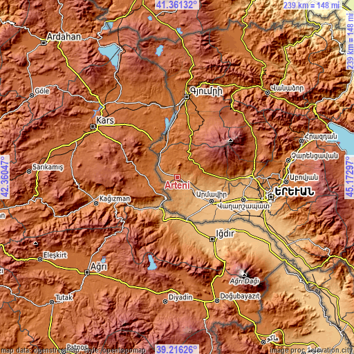
| \ | Map #1 | Topo.Map |
| Scale [m] | 1110..1335 m | × |
| Scale [ft] | 3642..4380 ft | × |
| Average | 1217.9 m = 3996 ft | × |
| Width | 7.45 km = 4.6 mi | 238.5 km = 148.2 mi |
| Height | 7.45 km = 4.6 mi | 238.5 km = 148.2 mi |
| ↑Max Latitude | 40.330809° | 41.36132° |
| Latitude at center | 40.2973° | 40.2973° |
| ↓Min Latitude | 40.263775° | 39.21626° |
| ← Min Longitude | 43.722775° | 42.36047° |
| Longitude center | 43.76672° | 43.76672° |
| →Max Longitude | 43.810665° | 45.17297° |
Nearby cities:
Cities around Arteni sort by population:
• Armavir elevation 870 m
28 km,  124°
124°
• Sardarapat 862 m
27.6 km,  131°
131°
• T’alin 1631 m
14.1 km,  41°
41°
• Myasnikyan 906 m
18.4 km,  135°
135°
• Bambakashat 865 m
30 km, 134°
• Dalarik 1005 m
12.2 km, 129°
• Lukashin 874 m
23.6 km, 121°
• Shenavan 896 m
30.3 km,  152°
152°
• Agarakavan 1445 m
26.2 km,  81°
81°
• Lenughi 887 m
25.4 km, 138°
• Dzit’hank’ov 1751 m
23.9 km,  11°
11°
• Ashnak 1429 m
13.2 km,  73°
73°
Multilingual:
 En español:
Arteni elevación 1206 m.
 En France:
Arteni élévation 1206 m.


Sources and notes:
- [note 1] Map square and city borders are not equal. Map elevation data is calculated only from area inside that square.
- [src 1] Elevation data from geonames database provided with same terms of usage.
- [src 2] The elevation map of Arteni is generated using elevation data from NASA's 3 arcsec (90m) resolution SRTM data.
- [src 3] Base (background) map © OpenStreetMap contributors tiles are generated by Geofabrik and OpenTopoMap.
Copyright & License:
This Arteni Elevation Map is licensed under CC BY-SA. You may reuse any part from this page, if you give a proper credit by linking to this URL:
 More info on terms of use page.