Byurakan elevation
Byurakan (Aragatsotn), Armenia elevation is 1489 meters and Byurakan elevation in feet is 4885 ft above sea level [src 1]. Byurakan is a populated place (feature code) with elevation that is 191 meters (627 ft) bigger than average city elevation in Armenia.
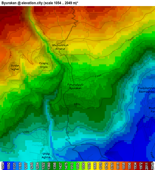
Below is the Elevation map of Byurakan, which displays elevation range with different colors. Scale of the first map is from 1054 to 2049 m (3458 to 6722 ft) with average elevation of 1467.6 meters (=4815 ft) [note 1]
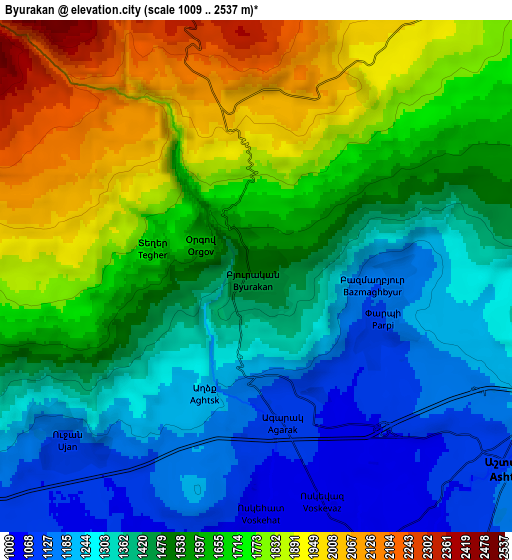
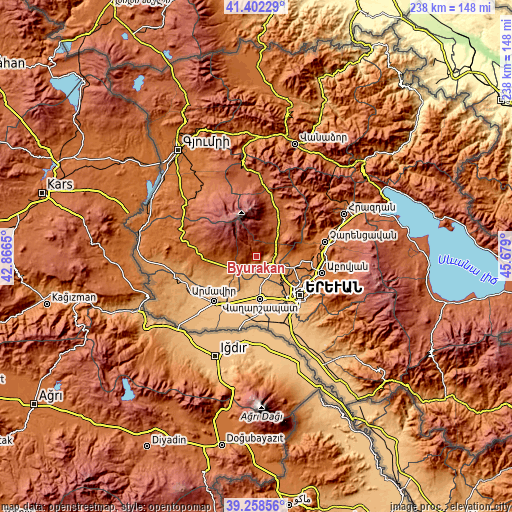
These maps also provides idea of topography and contour of this city, they are displayed at different zoom levels. More info about maps, scale and edge coordinates you can find below images.
| \ | Map #1 | Map #2 | Topo.Map |
| Scale [m] | 1054..2049 m | 1009..2537 m | × |
| Scale [ft] | 3458..6722 ft | 3310..8323 ft | × |
| Average | 1467.6 m = 4815 ft | 1536.2 m = 5040 ft | × |
| Width | 7.45 km = 4.6 mi | 14.9 km = 9.3 mi | 238.4 km = 148.1 mi |
| Height | 7.45 km = 4.6 mi | 14.9 km = 9.3 mi | 238.4 km = 148.1 mi |
| ↑Max Latitude | 40.372428° | 40.405899° | 41.40229° |
| Latitude at center | 40.33894° | 40.33894° | 40.33894° |
| ↓Min Latitude | 40.305435° | 40.271914° | 39.25856° |
| ← Min Longitude | 44.228805° | 44.184859° | 42.8665° |
| Longitude center | 44.27275° | 44.27275° | 44.27275° |
| →Max Longitude | 44.316695° | 44.360641° | 45.679° |
Nearby cities:
Cities around Byurakan sort by population:
• Ashtarak elevation 1142 m
8.8 km,  120°
120°
• Oshakan 1051 m
9.1 km,  155°
155°
• Voskevaz 1042 m
7.5 km, 161°
• Karbi 1305 m
9 km,  95°
95°
• Aghavnatun 931 m
11.9 km,  188°
188°
• Kosh 1205 m
10.4 km,  245°
245°
• Sasunik 1071 m
11.6 km,  148°
148°
• Nor Yerznka 1193 m
10.8 km,  113°
113°
• Aygeshat 942 m
11.5 km,  173°
173°
• Ushi 1394 m
8.7 km,  83°
83°
• Gmbet’ 917 m
12.9 km, 187°
• Doghs 926 m
13 km,  180°
180°
Multilingual:
 En español:
Byurakan elevación 1489 m.
 En France:
Byurakan élévation 1489 m.
 Auf Deutsch:
Byurakan höhe über dem Meeresspiegel ist 1489 m.

Sources and notes:
- [note 1] Map square and city borders are not equal. Map elevation data is calculated only from area inside that square.
- [src 1] Elevation data from geonames database provided with same terms of usage.
- [src 2] The elevation map of Byurakan is generated using elevation data from NASA's 3 arcsec (90m) resolution SRTM data.
- [src 3] Base (background) map © OpenStreetMap contributors tiles are generated by Geofabrik and OpenTopoMap.
Copyright & License:
This Byurakan Elevation Map is licensed under CC BY-SA. You may reuse any part from this page, if you give a proper credit by linking to this URL:
 More info on terms of use page.