Oshakan elevation
Oshakan (Aragatsotn), Armenia elevation is 1051 meters and Oshakan elevation in feet is 3448 ft above sea level [src 1]. Oshakan is a populated place (feature code) with elevation that is 247 meters (810 ft) smaller than average city elevation in Armenia.
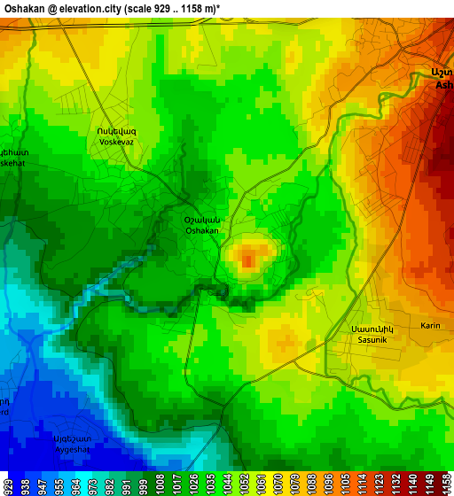
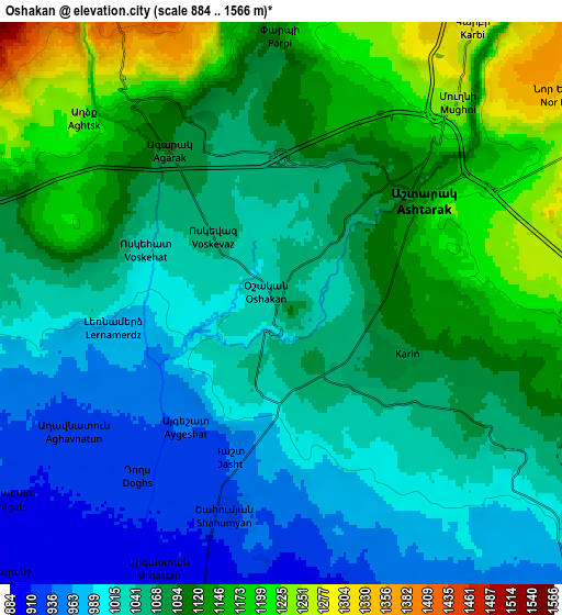
Below is the Elevation map of Oshakan, which displays elevation range with different colors. Scale of the first map is from 929 to 1158 m (3048 to 3799 ft) with average elevation of 1039.9 meters (=3412 ft) [note 1]
These maps also provides idea of topography and contour of this city, they are displayed at different zoom levels. More info about maps, scale and edge coordinates you can find below images.
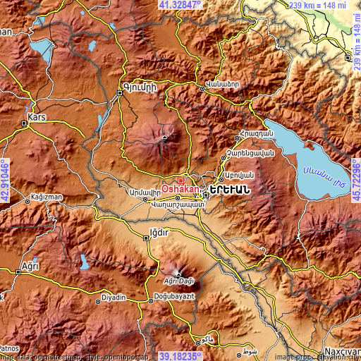
| \ | Map #1 | Map #2 | Topo.Map |
| Scale [m] | 929..1158 m | 884..1566 m | × |
| Scale [ft] | 3048..3799 ft | 2900..5138 ft | × |
| Average | 1039.9 m = 3412 ft | 1074 m = 3524 ft | × |
| Width | 7.46 km = 4.6 mi | 14.91 km = 9.3 mi | 238.6 km = 148.3 mi |
| Height | 7.46 km = 4.6 mi | 14.91 km = 9.3 mi | 238.6 km = 148.3 mi |
| ↑Max Latitude | 40.297445° | 40.330954° | 41.32847° |
| Latitude at center | 40.26392° | 40.26392° | 40.26392° |
| ↓Min Latitude | 40.230378° | 40.19682° | 39.18235° |
| ← Min Longitude | 44.272765° | 44.228819° | 42.91046° |
| Longitude center | 44.31671° | 44.31671° | 44.31671° |
| →Max Longitude | 44.360655° | 44.404601° | 45.72296° |
Nearby cities:
Cities around Oshakan sort by population:
• Ashtarak elevation 1142 m
5.5 km,  44°
44°
• Prroshyan 1185 m
8.9 km,  101°
101°
• Voskevaz 1042 m
1.9 km,  311°
311°
• Karbi 1305 m
9.1 km,  34°
34°
• Aghavnatun 931 m
6.4 km,  237°
237°
• Norakert 942 m
7.9 km,  159°
159°
• Baghramyan 947 m
8.9 km,  149°
149°
• Sasunik 1071 m
2.8 km,  123°
123°
• Nor Yerznka 1193 m
7.3 km,  56°
56°
• Aygeshat 942 m
3.9 km,  217°
217°
• Gmbet’ 917 m
6.9 km,  229°
229°
• Doghs 926 m
6 km, 219°
Multilingual:
 En español:
Oshakan elevación 1051 m.
 En France:
Ochakan élévation 1051 m.
 Auf Deutsch:
Oschakan höhe über dem Meeresspiegel ist 1051 m.

Sources and notes:
- [note 1] Map square and city borders are not equal. Map elevation data is calculated only from area inside that square.
- [src 1] Elevation data from geonames database provided with same terms of usage.
- [src 2] The elevation map of Oshakan is generated using elevation data from NASA's 3 arcsec (90m) resolution SRTM data.
- [src 3] Base (background) map © OpenStreetMap contributors tiles are generated by Geofabrik and OpenTopoMap.
Copyright & License:
This Oshakan Elevation Map is licensed under CC BY-SA. You may reuse any part from this page, if you give a proper credit by linking to this URL:
 More info on terms of use page.