Vanadzor elevation
Vanadzor (Lori), Armenia elevation is 1344 meters and Vanadzor elevation in feet is 4409 ft above sea level [src 1]. Vanadzor is a seat of a first-order administrative division (feature code) with elevation that is 46 meters (151 ft) bigger than average city elevation in Armenia.
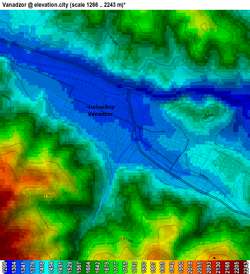
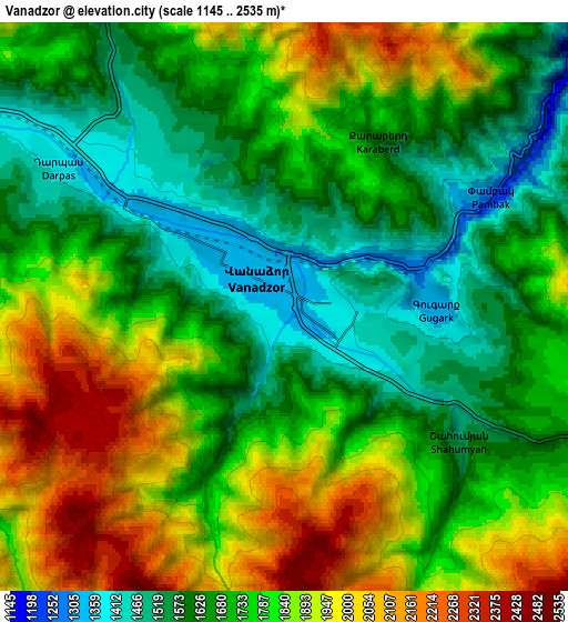
Below is the Elevation map of Vanadzor, which displays elevation range with different colors. Scale of the first map is from 1266 to 2243 m (4154 to 7359 ft) with average elevation of 1553.6 meters (=5097 ft) [note 1]
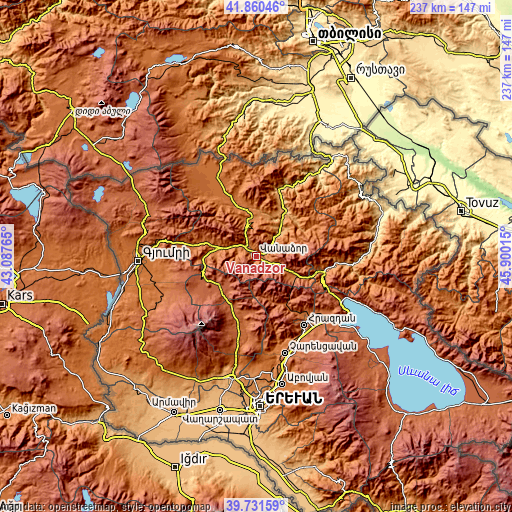
These maps also provides idea of topography and contour of this city, they are displayed at different zoom levels. More info about maps, scale and edge coordinates you can find below images.
| \ | Map #1 | Map #2 | Topo.Map |
| Scale [m] | 1266..2243 m | 1145..2535 m | × |
| Scale [ft] | 4154..7359 ft | 3757..8317 ft | × |
| Average | 1553.6 m = 5097 ft | 1759.3 m = 5772 ft | × |
| Width | 7.4 km = 4.6 mi | 14.79 km = 9.2 mi | 236.7 km = 147.1 mi |
| Height | 7.4 km = 4.6 mi | 14.79 km = 9.2 mi | 236.7 km = 147.1 mi |
| ↑Max Latitude | 40.837816° | 40.871055° | 41.86046° |
| Latitude at center | 40.80456° | 40.80456° | 40.80456° |
| ↓Min Latitude | 40.771288° | 40.737998° | 39.73159° |
| ← Min Longitude | 44.449955° | 44.406009° | 43.08765° |
| Longitude center | 44.4939° | 44.4939° | 44.4939° |
| →Max Longitude | 44.537845° | 44.581791° | 45.90015° |
Nearby cities:
Cities around Vanadzor sort by population:
• Spitak elevation 1548 m
19.3 km,  279°
279°
• Gugark’ 1320 m
3.9 km,  89°
89°
• Margahovit 1752 m
17.9 km,  116°
116°
• Gyulagarak 1366 m
18.2 km,  354°
354°
• Shahumyan 1520 m
5.5 km,  127°
127°
• Darpas 1377 m
6.8 km,  301°
301°
• Lerrnapat 1524 m
8.5 km, 278°
• Vardablur 1318 m
18.5 km,  3°
3°
• Lerrnants’k’ 1667 m
18.5 km,  266°
266°
• Vahagni 1076 m
14.9 km,  40°
40°
• Yeghegnut 1096 m
15.9 km,  46°
46°
• Bazum 1521 m
8.4 km,  327°
327°
Multilingual:
 En español:
Vanadzor elevación 1344 m.
 En France:
Vanadzor élévation 1344 m.
 Auf Deutsch:
Wanadsor höhe über dem Meeresspiegel ist 1344 m.
 На русском:
Кировакан, Ванадзор высота над уровнем моря 1344 м
Sources and notes:
- [note 1] Map square and city borders are not equal. Map elevation data is calculated only from area inside that square.
- [src 1] Elevation data from geonames database provided with same terms of usage.
- [src 2] The elevation map of Vanadzor is generated using elevation data from NASA's 3 arcsec (90m) resolution SRTM data.
- [src 3] Base (background) map © OpenStreetMap contributors tiles are generated by Geofabrik and OpenTopoMap.
Copyright & License:
This Vanadzor Elevation Map is licensed under CC BY-SA. You may reuse any part from this page, if you give a proper credit by linking to this URL:
 More info on terms of use page.