Spitak elevation
Spitak (Lori), Armenia elevation is 1548 meters and Spitak elevation in feet is 5079 ft above sea level [src 1]. Spitak is a populated place (feature code) with elevation that is 250 meters (820 ft) bigger than average city elevation in Armenia.
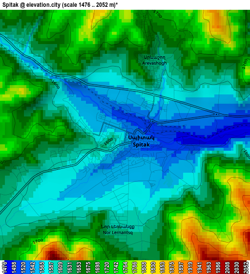
Below is the Elevation map of Spitak, which displays elevation range with different colors. Scale of the first map is from 1476 to 2052 m (4843 to 6732 ft) with average elevation of 1646.5 meters (=5402 ft) [note 1]
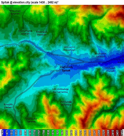
These maps also provides idea of topography and contour of this city, they are displayed at different zoom levels. More info about maps, scale and edge coordinates you can find below images.
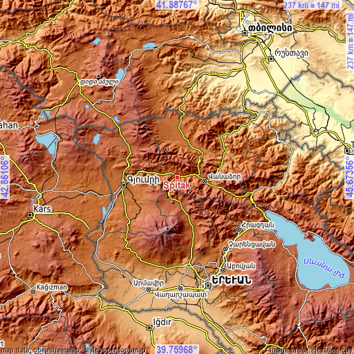
| \ | Map #1 | Map #2 | Topo.Map |
| Scale [m] | 1476..2052 m | 1430..2492 m | × |
| Scale [ft] | 4843..6732 ft | 4692..8176 ft | × |
| Average | 1646.5 m = 5402 ft | 1816.2 m = 5959 ft | × |
| Width | 7.39 km = 4.6 mi | 14.79 km = 9.2 mi | 236.6 km = 147 mi |
| Height | 7.39 km = 4.6 mi | 14.79 km = 9.2 mi | 236.6 km = 147 mi |
| ↑Max Latitude | 40.865452° | 40.898677° | 41.88767° |
| Latitude at center | 40.83221° | 40.83221° | 40.83221° |
| ↓Min Latitude | 40.798951° | 40.765676° | 39.75968° |
| ← Min Longitude | 44.223365° | 44.179419° | 42.86106° |
| Longitude center | 44.26731° | 44.26731° | 44.26731° |
| →Max Longitude | 44.311255° | 44.355201° | 45.67356° |
Nearby cities:
Cities around Spitak sort by population:
• Jrashen elevation 1676 m
8.2 km,  235°
235°
• Arevashogh 1680 m
3.2 km,  10°
10°
• Shirakamut 1766 m
10.1 km,  288°
288°
• Mets Parni 1697 m
13.1 km,  271°
271°
• Darpas 1377 m
13.3 km,  87°
87°
• Lerrnapat 1524 m
10.8 km,  100°
100°
• Lerrnavan 1778 m
10.3 km, 241°
• Sarahart’ 1733 m
6.2 km,  313°
313°
• Tsaghkaber 1762 m
14.5 km,  254°
254°
• Lerrnants’k’ 1667 m
4.1 km,  171°
171°
• Saramej 1780 m
7.4 km,  210°
210°
• Gogaran 1849 m
8.8 km,  319°
319°
Multilingual:
 En español:
Spitak elevación 1548 m.
 En France:
Spitak élévation 1548 m.


Sources and notes:
- [note 1] Map square and city borders are not equal. Map elevation data is calculated only from area inside that square.
- [src 1] Elevation data from geonames database provided with same terms of usage.
- [src 2] The elevation map of Spitak is generated using elevation data from NASA's 3 arcsec (90m) resolution SRTM data.
- [src 3] Base (background) map © OpenStreetMap contributors tiles are generated by Geofabrik and OpenTopoMap.
Copyright & License:
This Spitak Elevation Map is licensed under CC BY-SA. You may reuse any part from this page, if you give a proper credit by linking to this URL:
 More info on terms of use page.