Maralik elevation
Maralik (Shirak), Armenia elevation is 1713 meters and Maralik elevation in feet is 5620 ft above sea level [src 1]. Maralik is a populated place (feature code) with elevation that is 415 meters (1362 ft) bigger than average city elevation in Armenia.
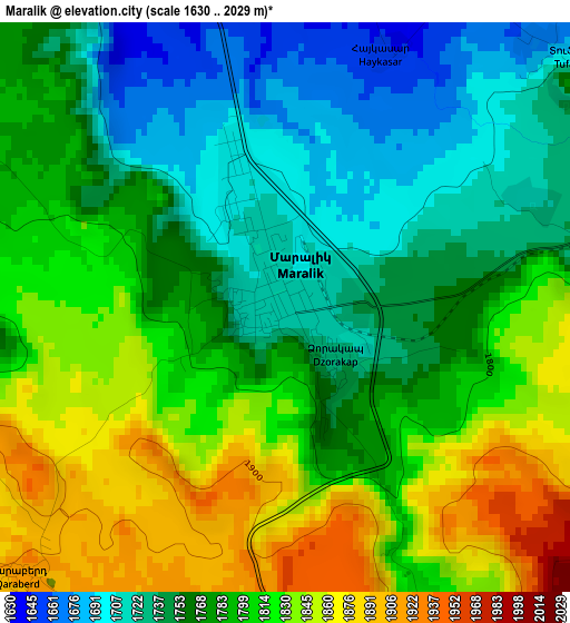
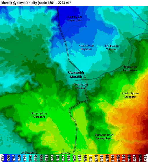
Below is the Elevation map of Maralik, which displays elevation range with different colors. Scale of the first map is from 1630 to 2029 m (5348 to 6657 ft) with average elevation of 1786.2 meters (=5860 ft) [note 1]
These maps also provides idea of topography and contour of this city, they are displayed at different zoom levels. More info about maps, scale and edge coordinates you can find below images.
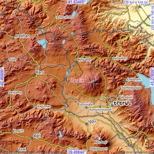
| \ | Map #1 | Map #2 | Topo.Map |
| Scale [m] | 1630..2029 m | 1561..2293 m | × |
| Scale [ft] | 5348..6657 ft | 5121..7523 ft | × |
| Average | 1786.2 m = 5860 ft | 1811.7 m = 5944 ft | × |
| Width | 7.42 km = 4.6 mi | 14.85 km = 9.2 mi | 237.5 km = 147.6 mi |
| Height | 7.42 km = 4.6 mi | 14.85 km = 9.2 mi | 237.5 km = 147.6 mi |
| ↑Max Latitude | 40.608441° | 40.641794° | 41.63465° |
| Latitude at center | 40.57507° | 40.57507° | 40.57507° |
| ↓Min Latitude | 40.541683° | 40.508279° | 39.49844° |
| ← Min Longitude | 43.828365° | 43.784419° | 42.46606° |
| Longitude center | 43.87231° | 43.87231° | 43.87231° |
| →Max Longitude | 43.916255° | 43.960201° | 45.27856° |
Nearby cities:
Cities around Maralik sort by population:
• Azatan elevation 1498 m
16.5 km,  346°
346°
• Pemzashen 1803 m
6.1 km,  78°
78°
• Horrom 1578 m
9.5 km,  9°
9°
• P’ok’r Mant’ash 1977 m
16.4 km,  63°
63°
• Arevshat 1913 m
16.9 km, 59°
• Anushavan 1722 m
12.4 km,  47°
47°
• Lerrnakert 1984 m
5.8 km,  103°
103°
• Yerazgavors 1452 m
17 km,  321°
321°
• Spandaryan 1825 m
15.4 km, 51°
• Dzit’hank’ov 1751 m
8.6 km,  210°
210°
• Saratak 1561 m
10.7 km,  0°
0°
• Meghrashen 1664 m
13 km,  33°
33°
Multilingual:
 En español:
Maralik elevación 1713 m.
 En France:
Maralik élévation 1713 m.
 Auf Deutsch:
Maralik höhe über dem Meeresspiegel ist 1713 m.

Sources and notes:
- [note 1] Map square and city borders are not equal. Map elevation data is calculated only from area inside that square.
- [src 1] Elevation data from geonames database provided with same terms of usage.
- [src 2] The elevation map of Maralik is generated using elevation data from NASA's 3 arcsec (90m) resolution SRTM data.
- [src 3] Base (background) map © OpenStreetMap contributors tiles are generated by Geofabrik and OpenTopoMap.
Copyright & License:
This Maralik Elevation Map is licensed under CC BY-SA. You may reuse any part from this page, if you give a proper credit by linking to this URL:
 More info on terms of use page.