Azatan elevation
Azatan (Shirak), Armenia elevation is 1498 meters and Azatan elevation in feet is 4915 ft above sea level [src 1]. Azatan is a populated place (feature code) with elevation that is 200 meters (656 ft) bigger than average city elevation in Armenia.
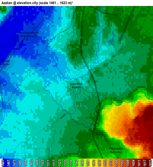
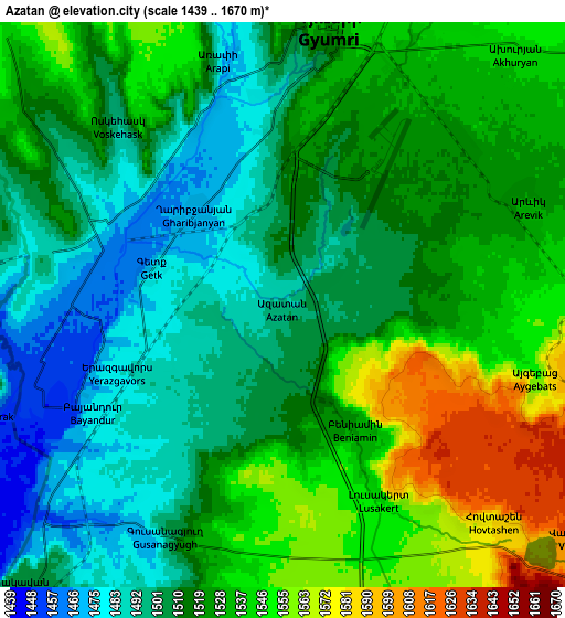
Below is the Elevation map of Azatan, which displays elevation range with different colors. Scale of the first map is from 1461 to 1623 m (4793 to 5325 ft) with average elevation of 1505.9 meters (=4941 ft) [note 1]
These maps also provides idea of topography and contour of this city, they are displayed at different zoom levels. More info about maps, scale and edge coordinates you can find below images.
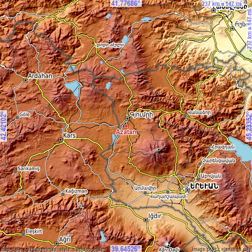
| \ | Map #1 | Map #2 | Topo.Map |
| Scale [m] | 1461..1623 m | 1439..1670 m | × |
| Scale [ft] | 4793..5325 ft | 4721..5479 ft | × |
| Average | 1505.9 m = 4941 ft | 1520.2 m = 4988 ft | × |
| Width | 7.41 km = 4.6 mi | 14.81 km = 9.2 mi | 237 km = 147.3 mi |
| Height | 7.41 km = 4.6 mi | 14.81 km = 9.2 mi | 237 km = 147.3 mi |
| ↑Max Latitude | 40.752888° | 40.78617° | 41.77686° |
| Latitude at center | 40.71959° | 40.71959° | 40.71959° |
| ↓Min Latitude | 40.686275° | 40.652943° | 39.64526° |
| ← Min Longitude | 43.783325° | 43.739379° | 42.42102° |
| Longitude center | 43.82727° | 43.82727° | 43.82727° |
| →Max Longitude | 43.871215° | 43.915161° | 45.23352° |
Nearby cities:
Cities around Azatan sort by population:
• Gyumri elevation 1549 m
8.4 km,  10°
10°
• Akhuryan 1544 m
9.1 km,  42°
42°
• Horrom 1578 m
8.5 km,  141°
141°
• Voskehask 1495 m
6.7 km,  318°
318°
• Arrap’i 1487 m
7.3 km,  345°
345°
• Marmashen 1619 m
13.5 km,  342°
342°
• Arevik 1532 m
6.9 km,  69°
69°
• Mayisyan 1642 m
14.2 km,  4°
4°
• Yerazgavors 1452 m
7.3 km,  247°
247°
• Haykavan 1557 m
11.3 km,  325°
325°
• Saratak 1561 m
6.6 km, 144°
• Meghrashen 1664 m
12.2 km,  115°
115°
Multilingual:
 En español:
Azatan elevación 1498 m.
 En France:
Azatan élévation 1498 m.


Sources and notes:
- [note 1] Map square and city borders are not equal. Map elevation data is calculated only from area inside that square.
- [src 1] Elevation data from geonames database provided with same terms of usage.
- [src 2] The elevation map of Azatan is generated using elevation data from NASA's 3 arcsec (90m) resolution SRTM data.
- [src 3] Base (background) map © OpenStreetMap contributors tiles are generated by Geofabrik and OpenTopoMap.
Copyright & License:
This Azatan Elevation Map is licensed under CC BY-SA. You may reuse any part from this page, if you give a proper credit by linking to this URL:
 More info on terms of use page.