Masis elevation
Masis (Ararat), Armenia elevation is 833 meters and Masis elevation in feet is 2733 ft above sea level [src 1]. Masis is a populated place (feature code) with elevation that is 465 meters (1526 ft) smaller than average city elevation in Armenia.
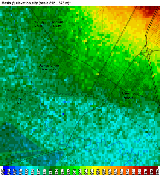
Below is the Elevation map of Masis, which displays elevation range with different colors. Scale of the first map is from 812 to 875 m (2664 to 2871 ft) with average elevation of 833.2 meters (=2734 ft) [note 1]
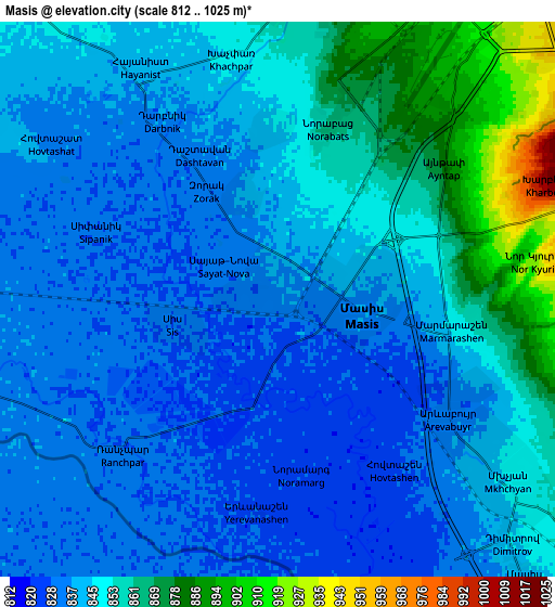
These maps also provides idea of topography and contour of this city, they are displayed at different zoom levels. More info about maps, scale and edge coordinates you can find below images.
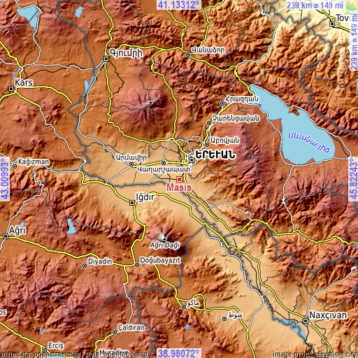
| \ | Map #1 | Map #2 | Topo.Map |
| Scale [m] | 812..875 m | 812..1025 m | × |
| Scale [ft] | 2664..2871 ft | 2664..3363 ft | × |
| Average | 833.2 m = 2734 ft | 846.3 m = 2777 ft | × |
| Width | 7.48 km = 4.6 mi | 14.96 km = 9.3 mi | 239.3 km = 148.7 mi |
| Height | 7.48 km = 4.6 mi | 14.96 km = 9.3 mi | 239.3 km = 148.7 mi |
| ↑Max Latitude | 40.099043° | 40.13265° | 41.13312° |
| Latitude at center | 40.06542° | 40.06542° | 40.06542° |
| ↓Min Latitude | 40.03178° | 39.998123° | 38.98072° |
| ← Min Longitude | 44.372235° | 44.328289° | 43.00993° |
| Longitude center | 44.41618° | 44.41618° | 44.41618° |
| →Max Longitude | 44.460125° | 44.504071° | 45.82243° |
Nearby cities:
Cities around Masis sort by population:
• Marmarashen elevation 847 m
4.8 km,  99°
99°
• Darakert 844 m
4.5 km,  357°
357°
• Norabats’ 864 m
4.7 km,  18°
18°
• Noramarg 829 m
4.9 km,  170°
170°
• Dashtavan 836 m
4.4 km,  331°
331°
• Sayat’-Nova 833 m
1.7 km,  308°
308°
• Zorak 835 m
3.5 km, 327°
• Sis 829 m
2.5 km,  251°
251°
• Hovtashen 826 m
5.3 km,  147°
147°
• Nizami 838 m
3.1 km,  343°
343°
• Arevabuyr 834 m
5.6 km,  125°
125°
• Jrahovit 837 m
5.4 km,  111°
111°
Multilingual:
 En español:
Masis elevación 833 m.
 En France:
Masis élévation 833 m.


Sources and notes:
- [note 1] Map square and city borders are not equal. Map elevation data is calculated only from area inside that square.
- [src 1] Elevation data from geonames database provided with same terms of usage.
- [src 2] The elevation map of Masis is generated using elevation data from NASA's 3 arcsec (90m) resolution SRTM data.
- [src 3] Base (background) map © OpenStreetMap contributors tiles are generated by Geofabrik and OpenTopoMap.
Copyright & License:
This Masis Elevation Map is licensed under CC BY-SA. You may reuse any part from this page, if you give a proper credit by linking to this URL:
 More info on terms of use page.