Zorak elevation
Zorak (Ararat), Armenia elevation is 835 meters and Zorak elevation in feet is 2740 ft above sea level [src 1]. Zorak is a populated place (feature code) with elevation that is 463 meters (1519 ft) smaller than average city elevation in Armenia.
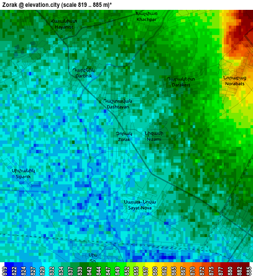
Below is the Elevation map of Zorak, which displays elevation range with different colors. Scale of the first map is from 819 to 885 m (2687 to 2904 ft) with average elevation of 836.9 meters (=2746 ft) [note 1]
These maps also provides idea of topography and contour of this city, they are displayed at different zoom levels. More info about maps, scale and edge coordinates you can find below images.
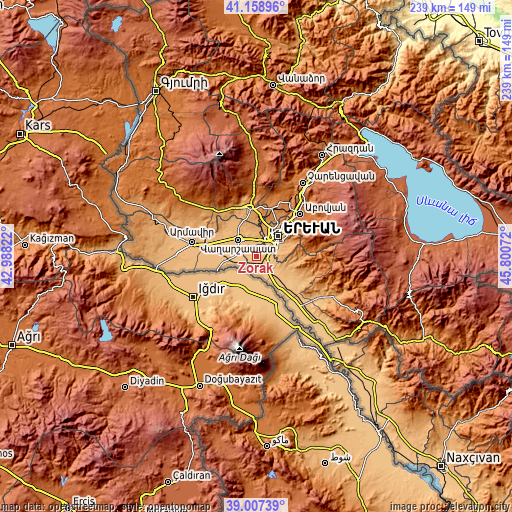
| \ | Map #1 | Topo.Map |
| Scale [m] | 819..885 m | × |
| Scale [ft] | 2687..2904 ft | × |
| Average | 836.9 m = 2746 ft | × |
| Width | 7.48 km = 4.6 mi | 239.2 km = 148.6 mi |
| Height | 7.48 km = 4.6 mi | 239.2 km = 148.6 mi |
| ↑Max Latitude | 40.125291° | 41.15896° |
| Latitude at center | 40.09168° | 40.09168° |
| ↓Min Latitude | 40.058053° | 39.00739° |
| ← Min Longitude | 44.350525° | 42.98822° |
| Longitude center | 44.39447° | 44.39447° |
| →Max Longitude | 44.438415° | 45.80072° |
Nearby cities:
Cities around Zorak sort by population:
• Masis elevation 833 m
3.5 km,  147°
147°
• Hovtashat 836 m
4.3 km,  278°
278°
• Darakert 844 m
2.3 km,  46°
46°
• Ghukasavan 851 m
4.5 km,  25°
25°
• Hayanist 843 m
3.7 km,  337°
337°
• Norabats’ 864 m
3.6 km,  64°
64°
• Arbat’ 856 m
5.3 km,  7°
7°
• Dashtavan 836 m
1 km,  345°
345°
• Sayat’-Nova 833 m
1.9 km,  165°
165°
• Arevashat 853 m
6.1 km, 344°
• Sis 829 m
3.7 km,  187°
187°
• Nizami 838 m
1 km,  90°
90°
Multilingual:
 En español:
Zorak elevación 835 m.
 En France:
Zorak élévation 835 m.


Sources and notes:
- [note 1] Map square and city borders are not equal. Map elevation data is calculated only from area inside that square.
- [src 1] Elevation data from geonames database provided with same terms of usage.
- [src 2] The elevation map of Zorak is generated using elevation data from NASA's 3 arcsec (90m) resolution SRTM data.
- [src 3] Base (background) map © OpenStreetMap contributors tiles are generated by Geofabrik and OpenTopoMap.
Copyright & License:
This Zorak Elevation Map is licensed under CC BY-SA. You may reuse any part from this page, if you give a proper credit by linking to this URL:
 More info on terms of use page.