Moglicë elevation
Moglicë (Korçë, Rrethi i Korçës), Albania elevation is 1112 meters and Moglicë elevation in feet is 3648 ft above sea level [src 1]. Moglicë is a seat of a third-order administrative division (feature code) with elevation that is 738 meters (2421 ft) bigger than average city elevation in Albania.
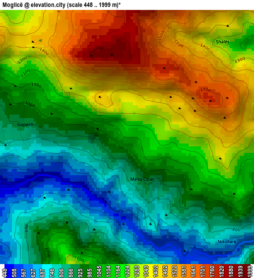
Below is the Elevation map of Moglicë, which displays elevation range with different colors. Scale of the first map is from 448 to 1999 m (1470 to 6558 ft) with average elevation of 1124.1 meters (=3688 ft) [note 1]
These maps also provides idea of topography and contour of this city, they are displayed at different zoom levels. More info about maps, scale and edge coordinates you can find below images.
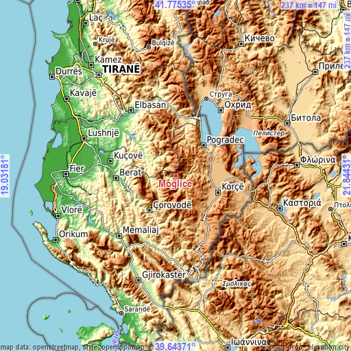
| \ | Map #1 | Topo.Map |
| Scale [m] | 448..1999 m | × |
| Scale [ft] | 1470..6558 ft | × |
| Average | 1124.1 m = 3688 ft | × |
| Width | 7.41 km = 4.6 mi | 237 km = 147.3 mi |
| Height | 7.41 km = 4.6 mi | 237 km = 147.3 mi |
| ↑Max Latitude | 40.751359° | 41.77535° |
| Latitude at center | 40.71806° | 40.71806° |
| ↓Min Latitude | 40.684744° | 39.64371° |
| ← Min Longitude | 20.394115° | 19.03181° |
| Longitude center | 20.43806° | 20.43806° |
| →Max Longitude | 20.482005° | 21.84431° |
Nearby cities:
Cities around Moglicë sort by population:
• Maliq elevation 844 m
22.1 km,  93°
93°
• Leshnjë 1098 m
22.7 km,  207°
207°
• Kushovë 306 m
22.4 km,  290°
290°
• Novoselë 936 m
22.4 km,  77°
77°
• Gjerbës 821 m
18.6 km,  237°
237°
• Kodovjat 276 m
18.5 km,  301°
301°
• Kukur 797 m
17.8 km,  339°
339°
• Skënderbegas 521 m
17.8 km, 291°
• Voskopojë 1199 m
15.8 km,  126°
126°
• Lekas 1010 m
14.3 km,  154°
154°
• Zhepë 801 m
13.5 km,  250°
250°
• Lenias 986 m
6.7 km,  323°
323°
Multilingual:
 En español:
Moglicë elevación 1112 m.
 En France:
Moglicë élévation 1112 m.
 Auf Deutsch:
Moglicë höhe über dem Meeresspiegel ist 1112 m.

Sources and notes:
- [note 1] Map square and city borders are not equal. Map elevation data is calculated only from area inside that square.
- [src 1] Elevation data from geonames database provided with same terms of usage.
- [src 2] The elevation map of Moglicë is generated using elevation data from NASA's 3 arcsec (90m) resolution SRTM data.
- [src 3] Base (background) map © OpenStreetMap contributors tiles are generated by Geofabrik and OpenTopoMap.
Copyright & License:
This Moglicë Elevation Map is licensed under CC BY-SA. You may reuse any part from this page, if you give a proper credit by linking to this URL:
 More info on terms of use page.