Frashër elevation
Frashër (Gjirokastër, Rrethi i Përmetit), Albania elevation is 1013 meters and Frashër elevation in feet is 3323 ft above sea level [src 1]. Frashër is a seat of a third-order administrative division (feature code) with elevation that is 639 meters (2096 ft) bigger than average city elevation in Albania.
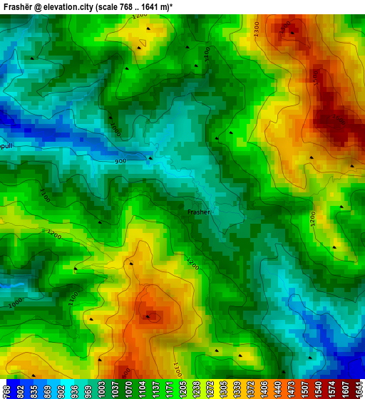
Below is the Elevation map of Frashër, which displays elevation range with different colors. Scale of the first map is from 768 to 1641 m (2520 to 5384 ft) with average elevation of 1138.9 meters (=3737 ft) [note 1]
These maps also provides idea of topography and contour of this city, they are displayed at different zoom levels. More info about maps, scale and edge coordinates you can find below images.
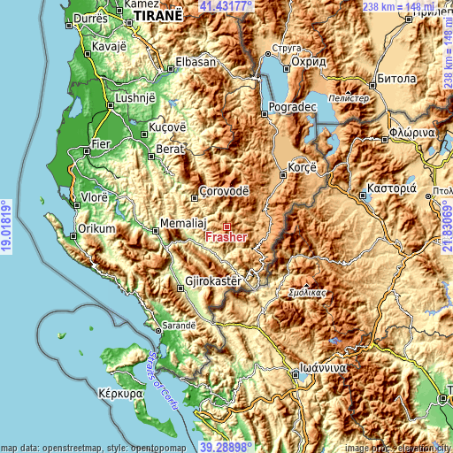
| \ | Map #1 | Topo.Map |
| Scale [m] | 768..1641 m | × |
| Scale [ft] | 2520..5384 ft | × |
| Average | 1138.9 m = 3737 ft | × |
| Width | 7.45 km = 4.6 mi | 238.3 km = 148.1 mi |
| Height | 7.45 km = 4.6 mi | 238.2 km = 148 mi |
| ↑Max Latitude | 40.402363° | 41.43177° |
| Latitude at center | 40.36889° | 40.36889° |
| ↓Min Latitude | 40.3354° | 39.28898° |
| ← Min Longitude | 20.380495° | 19.01819° |
| Longitude center | 20.42444° | 20.42444° |
| →Max Longitude | 20.468385° | 21.83069° |
Nearby cities:
Cities around Frashër sort by population:
• Përmet elevation 244 m
16.3 km,  202°
202°
• Ersekë 1021 m
21.8 km,  99°
99°
• Këlcyrë 178 m
20.9 km,  252°
252°
• Gjinkar 311 m
18.9 km,  184°
184°
• Leshnjë 1098 m
20.9 km,  333°
333°
• Barmash 879 m
19.3 km,  121°
121°
• Topojan 648 m
17.9 km,  272°
272°
• Petran 271 m
17.7 km, 181°
• Piskovë 202 m
16.3 km,  232°
232°
• Çepan 817 m
15 km,  292°
292°
• Potom 980 m
14 km,  341°
341°
• Çlirim 1148 m
11.9 km,  63°
63°
Multilingual:
 En español:
Frashër elevación 1013 m.
 En France:
Frashër élévation 1013 m.
 Auf Deutsch:
Frashër höhe über dem Meeresspiegel ist 1013 m.

Sources and notes:
- [note 1] Map square and city borders are not equal. Map elevation data is calculated only from area inside that square.
- [src 1] Elevation data from geonames database provided with same terms of usage.
- [src 2] The elevation map of Frashër is generated using elevation data from NASA's 3 arcsec (90m) resolution SRTM data.
- [src 3] Base (background) map © OpenStreetMap contributors tiles are generated by Geofabrik and OpenTopoMap.
Copyright & License:
This Frashër Elevation Map is licensed under CC BY-SA. You may reuse any part from this page, if you give a proper credit by linking to this URL:
 More info on terms of use page.