Petran elevation
Petran (Gjirokastër, Rrethi i Përmetit), Albania elevation is 271 meters and Petran elevation in feet is 889 ft above sea level [src 1]. Petran is a seat of a third-order administrative division (feature code) with elevation that is 103 meters (338 ft) smaller than average city elevation in Albania.
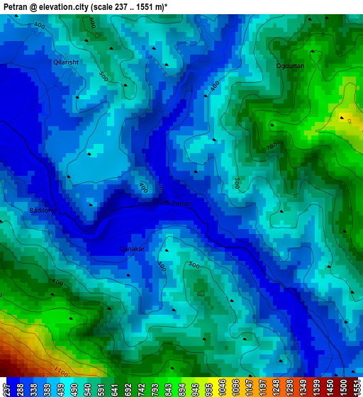
Below is the Elevation map of Petran, which displays elevation range with different colors. Scale of the first map is from 237 to 1551 m (778 to 5089 ft) with average elevation of 495.4 meters (=1625 ft) [note 1]
These maps also provides idea of topography and contour of this city, they are displayed at different zoom levels. More info about maps, scale and edge coordinates you can find below images.
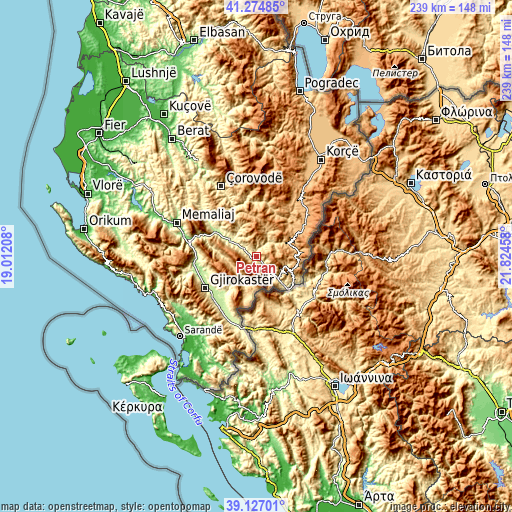
| \ | Map #1 | Topo.Map |
| Scale [m] | 237..1551 m | × |
| Scale [ft] | 778..5089 ft | × |
| Average | 495.4 m = 1625 ft | × |
| Width | 7.46 km = 4.6 mi | 238.8 km = 148.4 mi |
| Height | 7.46 km = 4.6 mi | 238.8 km = 148.4 mi |
| ↑Max Latitude | 40.242992° | 41.27485° |
| Latitude at center | 40.20944° | 40.20944° |
| ↓Min Latitude | 40.175871° | 39.12701° |
| ← Min Longitude | 20.374385° | 19.01208° |
| Longitude center | 20.41833° | 20.41833° |
| →Max Longitude | 20.462275° | 21.82458° |
Nearby cities:
Cities around Petran sort by population:
• Përmet elevation 244 m
6.3 km,  295°
295°
• Këlcyrë 178 m
22.6 km, 300°
• Gjinkar 311 m
1.5 km,  223°
223°
• Leskovik 909 m
16.5 km,  113°
113°
• Qestorat 553 m
21.2 km,  241°
241°
• Saraqinishtë 708 m
19.8 km,  234°
234°
• Barmash 879 m
18.6 km,  65°
65°
• Frashër 1013 m
17.7 km,  1°
1°
• Piskovë 202 m
14.6 km, 302°
• Çarshovë 328 m
14.5 km,  134°
134°
• Vithkuq 675 m
13.5 km,  267°
267°
• Skore 790 m
12.2 km,  201°
201°
Multilingual:
 En español:
Petran elevación 271 m.
 En France:
Petran élévation 271 m.


Sources and notes:
- [note 1] Map square and city borders are not equal. Map elevation data is calculated only from area inside that square.
- [src 1] Elevation data from geonames database provided with same terms of usage.
- [src 2] The elevation map of Petran is generated using elevation data from NASA's 3 arcsec (90m) resolution SRTM data.
- [src 3] Base (background) map © OpenStreetMap contributors tiles are generated by Geofabrik and OpenTopoMap.
Copyright & License:
This Petran Elevation Map is licensed under CC BY-SA. You may reuse any part from this page, if you give a proper credit by linking to this URL:
 More info on terms of use page.