Fushë-Bulqizë elevation
Fushë-Bulqizë (Dibër, Rrethi i Bulqizës), Albania elevation is 678 meters and Fushë-Bulqizë elevation in feet is 2224 ft above sea level [src 1]. Fushë-Bulqizë is a seat of a third-order administrative division (feature code) with elevation that is 304 meters (997 ft) bigger than average city elevation in Albania.
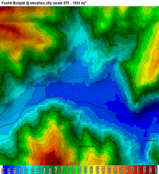
Below is the Elevation map of Fushë-Bulqizë, which displays elevation range with different colors. Scale of the first map is from 579 to 1933 m (1900 to 6342 ft) with average elevation of 1016.5 meters (=3335 ft) [note 1]
These maps also provides idea of topography and contour of this city, they are displayed at different zoom levels. More info about maps, scale and edge coordinates you can find below images.
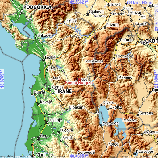
| \ | Map #1 | Topo.Map |
| Scale [m] | 579..1933 m | × |
| Scale [ft] | 1900..6342 ft | × |
| Average | 1016.5 m = 3335 ft | × |
| Width | 7.32 km = 4.5 mi | 234.1 km = 145.5 mi |
| Height | 7.32 km = 4.5 mi | 234.1 km = 145.5 mi |
| ↑Max Latitude | 41.554834° | 42.56623° |
| Latitude at center | 41.52194° | 41.52194° |
| ↓Min Latitude | 41.48903° | 40.46053° |
| ← Min Longitude | 20.238275° | 18.87597° |
| Longitude center | 20.28222° | 20.28222° |
| →Max Longitude | 20.326165° | 21.68847° |
Nearby cities:
Cities around Fushë-Bulqizë sort by population:
• Bulqizë elevation 775 m
6 km,  236°
236°
• Klos 257 m
16.4 km,  264°
264°
• Lis 491 m
20.2 km,  305°
305°
• Suç 281 m
20.2 km,  287°
287°
• Maqellarë 617 m
18.3 km,  65°
65°
• Fushë-Muhurr 411 m
18 km,  13°
13°
• Ostreni i Math 927 m
17.6 km,  125°
125°
• Martanesh 905 m
15.2 km,  206°
206°
• Gjorica e Sipërme 462 m
14 km,  84°
84°
• Shupenzë 499 m
11.8 km,  85°
85°
• Selishtë 743 m
11.7 km,  358°
358°
• Zerqan 725 m
6.9 km,  108°
108°
Multilingual:
 En español:
Fushë-Bulqizë elevación 678 m.
 En France:
Fushë-Bulqizë élévation 678 m.
 Auf Deutsch:
Fushë-Bulqizë höhe über dem Meeresspiegel ist 678 m.

Sources and notes:
- [note 1] Map square and city borders are not equal. Map elevation data is calculated only from area inside that square.
- [src 1] Elevation data from geonames database provided with same terms of usage.
- [src 2] The elevation map of Fushë-Bulqizë is generated using elevation data from NASA's 3 arcsec (90m) resolution SRTM data.
- [src 3] Base (background) map © OpenStreetMap contributors tiles are generated by Geofabrik and OpenTopoMap.
Copyright & License:
This Fushë-Bulqizë Elevation Map is licensed under CC BY-SA. You may reuse any part from this page, if you give a proper credit by linking to this URL:
 More info on terms of use page.