Lunik elevation
Lunik (Elbasan, Rrethi i Librazhdit), Albania elevation is 668 meters and Lunik elevation in feet is 2192 ft above sea level [src 1]. Lunik is a seat of a third-order administrative division (feature code) with elevation that is 294 meters (965 ft) bigger than average city elevation in Albania.
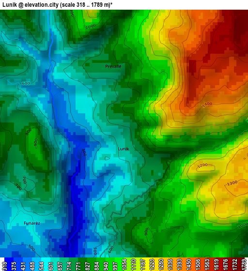
Below is the Elevation map of Lunik, which displays elevation range with different colors. Scale of the first map is from 318 to 1789 m (1043 to 5869 ft) with average elevation of 869.5 meters (=2853 ft) [note 1]
These maps also provides idea of topography and contour of this city, they are displayed at different zoom levels. More info about maps, scale and edge coordinates you can find below images.
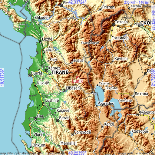
| \ | Map #1 | Topo.Map |
| Scale [m] | 318..1789 m | × |
| Scale [ft] | 1043..5869 ft | × |
| Average | 869.5 m = 2853 ft | × |
| Width | 7.34 km = 4.6 mi | 235 km = 146 mi |
| Height | 7.34 km = 4.6 mi | 235 km = 146 mi |
| ↑Max Latitude | 41.322182° | 42.33724° |
| Latitude at center | 41.28917° | 41.28917° |
| ↓Min Latitude | 41.256142° | 40.22399° |
| ← Min Longitude | 20.279665° | 18.91736° |
| Longitude center | 20.32361° | 20.32361° |
| →Max Longitude | 20.367555° | 21.72986° |
Nearby cities:
Cities around Lunik sort by population:
• Librazhd-Qendër elevation 554 m
10.3 km,  174°
174°
• Trebisht-Muçinë 790 m
22.3 km,  52°
52°
• Labinot-Fushë 165 m
22.2 km,  221°
221°
• Ostreni i Math 927 m
19.2 km,  34°
34°
• Polis-Gostimë 574 m
18.2 km,  197°
197°
• Labinot-Mal 823 m
17.4 km,  235°
235°
• Gostimë 309 m
17.4 km, 203°
• Martanesh 905 m
16.1 km,  320°
320°
• Hotolisht 656 m
16 km,  157°
157°
• Steblevë 1148 m
13.3 km,  66°
66°
• Librazhd 251 m
12.2 km,  183°
183°
• Orenjë 802 m
9.3 km,  266°
266°
Multilingual:
 En español:
Lunik elevación 668 m.
 En France:
Lunik élévation 668 m.


Sources and notes:
- [note 1] Map square and city borders are not equal. Map elevation data is calculated only from area inside that square.
- [src 1] Elevation data from geonames database provided with same terms of usage.
- [src 2] The elevation map of Lunik is generated using elevation data from NASA's 3 arcsec (90m) resolution SRTM data.
- [src 3] Base (background) map © OpenStreetMap contributors tiles are generated by Geofabrik and OpenTopoMap.
Copyright & License:
This Lunik Elevation Map is licensed under CC BY-SA. You may reuse any part from this page, if you give a proper credit by linking to this URL:
 More info on terms of use page.