Përrenjas-Fshat elevation
Përrenjas-Fshat (Elbasan), Albania elevation is 586 meters and Përrenjas-Fshat elevation in feet is 1923 ft above sea level [src 1]. Përrenjas-Fshat is a populated place (feature code) with elevation that is 212 meters (696 ft) bigger than average city elevation in Albania.
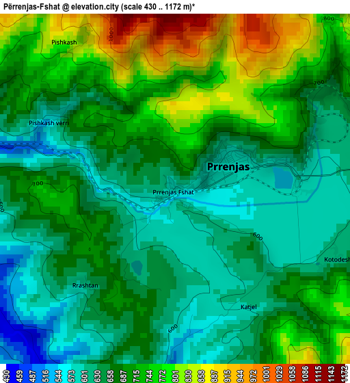
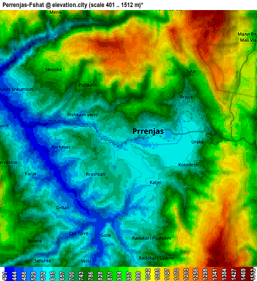
Below is the Elevation map of Përrenjas-Fshat, which displays elevation range with different colors. Scale of the first map is from 430 to 1172 m (1411 to 3845 ft) with average elevation of 685.5 meters (=2249 ft) [note 1]
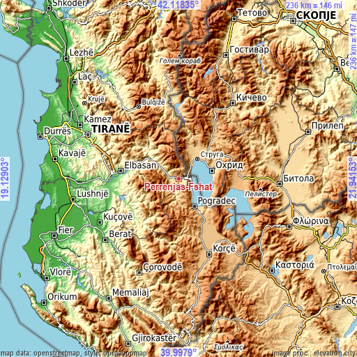
These maps also provides idea of topography and contour of this city, they are displayed at different zoom levels. More info about maps, scale and edge coordinates you can find below images.
| \ | Map #1 | Map #2 | Topo.Map |
| Scale [m] | 430..1172 m | 401..1512 m | × |
| Scale [ft] | 1411..3845 ft | 1316..4961 ft | × |
| Average | 685.5 m = 2249 ft | 821 m = 2694 ft | × |
| Width | 7.37 km = 4.6 mi | 14.74 km = 9.2 mi | 235.8 km = 146.5 mi |
| Height | 7.37 km = 4.6 mi | 14.74 km = 9.2 mi | 235.8 km = 146.5 mi |
| ↑Max Latitude | 41.099794° | 41.132901° | 42.11835° |
| Latitude at center | 41.06667° | 41.06667° | 41.06667° |
| ↓Min Latitude | 41.033529° | 41.000372° | 39.9979° |
| ← Min Longitude | 20.491335° | 20.447389° | 19.12903° |
| Longitude center | 20.53528° | 20.53528° | 20.53528° |
| →Max Longitude | 20.579225° | 20.623171° | 21.94153° |
Nearby cities:
Cities around Përrenjas-Fshat sort by population:
• Pogradec elevation 702 m
20.7 km,  151°
151°
• Librazhd-Qendër 554 m
22.1 km,  310°
310°
• Librazhd 251 m
22.3 km,  304°
304°
• Trebinjë 898 m
17.1 km,  174°
174°
• Hotolisht 656 m
15.3 km, 310°
• Udënisht 743 m
14.4 km,  142°
142°
• Velçan 1023 m
13.9 km,  206°
206°
• Stravaj 729 m
11.6 km,  234°
234°
• Proptisht 600 m
9.4 km,  197°
197°
• Qukës-Skënderbe 556 m
8.4 km,  283°
283°
• Rajcë 694 m
4.3 km,  52°
52°
• Përrenjas 591 m
1.3 km,  58°
58°
Multilingual:
 En español:
Përrenjas-Fshat elevación 586 m.
 En France:
Përrenjas-Fshat élévation 586 m.
 Auf Deutsch:
Përrenjas-Fshat höhe über dem Meeresspiegel ist 586 m.

Sources and notes:
- [note 1] Map square and city borders are not equal. Map elevation data is calculated only from area inside that square.
- [src 1] Elevation data from geonames database provided with same terms of usage.
- [src 2] The elevation map of Përrenjas-Fshat is generated using elevation data from NASA's 3 arcsec (90m) resolution SRTM data.
- [src 3] Base (background) map © OpenStreetMap contributors tiles are generated by Geofabrik and OpenTopoMap.
Copyright & License:
This Përrenjas-Fshat Elevation Map is licensed under CC BY-SA. You may reuse any part from this page, if you give a proper credit by linking to this URL:
 More info on terms of use page.