Progonat elevation
Progonat (Gjirokastër, Rrethi i Tepelenës), Albania elevation is 926 meters and Progonat elevation in feet is 3038 ft above sea level [src 1]. Progonat is a seat of a third-order administrative division (feature code) with elevation that is 552 meters (1811 ft) bigger than average city elevation in Albania.
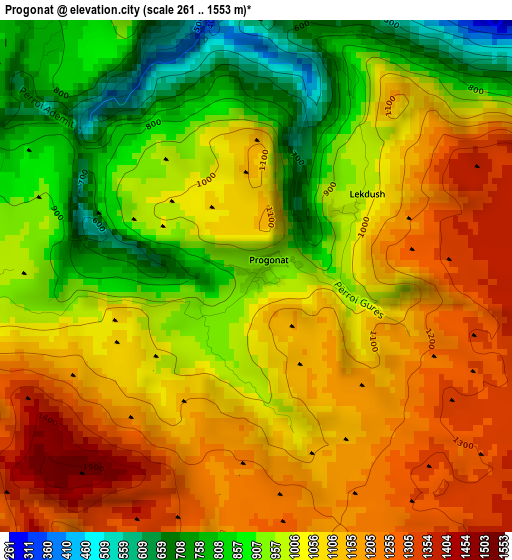
Below is the Elevation map of Progonat, which displays elevation range with different colors. Scale of the first map is from 261 to 1553 m (856 to 5095 ft) with average elevation of 1032.5 meters (=3387 ft) [note 1]
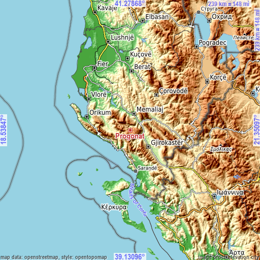
These maps also provides idea of topography and contour of this city, they are displayed at different zoom levels. More info about maps, scale and edge coordinates you can find below images.
| \ | Map #1 | Topo.Map |
| Scale [m] | 261..1553 m | × |
| Scale [ft] | 856..5095 ft | × |
| Average | 1032.5 m = 3387 ft | × |
| Width | 7.46 km = 4.6 mi | 238.8 km = 148.4 mi |
| Height | 7.46 km = 4.6 mi | 238.8 km = 148.4 mi |
| ↑Max Latitude | 40.24688° | 41.27868° |
| Latitude at center | 40.21333° | 40.21333° |
| ↓Min Latitude | 40.179763° | 39.13096° |
| ← Min Longitude | 19.900775° | 18.53847° |
| Longitude center | 19.94472° | 19.94472° |
| →Max Longitude | 19.988665° | 21.35097° |
Nearby cities:
Cities around Progonat sort by population:
• Gjirokastër elevation 286 m
22.5 km,  132°
132°
• Tepelenë 212 m
11.1 km,  34°
34°
• Memaliaj 115 m
15.7 km,  11°
11°
• Këlcyrë 178 m
23.5 km,  61°
61°
• Himarë 3 m
21 km,  233°
233°
• Brataj 257 m
24.2 km,  284°
284°
• Qestorat 553 m
24.1 km,  116°
116°
• Vergo 234 m
23.6 km,  166°
166°
• Vranisht 327 m
21.6 km,  268°
268°
• Odrie 286 m
20.8 km, 115°
• Kardhiq 491 m
12.4 km,  145°
145°
• Picar 295 m
10.2 km, 120°
Multilingual:
 En español:
Progonat elevación 926 m.
 En France:
Progonat élévation 926 m.
 Auf Deutsch:
Progonat höhe über dem Meeresspiegel ist 926 m.

Sources and notes:
- [note 1] Map square and city borders are not equal. Map elevation data is calculated only from area inside that square.
- [src 1] Elevation data from geonames database provided with same terms of usage.
- [src 2] The elevation map of Progonat is generated using elevation data from NASA's 3 arcsec (90m) resolution SRTM data.
- [src 3] Base (background) map © OpenStreetMap contributors tiles are generated by Geofabrik and OpenTopoMap.
Copyright & License:
This Progonat Elevation Map is licensed under CC BY-SA. You may reuse any part from this page, if you give a proper credit by linking to this URL:
 More info on terms of use page.