Sinjë elevation
Sinjë (Berat, Rrethi i Beratit), Albania elevation is 757 meters and Sinjë elevation in feet is 2484 ft above sea level [src 1]. Sinjë is a seat of a third-order administrative division (feature code) with elevation that is 383 meters (1257 ft) bigger than average city elevation in Albania.
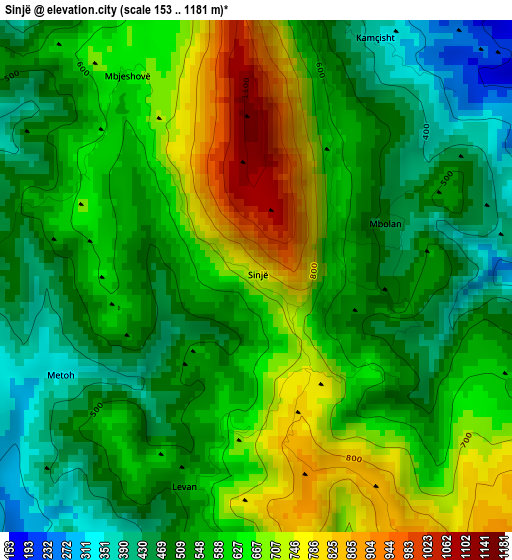
Below is the Elevation map of Sinjë, which displays elevation range with different colors. Scale of the first map is from 153 to 1181 m (502 to 3875 ft) with average elevation of 583.5 meters (=1914 ft) [note 1]
These maps also provides idea of topography and contour of this city, they are displayed at different zoom levels. More info about maps, scale and edge coordinates you can find below images.
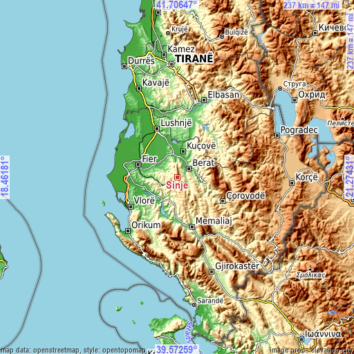
| \ | Map #1 | Topo.Map |
| Scale [m] | 153..1181 m | × |
| Scale [ft] | 502..3875 ft | × |
| Average | 583.5 m = 1914 ft | × |
| Width | 7.41 km = 4.6 mi | 237.3 km = 147.5 mi |
| Height | 7.41 km = 4.6 mi | 237.3 km = 147.5 mi |
| ↑Max Latitude | 40.681394° | 41.70647° |
| Latitude at center | 40.64806° | 40.64806° |
| ↓Min Latitude | 40.614709° | 39.57259° |
| ← Min Longitude | 19.824115° | 18.46181° |
| Longitude center | 19.86806° | 19.86806° |
| →Max Longitude | 19.912005° | 21.27431° |
Nearby cities:
Cities around Sinjë sort by population:
• Berat elevation 66 m
9.6 km,  47°
47°
• Ballsh 206 m
12.5 km,  244°
244°
• Greshicë 326 m
13.1 km,  215°
215°
• Kurjan 116 m
12.9 km,  306°
306°
• Dushk 50 m
12.8 km, 313°
• Otllak 42 m
12.1 km,  28°
28°
• Selitë 533 m
11.3 km,  188°
188°
• Cukalat 153 m
11.2 km,  324°
324°
• Kalenjë 508 m
10 km,  229°
229°
• Velabisht 60 m
8.1 km,  42°
42°
• Aranitas 297 m
7.9 km, 220°
• Ngraçan 428 m
6.4 km,  266°
266°
Multilingual:
 En español:
Sinjë elevación 757 m.
 En France:
Sinjë élévation 757 m.


Sources and notes:
- [note 1] Map square and city borders are not equal. Map elevation data is calculated only from area inside that square.
- [src 1] Elevation data from geonames database provided with same terms of usage.
- [src 2] The elevation map of Sinjë is generated using elevation data from NASA's 3 arcsec (90m) resolution SRTM data.
- [src 3] Base (background) map © OpenStreetMap contributors tiles are generated by Geofabrik and OpenTopoMap.
Copyright & License:
This Sinjë Elevation Map is licensed under CC BY-SA. You may reuse any part from this page, if you give a proper credit by linking to this URL:
 More info on terms of use page.