Kirāmān elevation
Kirāmān (Panjshir, Darah), Afghanistan elevation is 2527 meters and Kirāmān elevation in feet is 8291 ft above sea level [src 1]. Kirāmān is a seat of a second-order administrative division (feature code) with elevation that is 1108 meters (3635 ft) bigger than average city elevation in Afghanistan.
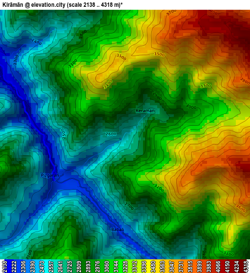
Below is the Elevation map of Kirāmān, which displays elevation range with different colors. Scale of the first map is from 2138 to 4318 m (7014 to 14167 ft) with average elevation of 2986.8 meters (=9799 ft) [note 1]
These maps also provides idea of topography and contour of this city, they are displayed at different zoom levels. More info about maps, scale and edge coordinates you can find below images.
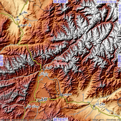
| \ | Map #1 | Topo.Map |
| Scale [m] | 2138..4318 m | × |
| Scale [ft] | 7014..14167 ft | × |
| Average | 2986.8 m = 9799 ft | × |
| Width | 7.98 km = 5 mi | 255.2 km = 158.6 mi |
| Height | 7.98 km = 5 mi | 255.2 km = 158.6 mi |
| ↑Max Latitude | 35.333159° | 36.43686° |
| Latitude at center | 35.2973° | 35.2973° |
| ↓Min Latitude | 35.261425° | 34.14147° |
| ← Min Longitude | 69.637305° | 68.275° |
| Longitude center | 69.68125° | 69.68125° |
| →Max Longitude | 69.725195° | 71.0875° |
Nearby cities:
Cities around Kirāmān sort by population:
• Bāzārak elevation 1965 m
15.2 km,  276°
276°
• Jabal os Saraj 1612 m
44.9 km,  243°
243°
• Sidqābād 1486 m
42.8 km,  224°
224°
• Now Dahānak 2629 m
46.7 km,  38°
38°
• Alah Sāy 1602 m
44.7 km,  175°
175°
• Mandōl 2003 m
44.4 km,  91°
91°
• Bāgh-e Maīdān 1988 m
43.3 km,  258°
258°
• Pul-e Ḩişār 1979 m
40.4 km,  331°
331°
• Shērwānī-ye Bālā 1786 m
32.3 km,  193°
193°
• Ḩājī Khēl 1914 m
30.7 km,  227°
227°
• ’Unābah 1770 m
28.5 km, 255°
• Khinj 2225 m
15.4 km,  18°
18°
Multilingual:
 En español:
Kirāmān elevación 2527 m.
 En France:
Kirāmān élévation 2527 m.
 Auf Deutsch:
Kirāmān höhe über dem Meeresspiegel ist 2527 m.

Sources and notes:
- [note 1] Map square and city borders are not equal. Map elevation data is calculated only from area inside that square.
- [src 1] Elevation data from geonames database provided with same terms of usage.
- [src 2] The elevation map of Kirāmān is generated using elevation data from NASA's 3 arcsec (90m) resolution SRTM data.
- [src 3] Base (background) map © OpenStreetMap contributors tiles are generated by Geofabrik and OpenTopoMap.
Copyright & License:
This Kirāmān Elevation Map is licensed under CC BY-SA. You may reuse any part from this page, if you give a proper credit by linking to this URL:
 More info on terms of use page.