Qal‘ah-ye Fārsī elevation
Qal‘ah-ye Fārsī (Herat, Farsī), Afghanistan elevation is 2286 meters and Qal‘ah-ye Fārsī elevation in feet is 7500 ft above sea level [src 1]. Qal‘ah-ye Fārsī is a seat of a second-order administrative division (feature code) with elevation that is 867 meters (2844 ft) bigger than average city elevation in Afghanistan.
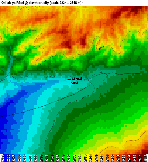
Below is the Elevation map of Qal‘ah-ye Fārsī, which displays elevation range with different colors. Scale of the first map is from 2224 to 2518 m (7297 to 8261 ft) with average elevation of 2351.4 meters (=7715 ft) [note 1]
These maps also provides idea of topography and contour of this city, they are displayed at different zoom levels. More info about maps, scale and edge coordinates you can find below images.
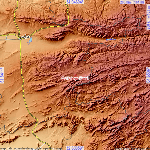
| \ | Map #1 | Topo.Map |
| Scale [m] | 2224..2518 m | × |
| Scale [ft] | 7297..8261 ft | × |
| Average | 2351.4 m = 7715 ft | × |
| Width | 8.12 km = 5 mi | 259.9 km = 161.5 mi |
| Height | 8.12 km = 5 mi | 259.9 km = 161.5 mi |
| ↑Max Latitude | 33.821806° | 34.94604° |
| Latitude at center | 33.78529° | 33.78529° |
| ↓Min Latitude | 33.748758° | 32.60859° |
| ← Min Longitude | 63.203405° | 61.8411° |
| Longitude center | 63.24735° | 63.24735° |
| →Max Longitude | 63.291295° | 64.6536° |
Nearby cities:
Cities around Qal‘ah-ye Fārsī sort by population:
• Karukh elevation 1340 m
98.4 km,  321°
321°
• Shahrak 2357 m
103.9 km,  69°
69°
• Chahār Burj 943 m
109.9 km,  297°
297°
• Taywarah 2160 m
112.5 km,  105°
105°
• Injīl 937 m
108.6 km, 301°
• Guz̄arah 983 m
106.6 km, 296°
• Dasht-e Qal‘ah 1718 m
100.4 km,  146°
146°
• Adraskan 1352 m
91.8 km,  260°
260°
• Chisht-e Sharīf 1572 m
77.2 km,  35°
35°
• Qaryeh-ye Owbeh 1287 m
65.3 km,  354°
354°
• Tītān 2194 m
58 km,  100°
100°
• Tūlak 2275 m
49.2 km,  64°
64°
Multilingual:
 En español:
Qal‘ah-ye Fārsī elevación 2286 m.
 En France:
Qal‘ah-ye Fārsī élévation 2286 m.
 Auf Deutsch:
Qal‘ah-ye Fārsī höhe über dem Meeresspiegel ist 2286 m.

Sources and notes:
- [note 1] Map square and city borders are not equal. Map elevation data is calculated only from area inside that square.
- [src 1] Elevation data from geonames database provided with same terms of usage.
- [src 2] The elevation map of Qal‘ah-ye Fārsī is generated using elevation data from NASA's 3 arcsec (90m) resolution SRTM data.
- [src 3] Base (background) map © OpenStreetMap contributors tiles are generated by Geofabrik and OpenTopoMap.
Copyright & License:
This Qal‘ah-ye Fārsī Elevation Map is licensed under CC BY-SA. You may reuse any part from this page, if you give a proper credit by linking to this URL:
 More info on terms of use page.