Zarghūn Shahr elevation
Zarghūn Shahr (Paktika), Afghanistan elevation is 2120 meters and Zarghūn Shahr elevation in feet is 6955 ft above sea level [src 1]. Zarghūn Shahr is a populated place (feature code) with elevation that is 701 meters (2300 ft) bigger than average city elevation in Afghanistan.
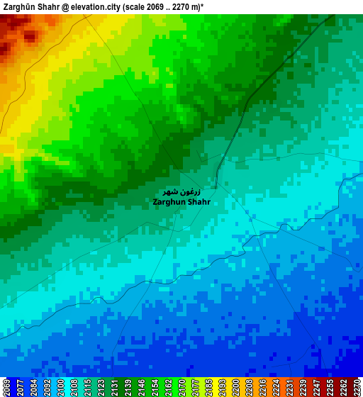
Below is the Elevation map of Zarghūn Shahr, which displays elevation range with different colors. Scale of the first map is from 2069 to 2270 m (6788 to 7448 ft) with average elevation of 2123.4 meters (=6967 ft) [note 1]
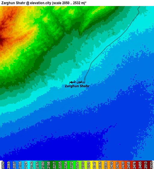
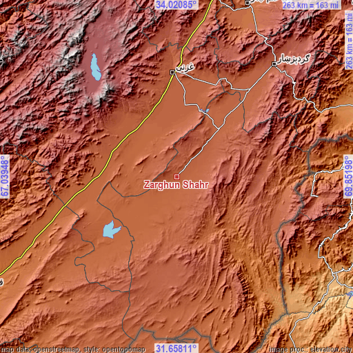
These maps also provides idea of topography and contour of this city, they are displayed at different zoom levels. More info about maps, scale and edge coordinates you can find below images.
| \ | Map #1 | Map #2 | Topo.Map |
| Scale [m] | 2069..2270 m | 2050..2532 m | × |
| Scale [ft] | 6788..7448 ft | 6726..8307 ft | × |
| Average | 2123.4 m = 6967 ft | 2146.3 m = 7042 ft | × |
| Width | 8.21 km = 5.1 mi | 16.42 km = 10.2 mi | 262.7 km = 163.2 mi |
| Height | 8.21 km = 5.1 mi | 16.42 km = 10.2 mi | 262.7 km = 163.2 mi |
| ↑Max Latitude | 32.884252° | 32.921148° | 34.02085° |
| Latitude at center | 32.84734° | 32.84734° | 32.84734° |
| ↓Min Latitude | 32.810413° | 32.773471° | 31.65811° |
| ← Min Longitude | 68.401785° | 68.357839° | 67.03948° |
| Longitude center | 68.44573° | 68.44573° | 68.44573° |
| →Max Longitude | 68.489675° | 68.533621° | 69.85198° |
Nearby cities:
Cities around Zarghūn Shahr sort by population:
• Zaṟah Sharan elevation 2154 m
46.4 km,  44°
44°
• Sharan 2145 m
45.1 km, 36°
• Gōmal Kêlay 1827 m
53.7 km,  134°
134°
• Mīray 2077 m
53.1 km,  359°
359°
• Qarah Bāgh 2089 m
50.1 km,  321°
321°
• Sarfirāz Kalā 2106 m
47.3 km,  288°
288°
• Ōmnah 2595 m
33.3 km,  79°
79°
• ‘Alāqahdārī Yōsuf Khēl 2239 m
29.7 km, 39°
• Khōshāmand 2011 m
26.5 km,  227°
227°
• Yaḩyá Khēl 2136 m
21.2 km,  61°
61°
• Jānī Khēl 2048 m
10.4 km,  205°
205°
• Khayr Kōṯ 2126 m
0.8 km,  28°
28°
Multilingual:
 En español:
Zarghūn Shahr elevación 2120 m.
 En France:
Zarghūn Shahr élévation 2120 m.
 Auf Deutsch:
Zarghūn Shahr höhe über dem Meeresspiegel ist 2120 m.

Sources and notes:
- [note 1] Map square and city borders are not equal. Map elevation data is calculated only from area inside that square.
- [src 1] Elevation data from geonames database provided with same terms of usage.
- [src 2] The elevation map of Zarghūn Shahr is generated using elevation data from NASA's 3 arcsec (90m) resolution SRTM data.
- [src 3] Base (background) map © OpenStreetMap contributors tiles are generated by Geofabrik and OpenTopoMap.
Copyright & License:
This Zarghūn Shahr Elevation Map is licensed under CC BY-SA. You may reuse any part from this page, if you give a proper credit by linking to this URL:
 More info on terms of use page.