Mwinilunga elevation
Mwinilunga (North-Western), Zambia elevation is 1364 meters and Mwinilunga elevation in feet is 4475 ft above sea level [src 1]. Mwinilunga is a populated place (feature code) with elevation that is 221 meters (725 ft) bigger than average city elevation in Zambia.
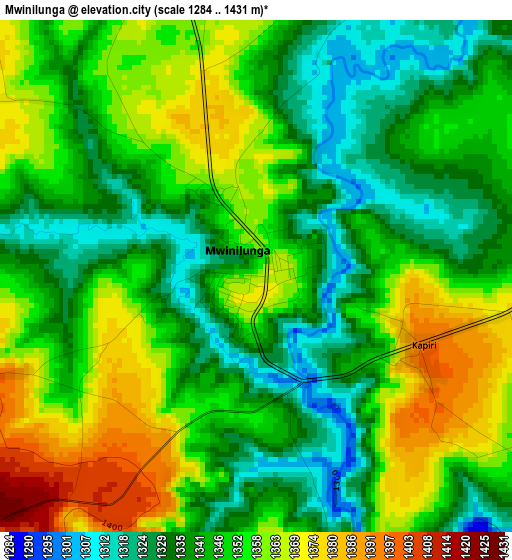
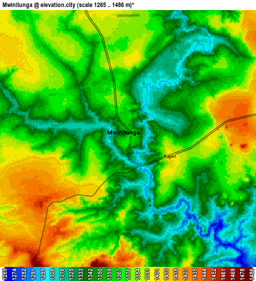
Below is the Elevation map of Mwinilunga, which displays elevation range with different colors. Scale of the first map is from 1284 to 1431 m (4213 to 4695 ft) with average elevation of 1348.1 meters (=4423 ft) [note 1]
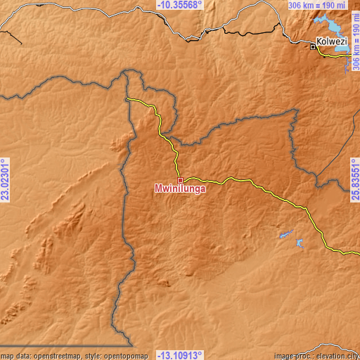
These maps also provides idea of topography and contour of this city, they are displayed at different zoom levels. More info about maps, scale and edge coordinates you can find below images.
| \ | Map #1 | Map #2 | Topo.Map |
| Scale [m] | 1284..1431 m | 1265..1486 m | × |
| Scale [ft] | 4213..4695 ft | 4150..4875 ft | × |
| Average | 1348.1 m = 4423 ft | 1365.1 m = 4479 ft | × |
| Width | 9.57 km = 5.9 mi | 19.14 km = 11.9 mi | 306.2 km = 190.3 mi |
| Height | 9.57 km = 5.9 mi | 19.14 km = 11.9 mi | 306.2 km = 190.3 mi |
| ↑Max Latitude | -11.69281° | -11.649773° | -10.35568° |
| Latitude at center | -11.73584° | -11.73584° | -11.73584° |
| ↓Min Latitude | -11.778863° | -11.82188° | -13.10913° |
| ← Min Longitude | 24.385315° | 24.341369° | 23.02301° |
| Longitude center | 24.42926° | 24.42926° | 24.42926° |
| →Max Longitude | 24.473205° | 24.517151° | 25.83551° |
Nearby cities:
Cities around Mwinilunga sort by population:
• Chingola elevation 1363 m
385.7 km,  103°
103°
• Chililabombwe 1316 m
375.6 km, 100°
• Kansanshi 1429 m
221 km, 100°
• Kaoma 1126 m
341.2 km,  173°
173°
• Kalengwa 1197 m
202.2 km,  162°
162°
• Limulunga 1023 m
399 km,  200°
200°
• Zambezi 1079 m
247.1 km,  215°
215°
• Kabompo 1113 m
207.9 km,  186°
186°
• Mufumbwe 1143 m
220.2 km, 169°
• Kasempa 1235 m
244.8 km,  141°
141°
• Solwezi 1381 m
218.6 km, 102°
• Lukulu 1048 m
319.9 km, 203°
Multilingual:
 En español:
Mwinilunga elevación 1364 m.
 En France:
Mwinilunga élévation 1364 m.
 Auf Deutsch:
Mwinilunga höhe über dem Meeresspiegel ist 1364 m.

Sources and notes:
- [note 1] Map square and city borders are not equal. Map elevation data is calculated only from area inside that square.
- [src 1] Elevation data from geonames database provided with same terms of usage.
- [src 2] The elevation map of Mwinilunga is generated using elevation data from NASA's 3 arcsec (90m) resolution SRTM data.
- [src 3] Base (background) map © OpenStreetMap contributors tiles are generated by Geofabrik and OpenTopoMap.
Copyright & License:
This Mwinilunga Elevation Map is licensed under CC BY-SA. You may reuse any part from this page, if you give a proper credit by linking to this URL:
 More info on terms of use page.