East London elevation
East London (Eastern Cape, Buffalo City Metropolitan Municipality), South Africa elevation is 48 meters and East London elevation in feet is 157 ft above sea level [src 1]. East London is a seat of a second-order administrative division (feature code) with elevation that is 924 meters (3031 ft) smaller than average city elevation in South Africa.
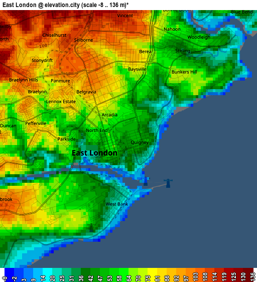
Below is the Elevation map of East London, which displays elevation range with different colors. Scale of the first map is from -8 to 136 m (-26 to 446 ft) with average elevation of 63.5 meters (=208 ft) [note 1]
These maps also provides idea of topography and contour of this city, they are displayed at different zoom levels. More info about maps, scale and edge coordinates you can find below images.
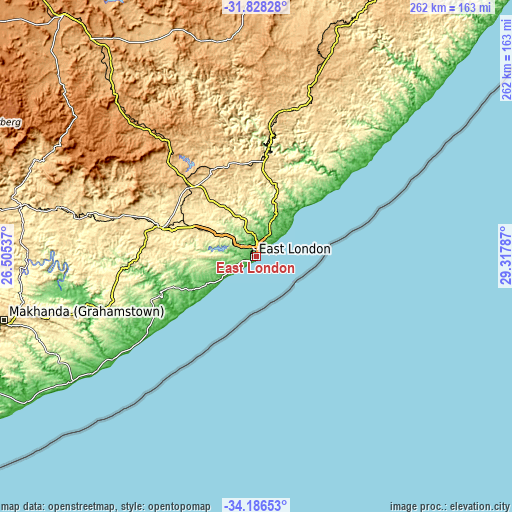
| \ | Map #1 | Map #2 | Topo.Map |
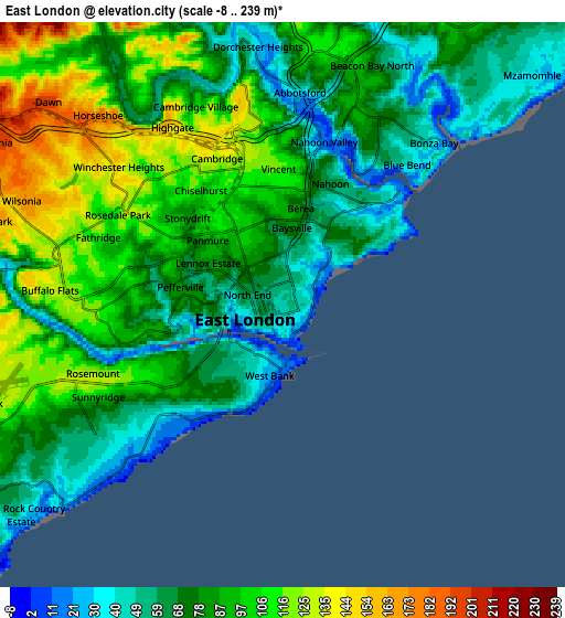
| Scale [m] | -8..136 m | -8..239 m | × |
| Scale [ft] | -26..446 ft | -26..784 ft | × |
| Average | 63.5 m = 208 ft | 83.5 m = 274 ft | × |
| Width | 8.19 km = 5.1 mi | 16.39 km = 10.2 mi | 262.2 km = 162.9 mi |
| Height | 8.19 km = 5.1 mi | 16.39 km = 10.2 mi | 262.2 km = 162.9 mi |
| ↑Max Latitude | -32.978433° | -32.941561° | -31.82828° |
| Latitude at center | -33.01529° | -33.01529° | -33.01529° |
| ↓Min Latitude | -33.052132° | -33.088958° | -34.18653° |
| ← Min Longitude | 27.867675° | 27.823729° | 26.50537° |
| Longitude center | 27.91162° | 27.91162° | 27.91162° |
| →Max Longitude | 27.955565° | 27.999511° | 29.31787° |
Nearby cities:
Cities around East London sort by population:
• Bhisho elevation 535 m
47.6 km,  293°
293°
• Grahamstown 551 m
132.3 km,  255°
255°
• Fort Beaufort 444 m
122.3 km,  282°
282°
• Stutterheim 849 m
67.2 km,  317°
317°
• Butterworth 545 m
79.3 km,  16°
16°
• Port Alfred 35 m
114.7 km,  236°
236°
• Whittlesea 1062 m
138.1 km,  312°
312°
• Ilinge 1107 m
141.3 km, 324°
• Alice 522 m
103.7 km, 284°
• Cofimvaba 959 m
117 km,  344°
344°
• Peddie 314 m
77.1 km,  254°
254°
• Komga 630 m
48.8 km,  357°
357°
Multilingual:
 En español:
East London elevación 48 m.
 En France:
East London élévation 48 m.
 Auf Deutsch:
East London höhe über dem Meeresspiegel ist 48 m.

Sources and notes:
- [note 1] Map square and city borders are not equal. Map elevation data is calculated only from area inside that square.
- [src 1] Elevation data from geonames database provided with same terms of usage.
- [src 2] The elevation map of East London is generated using elevation data from NASA's 3 arcsec (90m) resolution SRTM data.
- [src 3] Base (background) map © OpenStreetMap contributors tiles are generated by Geofabrik and OpenTopoMap.
Copyright & License:
This East London Elevation Map is licensed under CC BY-SA. You may reuse any part from this page, if you give a proper credit by linking to this URL:
 More info on terms of use page.