Mustabā’ elevation
Mustabā’ (Ḩajjah, Mustaba), Yemen elevation is 247 meters and Mustabā’ elevation in feet is 810 ft above sea level [src 1]. Mustabā’ is a seat of a second-order administrative division (feature code) with elevation that is 1065 meters (3494 ft) smaller than average city elevation in Yemen.
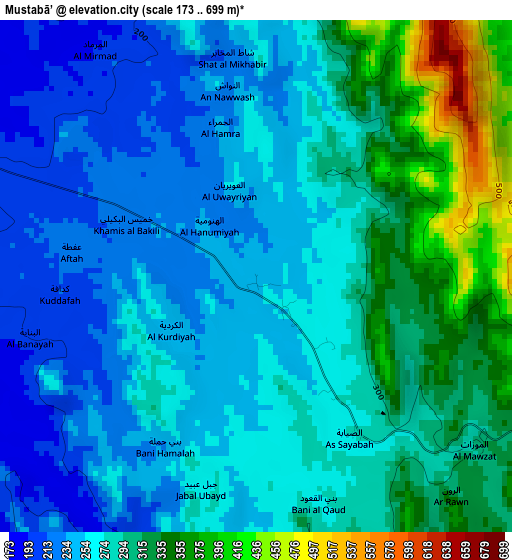
Below is the Elevation map of Mustabā’, which displays elevation range with different colors. Scale of the first map is from 173 to 699 m (568 to 2293 ft) with average elevation of 279.2 meters (=916 ft) [note 1]
These maps also provides idea of topography and contour of this city, they are displayed at different zoom levels. More info about maps, scale and edge coordinates you can find below images.
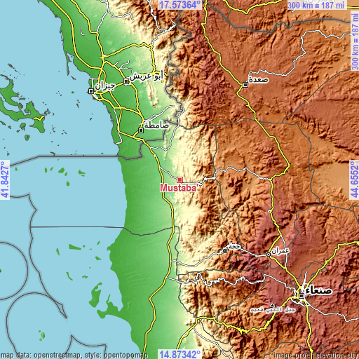
| \ | Map #1 | Topo.Map |
| Scale [m] | 173..699 m | × |
| Scale [ft] | 568..2293 ft | × |
| Average | 279.2 m = 916 ft | × |
| Width | 9.38 km = 5.8 mi | 300.2 km = 186.5 mi |
| Height | 9.38 km = 5.8 mi | 300.3 km = 186.6 mi |
| ↑Max Latitude | 16.27035° | 17.57364° |
| Latitude at center | 16.22816° | 16.22816° |
| ↓Min Latitude | 16.185961° | 14.87342° |
| ← Min Longitude | 43.205005° | 41.8427° |
| Longitude center | 43.24895° | 43.24895° |
| →Max Longitude | 43.292895° | 44.6552° |
Nearby cities:
Cities around Mustabā’ sort by population:
• Ash Shāhil elevation 1596 m
43.5 km,  157°
157°
• Al Madān 2112 m
42.2 km,  90°
90°
• Sūq Shamar 1177 m
40.2 km, 161°
• Şuwayr 1269 m
38.9 km,  97°
97°
• Al Maḩābishah 1570 m
37 km,  147°
147°
• Al Miftāḩ 1976 m
36.4 km,  140°
140°
• Ḩaraḑ 105 m
28.6 km,  314°
314°
• Khayrān 470 m
26.8 km, 148°
• Abs 194 m
25.6 km,  192°
192°
• Aslam 799 m
20.5 km, 155°
• Kushar 1586 m
20.1 km,  113°
113°
• Washḩah 1514 m
19.4 km,  62°
62°
Multilingual:
 En español:
Mustabā’ elevación 247 m.
 En France:
Mustabā’ élévation 247 m.
 Auf Deutsch:
Mustabā’ höhe über dem Meeresspiegel ist 247 m.

Sources and notes:
- [note 1] Map square and city borders are not equal. Map elevation data is calculated only from area inside that square.
- [src 1] Elevation data from geonames database provided with same terms of usage.
- [src 2] The elevation map of Mustabā’ is generated using elevation data from NASA's 3 arcsec (90m) resolution SRTM data.
- [src 3] Base (background) map © OpenStreetMap contributors tiles are generated by Geofabrik and OpenTopoMap.
Copyright & License:
This Mustabā’ Elevation Map is licensed under CC BY-SA. You may reuse any part from this page, if you give a proper credit by linking to this URL:
 More info on terms of use page.