Al Maşlūb elevation
Al Maşlūb (Al Jawf, Al Maslub), Yemen elevation is 1152 meters and Al Maşlūb elevation in feet is 3780 ft above sea level [src 1]. Al Maşlūb is a seat of a second-order administrative division (feature code) with elevation that is 160 meters (525 ft) smaller than average city elevation in Yemen.
Below is the Elevation map of Al Maşlūb, which displays elevation range with different colors. Scale of the first map is from 1129 to 1174 m (3704 to 3852 ft) with average elevation of 1149.1 meters (=3770 ft) [note 1]
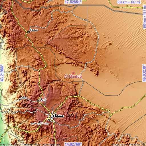
These maps also provides idea of topography and contour of this city, they are displayed at different zoom levels. More info about maps, scale and edge coordinates you can find below images.
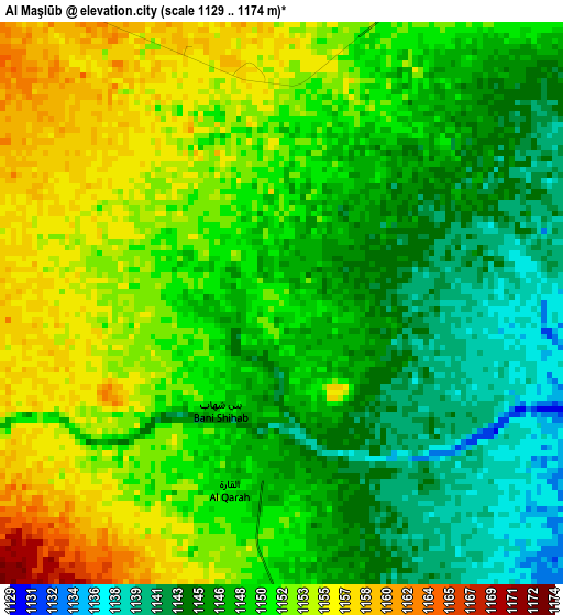
| \ | Map #1 | Topo.Map |
| Scale [m] | 1129..1174 m | × |
| Scale [ft] | 3704..3852 ft | × |
| Average | 1149.1 m = 3770 ft | × |
| Width | 9.39 km = 5.8 mi | 300.3 km = 186.6 mi |
| Height | 9.39 km = 5.8 mi | 300.3 km = 186.6 mi |
| ↑Max Latitude | 16.22491° | 17.52851° |
| Latitude at center | 16.18271° | 16.18271° |
| ↓Min Latitude | 16.140501° | 14.82768° |
| ← Min Longitude | 44.582185° | 43.21988° |
| Longitude center | 44.62613° | 44.62613° |
| →Max Longitude | 44.670075° | 46.03238° |
Nearby cities:
Cities around Al Maşlūb sort by population:
• Al Ḩazm elevation 1116 m
16.2 km,  97°
97°
• Rajūzah 2077 m
61.8 km,  338°
338°
• Al Ḩarf 1570 m
60.2 km,  289°
289°
• Dhaybīn 1876 m
57.8 km,  246°
246°
• Al Khirāb 1380 m
54.7 km,  319°
319°
• Majzar 1206 m
40.3 km,  156°
156°
• Al Ḩumaydāt 1305 m
39.6 km,  327°
327°
• Ar Rawḑ 1099 m
23.8 km,  124°
124°
• Az Zāhir 1206 m
20.5 km, 316°
• Ḩişn Banī Sa‘d 1192 m
18.8 km,  302°
302°
• Al Ghayl 1137 m
10.1 km,  145°
145°
• Al Matūn 1164 m
6.9 km, 320°
Multilingual:
 En español:
Al Maşlūb elevación 1152 m.
 En France:
Al Maşlūb élévation 1152 m.
 Auf Deutsch:
Al Maşlūb höhe über dem Meeresspiegel ist 1152 m.

Sources and notes:
- [note 1] Map square and city borders are not equal. Map elevation data is calculated only from area inside that square.
- [src 1] Elevation data from geonames database provided with same terms of usage.
- [src 2] The elevation map of Al Maşlūb is generated using elevation data from NASA's 3 arcsec (90m) resolution SRTM data.
- [src 3] Base (background) map © OpenStreetMap contributors tiles are generated by Geofabrik and OpenTopoMap.
Copyright & License:
This Al Maşlūb Elevation Map is licensed under CC BY-SA. You may reuse any part from this page, if you give a proper credit by linking to this URL:
 More info on terms of use page.