Al ‘Ulayb elevation
Al ‘Ulayb (Ḩaḑramawt, Ghayl Bin Yamin), Yemen elevation is 1079 meters and Al ‘Ulayb elevation in feet is 3540 ft above sea level [src 1]. Al ‘Ulayb is a seat of a second-order administrative division (feature code) with elevation that is 233 meters (764 ft) smaller than average city elevation in Yemen.
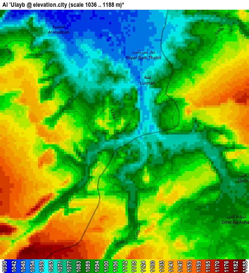
Below is the Elevation map of Al ‘Ulayb, which displays elevation range with different colors. Scale of the first map is from 1036 to 1188 m (3399 to 3898 ft) with average elevation of 1102.9 meters (=3618 ft) [note 1]
These maps also provides idea of topography and contour of this city, they are displayed at different zoom levels. More info about maps, scale and edge coordinates you can find below images.
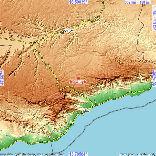
| \ | Map #1 | Topo.Map |
| Scale [m] | 1036..1188 m | × |
| Scale [ft] | 3399..3898 ft | × |
| Average | 1102.9 m = 3618 ft | × |
| Width | 9.43 km = 5.9 mi | 301.8 km = 187.5 mi |
| Height | 9.43 km = 5.9 mi | 301.9 km = 187.6 mi |
| ↑Max Latitude | 15.189884° | 16.50039° |
| Latitude at center | 15.14747° | 15.14747° |
| ↓Min Latitude | 15.105047° | 13.78584° |
| ← Min Longitude | 49.029305° | 47.667° |
| Longitude center | 49.07325° | 49.07325° |
| →Max Longitude | 49.117195° | 50.4795° |
Nearby cities:
Cities around Al ‘Ulayb sort by population:
• Mukalla elevation 39 m
67.5 km,  175°
175°
• At Taḩāluf 663 m
93.1 km,  340°
340°
• Al Ḩamdī 651 m
94.3 km, 340°
• Suḩayl Shibām 680 m
97.2 km,  331°
331°
• Tarīm 617 m
101.4 km,  355°
355°
• Ad Dīs ash Sharqīyah 75 m
97.7 km,  105°
105°
• Burūm 44 m
87.7 km,  186°
186°
• Şīf 1009 m
81.9 km,  283°
283°
• Al Bāţinah 948 m
78.1 km,  298°
298°
• Ash Shiḩr 17 m
71.6 km,  126°
126°
• Sāh 827 m
53.4 km, 333°
• Ghayl Bā Wazīr 87 m
51.9 km,  142°
142°
Multilingual:
 En español:
Al ‘Ulayb elevación 1079 m.
 En France:
Al ‘Ulayb élévation 1079 m.
 Auf Deutsch:
Al ‘Ulayb höhe über dem Meeresspiegel ist 1079 m.

Sources and notes:
- [note 1] Map square and city borders are not equal. Map elevation data is calculated only from area inside that square.
- [src 1] Elevation data from geonames database provided with same terms of usage.
- [src 2] The elevation map of Al ‘Ulayb is generated using elevation data from NASA's 3 arcsec (90m) resolution SRTM data.
- [src 3] Base (background) map © OpenStreetMap contributors tiles are generated by Geofabrik and OpenTopoMap.
Copyright & License:
This Al ‘Ulayb Elevation Map is licensed under CC BY-SA. You may reuse any part from this page, if you give a proper credit by linking to this URL:
 More info on terms of use page.