Al Bayda elevation
Al Bayda, Yemen elevation is 2005 meters and Al Bayda elevation in feet is 6578 ft above sea level [src 1]. Al Bayda is a seat of a first-order administrative division (feature code) with elevation that is 693 meters (2274 ft) bigger than average city elevation in Yemen.
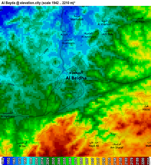
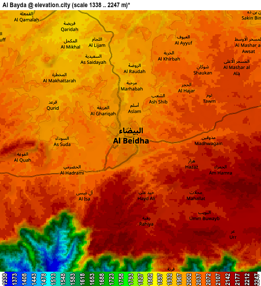
Below is the Elevation map of Al Bayda, which displays elevation range with different colors. Scale of the first map is from 1942 to 2210 m (6371 to 7251 ft) with average elevation of 2047.5 meters (=6718 ft) [note 1]
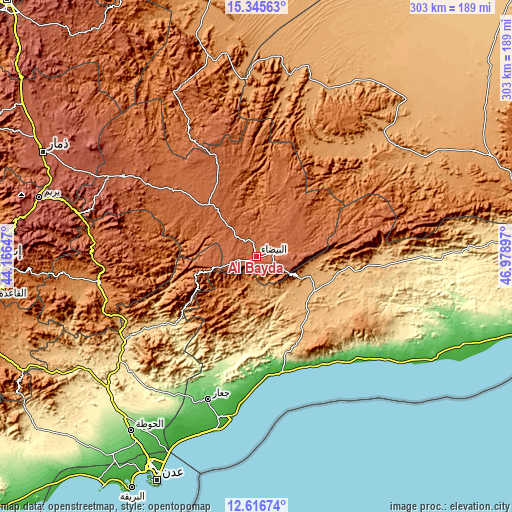
These maps also provides idea of topography and contour of this city, they are displayed at different zoom levels. More info about maps, scale and edge coordinates you can find below images.
| \ | Map #1 | Map #2 | Topo.Map |
| Scale [m] | 1942..2210 m | 1338..2247 m | × |
| Scale [ft] | 6371..7251 ft | 4390..7372 ft | × |
| Average | 2047.5 m = 6718 ft | 2023.2 m = 6638 ft | × |
| Width | 9.48 km = 5.9 mi | 18.97 km = 11.8 mi | 303.4 km = 188.5 mi |
| Height | 9.48 km = 5.9 mi | 18.97 km = 11.8 mi | 303.4 km = 188.5 mi |
| ↑Max Latitude | 14.027869° | 14.0705° | 15.34563° |
| Latitude at center | 13.98523° | 13.98523° | 13.98523° |
| ↓Min Latitude | 13.942583° | 13.899929° | 12.61674° |
| ← Min Longitude | 45.528775° | 45.484829° | 44.16647° |
| Longitude center | 45.57272° | 45.57272° | 45.57272° |
| →Max Longitude | 45.616665° | 45.660611° | 46.97897° |
Nearby cities:
Cities around Al Bayda sort by population:
• Jawf al Maqbābah elevation 919 m
32.7 km,  120°
120°
• As Suwaydā 1529 m
43 km,  239°
239°
• Raşad 1657 m
42.1 km,  223°
223°
• Madīnat Lab‘ūs 2281 m
37.2 km,  249°
249°
• Lawdar 993 m
33.9 km,  109°
109°
• Banī Bakr 2154 m
33.5 km,  260°
260°
• Āl Ma‘ūdah 2006 m
32.1 km,  321°
321°
• Sūq Sibāḩ 1278 m
27.2 km,  225°
225°
• Aş Şawma‘ah 2040 m
27 km,  65°
65°
• Dhī Nā‘im 1956 m
19 km,  314°
314°
• Mukayrās 2161 m
11.5 km, 113°
• Az Zāhir 2056 m
9.9 km, 257°
Multilingual:
 En español:
Al Bayda elevación 2005 m.
 En France:
Al Bayda élévation 2005 m.
 Auf Deutsch:
Al Bayda höhe über dem Meeresspiegel ist 2005 m.

Sources and notes:
- [note 1] Map square and city borders are not equal. Map elevation data is calculated only from area inside that square.
- [src 1] Elevation data from geonames database provided with same terms of usage.
- [src 2] The elevation map of Al Bayda is generated using elevation data from NASA's 3 arcsec (90m) resolution SRTM data.
- [src 3] Base (background) map © OpenStreetMap contributors tiles are generated by Geofabrik and OpenTopoMap.
Copyright & License:
This Al Bayda Elevation Map is licensed under CC BY-SA. You may reuse any part from this page, if you give a proper credit by linking to this URL:
 More info on terms of use page.