Al Ghayz̧ah elevation
Al Ghayz̧ah (Al Mahrah, Al Ghaydah), Yemen elevation is 17 meters and Al Ghayz̧ah elevation in feet is 56 ft above sea level [src 1]. Al Ghayz̧ah is a seat of a first-order administrative division (feature code) with elevation that is 1295 meters (4249 ft) smaller than average city elevation in Yemen.
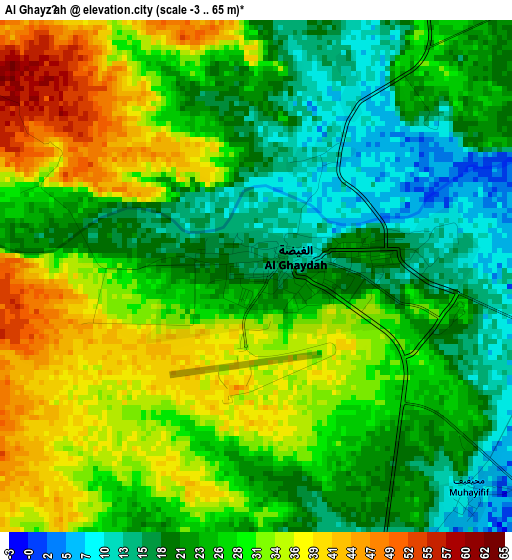
Below is the Elevation map of Al Ghayz̧ah, which displays elevation range with different colors. Scale of the first map is from -3 to 65 m (-10 to 213 ft) with average elevation of 26.6 meters (=87 ft) [note 1]
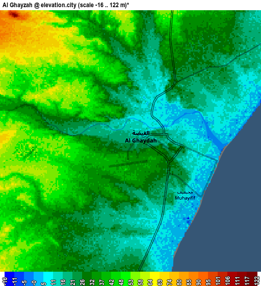
These maps also provides idea of topography and contour of this city, they are displayed at different zoom levels. More info about maps, scale and edge coordinates you can find below images.
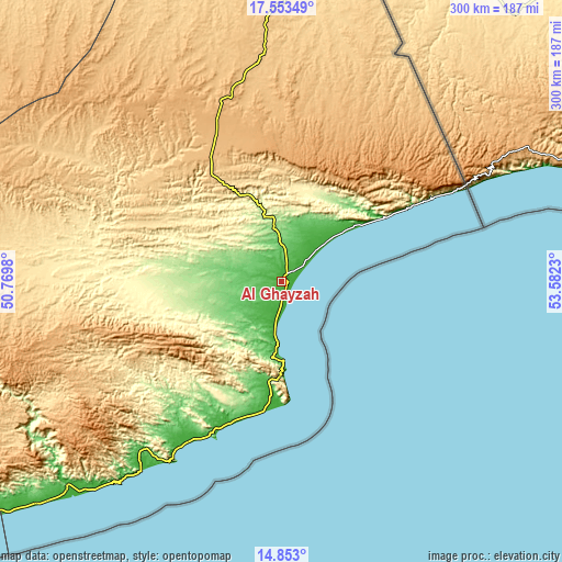
| \ | Map #1 | Map #2 | Topo.Map |
| Scale [m] | -3..65 m | -16..122 m | × |
| Scale [ft] | -10..213 ft | -52..400 ft | × |
| Average | 26.6 m = 87 ft | 33 m = 108 ft | × |
| Width | 9.38 km = 5.8 mi | 18.77 km = 11.7 mi | 300.3 km = 186.6 mi |
| Height | 9.38 km = 5.8 mi | 18.77 km = 11.7 mi | 300.3 km = 186.6 mi |
| ↑Max Latitude | 16.250064° | 16.292249° | 17.55349° |
| Latitude at center | 16.20787° | 16.20787° | 16.20787° |
| ↓Min Latitude | 16.165667° | 16.123455° | 14.853° |
| ← Min Longitude | 52.132105° | 52.088159° | 50.7698° |
| Longitude center | 52.17605° | 52.17605° | 52.17605° |
| →Max Longitude | 52.219995° | 52.263941° | 53.5823° |
Nearby cities:
Cities around Al Ghayz̧ah sort by population:
• Ad Dīs ash Sharqīyah elevation 75 m
278.9 km,  238°
238°
• Thamūd 661 m
268.8 km,  296°
296°
• Ar Raydah 10 m
223.7 km,  234°
234°
• Rumāh 697 m
219.5 km,  309°
309°
• Shiḩan as Suflá 545 m
176.9 km,  10°
10°
• Daḩasuways 268 m
163.7 km,  250°
250°
• Sayḩūt 8 m
149 km,  221°
221°
• Bi’r Ḩāt 752 m
124.2 km,  356°
356°
• Ḩawf 17 m
103 km,  62°
62°
• Qishn 8 m
102.1 km,  211°
211°
• Al Qurḩ 621 m
94.2 km, 308°
• Ḩaşwayn 10 m
69.1 km,  186°
186°
Multilingual:
 En español:
Al Ghayz̧ah elevación 17 m.
 En France:
Al Ghaydah élévation 17 m.
 Auf Deutsch:
al-Ghaida höhe über dem Meeresspiegel ist 17 m.

Sources and notes:
- [note 1] Map square and city borders are not equal. Map elevation data is calculated only from area inside that square.
- [src 1] Elevation data from geonames database provided with same terms of usage.
- [src 2] The elevation map of Al Ghayz̧ah is generated using elevation data from NASA's 3 arcsec (90m) resolution SRTM data.
- [src 3] Base (background) map © OpenStreetMap contributors tiles are generated by Geofabrik and OpenTopoMap.
Copyright & License:
This Al Ghayz̧ah Elevation Map is licensed under CC BY-SA. You may reuse any part from this page, if you give a proper credit by linking to this URL:
 More info on terms of use page.