Ataq elevation
Ataq (Shabwah), Yemen elevation is 1148 meters and Ataq elevation in feet is 3766 ft above sea level [src 1]. Ataq is a seat of a first-order administrative division (feature code) with elevation that is 164 meters (538 ft) smaller than average city elevation in Yemen.
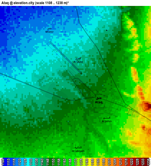
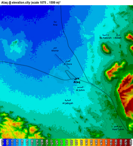
Below is the Elevation map of Ataq, which displays elevation range with different colors. Scale of the first map is from 1108 to 1238 m (3635 to 4062 ft) with average elevation of 1148.3 meters (=3767 ft) [note 1]
These maps also provides idea of topography and contour of this city, they are displayed at different zoom levels. More info about maps, scale and edge coordinates you can find below images.
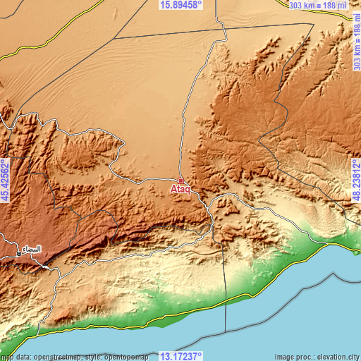
| \ | Map #1 | Map #2 | Topo.Map |
| Scale [m] | 1108..1238 m | 1075..1599 m | × |
| Scale [ft] | 3635..4062 ft | 3527..5246 ft | × |
| Average | 1148.3 m = 3767 ft | 1183 m = 3881 ft | × |
| Width | 9.46 km = 5.9 mi | 18.92 km = 11.8 mi | 302.7 km = 188.1 mi |
| Height | 9.46 km = 5.9 mi | 18.92 km = 11.8 mi | 302.7 km = 188.1 mi |
| ↑Max Latitude | 14.580204° | 14.62273° | 15.89458° |
| Latitude at center | 14.53767° | 14.53767° | 14.53767° |
| ↓Min Latitude | 14.495128° | 14.452577° | 13.17237° |
| ← Min Longitude | 46.787925° | 46.743979° | 45.42562° |
| Longitude center | 46.83187° | 46.83187° | 46.83187° |
| →Max Longitude | 46.875815° | 46.919761° | 48.23812° |
Nearby cities:
Cities around Ataq sort by population:
• Khimār elevation 1344 m
26.2 km,  202°
202°
• AL-khashā upper 1323 m
25.4 km,  210°
210°
• Mayfa‘ah 394 m
86.1 km,  109°
109°
• Jayshān 1562 m
77.1 km,  245°
245°
• Khawrah 1199 m
73.9 km,  260°
260°
• Marbāţ 1547 m
60.4 km,  232°
232°
• Al Maḩfid 660 m
54 km,  170°
170°
• Jawl al Majma‘ 1092 m
48.7 km,  25°
25°
• Ar Rawḑah 839 m
48.5 km,  99°
99°
• Nişāb 1088 m
36.6 km, 264°
• Ḩabbān 973 m
33.3 km,  127°
127°
• Said 1253 m
23.5 km, 169°
Multilingual:
 En español:
Ataq elevación 1148 m.
 En France:
Ataq élévation 1148 m.


Sources and notes:
- [note 1] Map square and city borders are not equal. Map elevation data is calculated only from area inside that square.
- [src 1] Elevation data from geonames database provided with same terms of usage.
- [src 2] The elevation map of Ataq is generated using elevation data from NASA's 3 arcsec (90m) resolution SRTM data.
- [src 3] Base (background) map © OpenStreetMap contributors tiles are generated by Geofabrik and OpenTopoMap.
Copyright & License:
This Ataq Elevation Map is licensed under CC BY-SA. You may reuse any part from this page, if you give a proper credit by linking to this URL:
 More info on terms of use page.