Dhī as Sufāl elevation
Dhī as Sufāl (Ibb), Yemen elevation is 1857 meters and Dhī as Sufāl elevation in feet is 6093 ft above sea level [src 1]. Dhī as Sufāl is a seat of a second-order administrative division (feature code) with elevation that is 545 meters (1788 ft) bigger than average city elevation in Yemen.
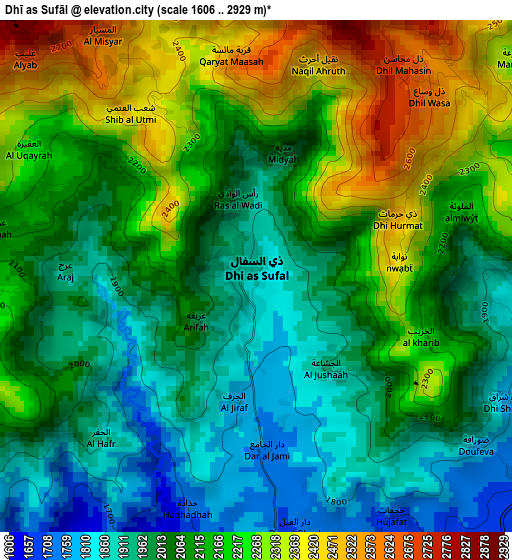
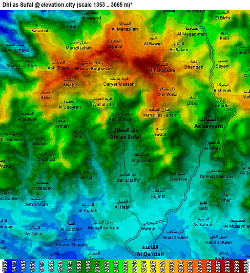
Below is the Elevation map of Dhī as Sufāl, which displays elevation range with different colors. Scale of the first map is from 1606 to 2929 m (5269 to 9610 ft) with average elevation of 2100.2 meters (=6890 ft) [note 1]
These maps also provides idea of topography and contour of this city, they are displayed at different zoom levels. More info about maps, scale and edge coordinates you can find below images.
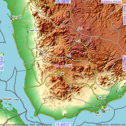
| \ | Map #1 | Map #2 | Topo.Map |
| Scale [m] | 1606..2929 m | 1353..3065 m | × |
| Scale [ft] | 5269..9610 ft | 4439..10056 ft | × |
| Average | 2100.2 m = 6890 ft | 2012.3 m = 6602 ft | × |
| Width | 9.49 km = 5.9 mi | 18.98 km = 11.8 mi | 303.6 km = 188.6 mi |
| Height | 9.49 km = 5.9 mi | 18.98 km = 11.8 mi | 303.6 km = 188.6 mi |
| ↑Max Latitude | 13.877127° | 13.919785° | 15.19579° |
| Latitude at center | 13.83446° | 13.83446° | 13.83446° |
| ↓Min Latitude | 13.791786° | 13.749103° | 12.46512° |
| ← Min Longitude | 44.070745° | 44.026799° | 42.70844° |
| Longitude center | 44.11469° | 44.11469° | 44.11469° |
| →Max Longitude | 44.158635° | 44.202581° | 45.52094° |
Nearby cities:
Cities around Dhī as Sufāl sort by population:
• Ta‘izz elevation 1316 m
30.1 km,  199°
199°
• Ibb 1931 m
16.5 km,  26°
26°
• Dār an Nāşir 2164 m
32.7 km, 199°
• Z̧almah al ‘Ulyā 2145 m
29.9 km,  355°
355°
• Ar Rubū‘ 1358 m
27.2 km,  257°
257°
• Ḩazm al ‘Udayn 2099 m
24.5 km,  331°
331°
• Najd al Jamā‘ī 1978 m
24.4 km,  68°
68°
• Qaryat ad Da‘īs 2426 m
24.3 km,  45°
45°
• Al ‘Udayn 1282 m
19.7 km,  319°
319°
• Markaz Mudhaykirah 1806 m
16.9 km,  291°
291°
• Jiblah 2003 m
10.3 km,  19°
19°
• As Sayyānī 1865 m
6.5 km,  81°
81°
Multilingual:
 En español:
Dhī as Sufāl elevación 1857 m.
 En France:
Dhī as Sufāl élévation 1857 m.
 Auf Deutsch:
Dhī as Sufāl höhe über dem Meeresspiegel ist 1857 m.

Sources and notes:
- [note 1] Map square and city borders are not equal. Map elevation data is calculated only from area inside that square.
- [src 1] Elevation data from geonames database provided with same terms of usage.
- [src 2] The elevation map of Dhī as Sufāl is generated using elevation data from NASA's 3 arcsec (90m) resolution SRTM data.
- [src 3] Base (background) map © OpenStreetMap contributors tiles are generated by Geofabrik and OpenTopoMap.
Copyright & License:
This Dhī as Sufāl Elevation Map is licensed under CC BY-SA. You may reuse any part from this page, if you give a proper credit by linking to this URL:
 More info on terms of use page.