Ḩabīl al Jabr elevation
Ḩabīl al Jabr (Laḩij, Habil Jabr), Yemen elevation is 697 meters and Ḩabīl al Jabr elevation in feet is 2287 ft above sea level [src 1]. Ḩabīl al Jabr is a seat of a second-order administrative division (feature code) with elevation that is 615 meters (2018 ft) smaller than average city elevation in Yemen.
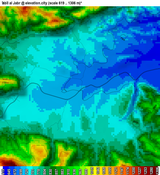
Below is the Elevation map of Ḩabīl al Jabr, which displays elevation range with different colors. Scale of the first map is from 619 to 1306 m (2031 to 4285 ft) with average elevation of 783.3 meters (=2570 ft) [note 1]
These maps also provides idea of topography and contour of this city, they are displayed at different zoom levels. More info about maps, scale and edge coordinates you can find below images.
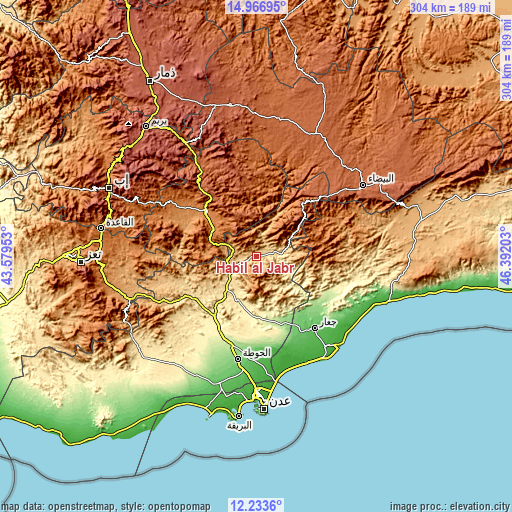
| \ | Map #1 | Topo.Map |
| Scale [m] | 619..1306 m | × |
| Scale [ft] | 2031..4285 ft | × |
| Average | 783.3 m = 2570 ft | × |
| Width | 9.5 km = 5.9 mi | 303.9 km = 188.8 mi |
| Height | 9.5 km = 5.9 mi | 303.9 km = 188.8 mi |
| ↑Max Latitude | 13.646929° | 14.96695° |
| Latitude at center | 13.60422° | 13.60422° |
| ↓Min Latitude | 13.561504° | 12.2336° |
| ← Min Longitude | 44.941835° | 43.57953° |
| Longitude center | 44.98578° | 44.98578° |
| →Max Longitude | 45.029725° | 46.39203° |
Nearby cities:
Cities around Ḩabīl al Jabr sort by population:
• Dhalie elevation 1517 m
29.3 km,  290°
290°
• Al Madu 1999 m
33.4 km,  327°
327°
• Raşad 1657 m
36.3 km,  70°
70°
• Sirār 1490 m
35.6 km,  83°
83°
• As Suwaydā 1529 m
33.3 km,  52°
52°
• Al Ḩusayn 1386 m
31.4 km,  311°
311°
• Dhī Jalāl 1219 m
30.1 km,  274°
274°
• Al ‘Awābil 2058 m
29.1 km, 333°
• Al Jurbah 2260 m
28 km,  41°
41°
• Al Milāḩ 530 m
26.3 km,  221°
221°
• Al Ḩabīlayn 630 m
17.3 km,  237°
237°
• Ḩabīl ar Raydah 944 m
15.2 km, 287°
Multilingual:
 En español:
Ḩabīl al Jabr elevación 697 m.
 En France:
Ḩabīl al Jabr élévation 697 m.
 Auf Deutsch:
Ḩabīl al Jabr höhe über dem Meeresspiegel ist 697 m.

Sources and notes:
- [note 1] Map square and city borders are not equal. Map elevation data is calculated only from area inside that square.
- [src 1] Elevation data from geonames database provided with same terms of usage.
- [src 2] The elevation map of Ḩabīl al Jabr is generated using elevation data from NASA's 3 arcsec (90m) resolution SRTM data.
- [src 3] Base (background) map © OpenStreetMap contributors tiles are generated by Geofabrik and OpenTopoMap.
Copyright & License:
This Ḩabīl al Jabr Elevation Map is licensed under CC BY-SA. You may reuse any part from this page, if you give a proper credit by linking to this URL:
 More info on terms of use page.