Sa'dah elevation
Sa'dah (Şa‘dah), Yemen elevation is 1876 meters and Sa'dah elevation in feet is 6155 ft above sea level [src 1]. Sa'dah is a seat of a first-order administrative division (feature code) with elevation that is 564 meters (1850 ft) bigger than average city elevation in Yemen.
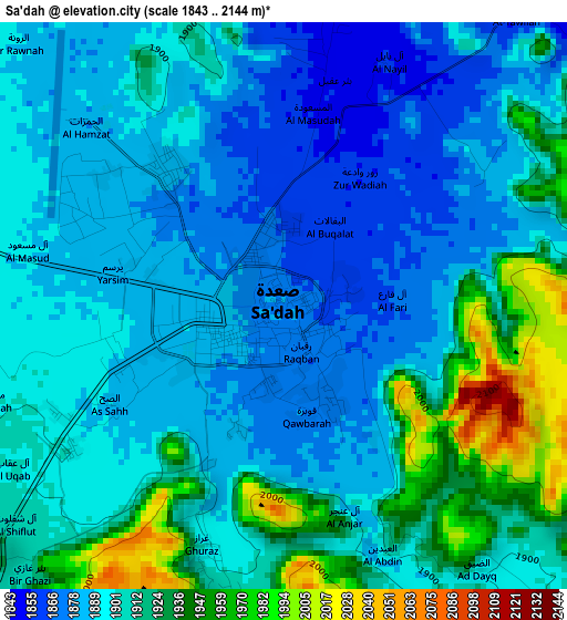
Below is the Elevation map of Sa'dah, which displays elevation range with different colors. Scale of the first map is from 1843 to 2144 m (6047 to 7034 ft) with average elevation of 1903.6 meters (=6245 ft) [note 1]
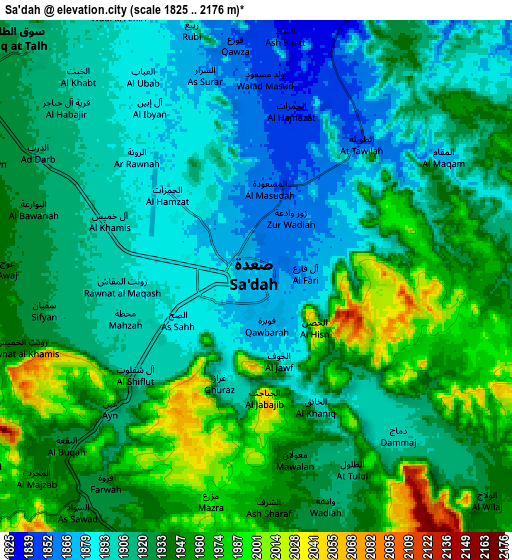
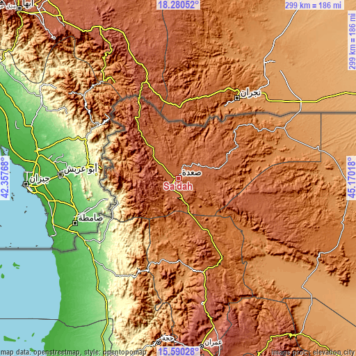
These maps also provides idea of topography and contour of this city, they are displayed at different zoom levels. More info about maps, scale and edge coordinates you can find below images.
| \ | Map #1 | Map #2 | Topo.Map |
| Scale [m] | 1843..2144 m | 1825..2176 m | × |
| Scale [ft] | 6047..7034 ft | 5988..7139 ft | × |
| Average | 1903.6 m = 6245 ft | 1925.6 m = 6318 ft | × |
| Width | 9.35 km = 5.8 mi | 18.7 km = 11.6 mi | 299.1 km = 185.9 mi |
| Height | 9.35 km = 5.8 mi | 18.7 km = 11.6 mi | 299.1 km = 185.9 mi |
| ↑Max Latitude | 16.982244° | 17.024268° | 18.28052° |
| Latitude at center | 16.94021° | 16.94021° | 16.94021° |
| ↓Min Latitude | 16.898167° | 16.856114° | 15.59028° |
| ← Min Longitude | 43.719985° | 43.676039° | 42.35768° |
| Longitude center | 43.76393° | 43.76393° | 43.76393° |
| →Max Longitude | 43.807875° | 43.851821° | 45.17018° |
Nearby cities:
Cities around Sa'dah sort by population:
• Sāqayn elevation 2272 m
26.4 km,  254°
254°
• Ash Shawātī 1992 m
18.2 km,  163°
163°
• Bāqim as Sūq 2117 m
59.2 km,  329°
329°
• Sūq al Khamīs 1863 m
57.2 km,  297°
297°
• Al Hijrah 2449 m
56.4 km,  314°
314°
• Al Malāḩīţ 388 m
55.3 km, 249°
• Al Ḩashwah 1537 m
54.6 km,  93°
93°
• An Naz̧īr 1782 m
53.5 km,  266°
266°
• Al Kharāb 1630 m
45.6 km,  277°
277°
• Ḩaydān 2121 m
39.4 km,  242°
242°
• Kitāf 1953 m
38.1 km,  74°
74°
• Majz 2001 m
24.7 km, 305°
Multilingual:
 En español:
Sa'dah elevación 1876 m.
 En France:
Sa'dah élévation 1876 m.


Sources and notes:
- [note 1] Map square and city borders are not equal. Map elevation data is calculated only from area inside that square.
- [src 1] Elevation data from geonames database provided with same terms of usage.
- [src 2] The elevation map of Sa'dah is generated using elevation data from NASA's 3 arcsec (90m) resolution SRTM data.
- [src 3] Base (background) map © OpenStreetMap contributors tiles are generated by Geofabrik and OpenTopoMap.
Copyright & License:
This Sa'dah Elevation Map is licensed under CC BY-SA. You may reuse any part from this page, if you give a proper credit by linking to this URL:
 More info on terms of use page.