Saḩar elevation
Saḩar (Sanaa, Sanhan), Yemen elevation is 2372 meters and Saḩar elevation in feet is 7782 ft above sea level [src 1]. Saḩar is a populated place (feature code) with elevation that is 1060 meters (3478 ft) bigger than average city elevation in Yemen.
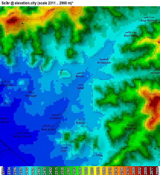
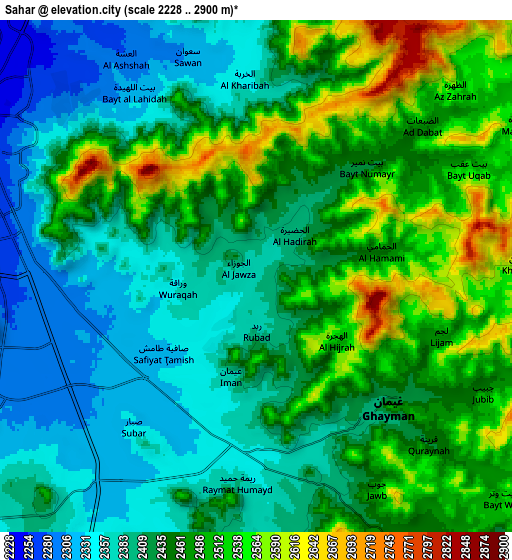
Below is the Elevation map of Saḩar, which displays elevation range with different colors. Scale of the first map is from 2311 to 2900 m (7582 to 9514 ft) with average elevation of 2454.8 meters (=8054 ft) [note 1]
These maps also provides idea of topography and contour of this city, they are displayed at different zoom levels. More info about maps, scale and edge coordinates you can find below images.
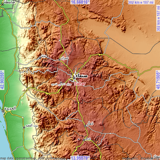
| \ | Map #1 | Map #2 | Topo.Map |
| Scale [m] | 2311..2900 m | 2228..2900 m | × |
| Scale [ft] | 7582..9514 ft | 7310..9514 ft | × |
| Average | 2454.8 m = 8054 ft | 2442.6 m = 8014 ft | × |
| Width | 9.43 km = 5.9 mi | 18.85 km = 11.7 mi | 301.6 km = 187.4 mi |
| Height | 9.43 km = 5.9 mi | 18.85 km = 11.7 mi | 301.6 km = 187.4 mi |
| ↑Max Latitude | 15.35875° | 15.401122° | 16.66816° |
| Latitude at center | 15.31637° | 15.31637° | 15.31637° |
| ↓Min Latitude | 15.273981° | 15.231584° | 13.95579° |
| ← Min Longitude | 44.264855° | 44.220909° | 42.90255° |
| Longitude center | 44.3088° | 44.3088° | 44.3088° |
| →Max Longitude | 44.352745° | 44.396691° | 45.71505° |
Nearby cities:
Cities around Saḩar sort by population:
• Sanaa elevation 2253 m
11.8 km,  291°
291°
• Sayyān 2482 m
16.2 km,  174°
174°
• Jadder Cemetery 2201 m
21.9 km,  320°
320°
• Al Khāniq 2191 m
24.8 km,  326°
326°
• Bayt Marrān 2473 m
43.3 km,  345°
345°
• Al Ḩarjah 1708 m
42.8 km,  63°
63°
• Al Madīd 2091 m
40.5 km,  25°
25°
• Matnah 2791 m
31.3 km,  257°
257°
• Wa‘lān 2449 m
27.6 km,  187°
187°
• Qaryat al Qābil 2250 m
24.5 km,  307°
307°
• Jiḩānah 2249 m
21.1 km,  118°
118°
• Ar Rawḑah 2219 m
15.8 km, 324°
Multilingual:
 En español:
Saḩar elevación 2372 m.
 En France:
Saḩar élévation 2372 m.


Sources and notes:
- [note 1] Map square and city borders are not equal. Map elevation data is calculated only from area inside that square.
- [src 1] Elevation data from geonames database provided with same terms of usage.
- [src 2] The elevation map of Saḩar is generated using elevation data from NASA's 3 arcsec (90m) resolution SRTM data.
- [src 3] Base (background) map © OpenStreetMap contributors tiles are generated by Geofabrik and OpenTopoMap.
Copyright & License:
This Saḩar Elevation Map is licensed under CC BY-SA. You may reuse any part from this page, if you give a proper credit by linking to this URL:
 More info on terms of use page.