Bắc Kạn elevation
Bắc Kạn, Vietnam elevation is 150 meters and Bắc Kạn elevation in feet is 492 ft above sea level [src 1]. Bắc Kạn is a seat of a first-order administrative division (feature code) with elevation that is 22 meters (72 ft) bigger than average city elevation in Vietnam.
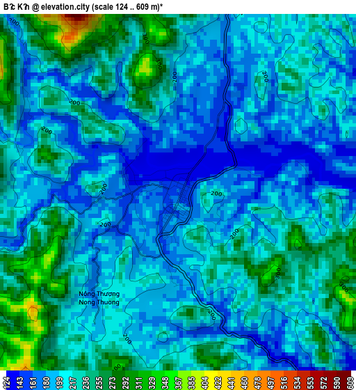
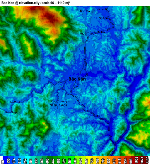
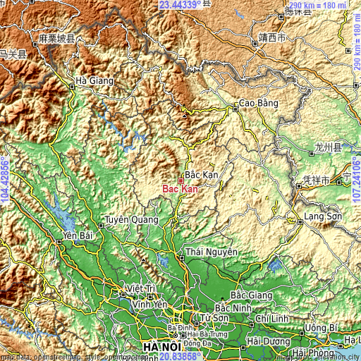
Below is the Elevation map of Bắc Kạn, which displays elevation range with different colors. Scale of the first map is from 124 to 609 m (407 to 1998 ft) with average elevation of 211.5 meters (=694 ft) [note 1]
These maps also provides idea of topography and contour of this city, they are displayed at different zoom levels. More info about maps, scale and edge coordinates you can find below images.
| \ | Map #1 | Map #2 | Topo.Map |
| Scale [m] | 124..609 m | 96..1110 m | × |
| Scale [ft] | 407..1998 ft | 315..3642 ft | × |
| Average | 211.5 m = 694 ft | 303.5 m = 996 ft | × |
| Width | 9.05 km = 5.6 mi | 18.1 km = 11.2 mi | 289.6 km = 179.9 mi |
| Height | 9.05 km = 5.6 mi | 18.1 km = 11.2 mi | 289.6 km = 179.9 mi |
| ↑Max Latitude | 22.187707° | 22.228392° | 23.44339° |
| Latitude at center | 22.14701° | 22.14701° | 22.14701° |
| ↓Min Latitude | 22.106301° | 22.06558° | 20.83858° |
| ← Min Longitude | 105.790865° | 105.746919° | 104.42856° |
| Longitude center | 105.83481° | 105.83481° | 105.83481° |
| →Max Longitude | 105.878755° | 105.922701° | 107.24106° |
Nearby cities:
Cities around Bắc Kạn sort by population:
• Huyện Chiêm Hóa elevation 55 m
57.9 km,  269°
269°
• Thị Trấn Nguyên Bình 471 m
57.4 km,  12°
12°
• Bắc Sơn 396 m
57.1 km,  118°
118°
• Bộc Bố 301 m
54.5 km,  341°
341°
• Thị Trấn Na Hang 64 m
51.7 km,  295°
295°
• Đu 56 m
47.4 km,  196°
196°
• Yến Lạc 252 m
37.1 km,  74°
74°
• Vân Tùng 491 m
35.7 km,  27°
27°
• Chợ Chu 92 m
33.2 km,  216°
216°
• Chợ Mới 63 m
30 km,  192°
192°
• Bằng Lũng 351 m
24.7 km, 272°
• Phủ Thông 186 m
14.8 km,  18°
18°
Multilingual:
 En español:
Bắc Kạn elevación 150 m.
 En France:
Bắc Kạn élévation 150 m.


Sources and notes:
- [note 1] Map square and city borders are not equal. Map elevation data is calculated only from area inside that square.
- [src 1] Elevation data from geonames database provided with same terms of usage.
- [src 2] The elevation map of Bắc Kạn is generated using elevation data from NASA's 3 arcsec (90m) resolution SRTM data.
- [src 3] Base (background) map © OpenStreetMap contributors tiles are generated by Geofabrik and OpenTopoMap.
Copyright & License:
This Bắc Kạn Elevation Map is licensed under CC BY-SA. You may reuse any part from this page, if you give a proper credit by linking to this URL:
 More info on terms of use page.