Cà Mau elevation
Cà Mau, Vietnam elevation is 5 meters and Cà Mau elevation in feet is 16 ft above sea level [src 1]. Cà Mau is a seat of a first-order administrative division (feature code) with elevation that is 123 meters (404 ft) smaller than average city elevation in Vietnam.
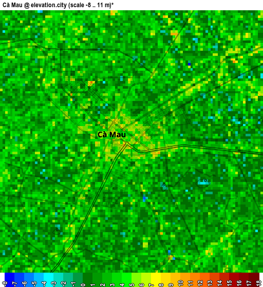
Below is the Elevation map of Cà Mau, which displays elevation range with different colors. Scale of the first map is from -8 to 11 m (-26 to 36 ft) with average elevation of 2.1 meters (=7 ft) [note 1]
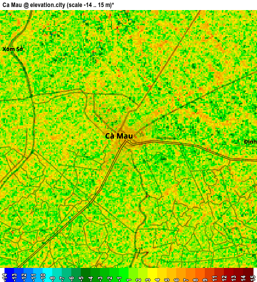
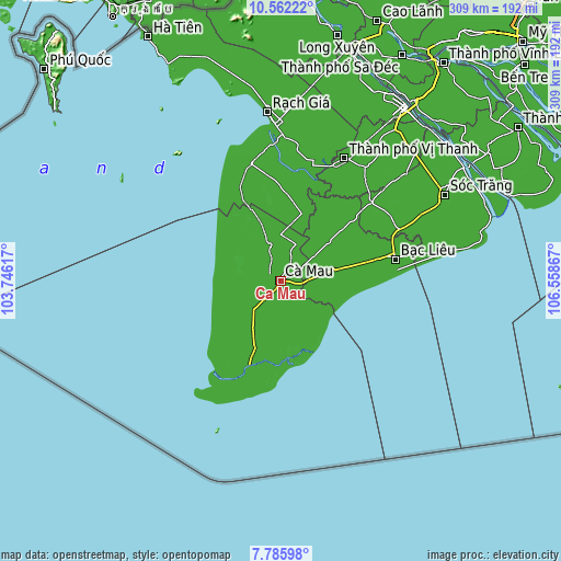
These maps also provides idea of topography and contour of this city, they are displayed at different zoom levels. More info about maps, scale and edge coordinates you can find below images.
| \ | Map #1 | Map #2 | Topo.Map |
| Scale [m] | -8..11 m | -14..15 m | × |
| Scale [ft] | -26..36 ft | -46..49 ft | × |
| Average | 2.1 m = 7 ft | 2 m = 7 ft | × |
| Width | 9.65 km = 6 mi | 19.29 km = 12 mi | 308.7 km = 191.8 mi |
| Height | 9.65 km = 6 mi | 19.29 km = 12 mi | 308.7 km = 191.8 mi |
| ↑Max Latitude | 9.2202° | 9.263575° | 10.56222° |
| Latitude at center | 9.17682° | 9.17682° | 9.17682° |
| ↓Min Latitude | 9.133435° | 9.090044° | 7.78598° |
| ← Min Longitude | 105.108475° | 105.064529° | 103.74617° |
| Longitude center | 105.15242° | 105.15242° | 105.15242° |
| →Max Longitude | 105.196365° | 105.240311° | 106.55867° |
Nearby cities:
Cities around Cà Mau sort by population:
• Thứ Mười Một elevation 1 m
53.3 km,  334°
334°
• Cai Doi Vam 2 m
51.6 km,  226°
226°
• Năm Căn 5 m
49.7 km,  200°
200°
• Thị Trấn Phước Long 5 m
44.7 km,  49°
49°
• Vĩnh Thuận 3 m
38.6 km,  17°
17°
• Thị Trấn Giá Rai 4 m
33.9 km,  78°
78°
• Thị Trấn Gành Hào 2 m
33.6 km,  118°
118°
• U Minh 2 m
32.8 km,  323°
323°
• Cái Nước 2 m
30.2 km,  210°
210°
• Trần Văn Thời 1 m
22 km,  239°
239°
• Đầm Dơi 2 m
21.1 km,  166°
166°
• Thới Bình 4 m
20.7 km,  343°
343°
Multilingual:
 En español:
Cà Mau elevación 5 m.
 En France:
Cà Mau élévation 5 m.


Sources and notes:
- [note 1] Map square and city borders are not equal. Map elevation data is calculated only from area inside that square.
- [src 1] Elevation data from geonames database provided with same terms of usage.
- [src 2] The elevation map of Cà Mau is generated using elevation data from NASA's 3 arcsec (90m) resolution SRTM data.
- [src 3] Base (background) map © OpenStreetMap contributors tiles are generated by Geofabrik and OpenTopoMap.
Copyright & License:
This Cà Mau Elevation Map is licensed under CC BY-SA. You may reuse any part from this page, if you give a proper credit by linking to this URL:
 More info on terms of use page.