Cao Bằng elevation
Cao Bằng, Vietnam elevation is 197 meters and Cao Bằng elevation in feet is 646 ft above sea level [src 1]. Cao Bằng is a seat of a first-order administrative division (feature code) with elevation that is 69 meters (226 ft) bigger than average city elevation in Vietnam.
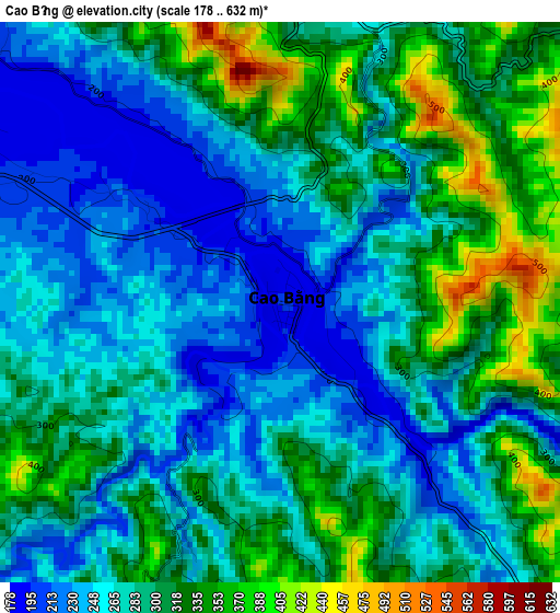
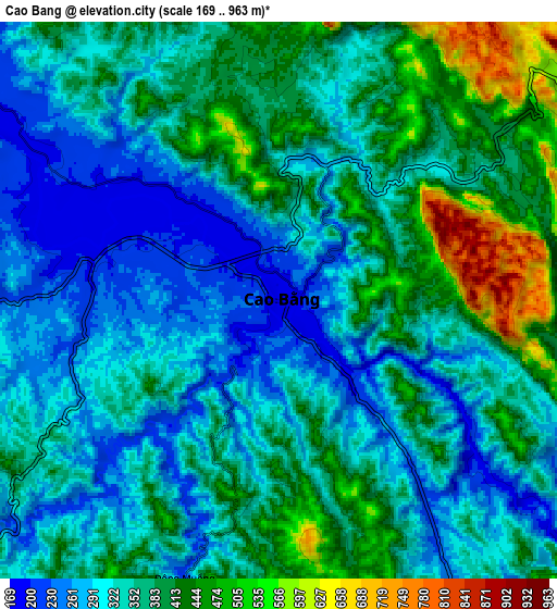
Below is the Elevation map of Cao Bằng, which displays elevation range with different colors. Scale of the first map is from 178 to 632 m (584 to 2073 ft) with average elevation of 287 meters (=942 ft) [note 1]
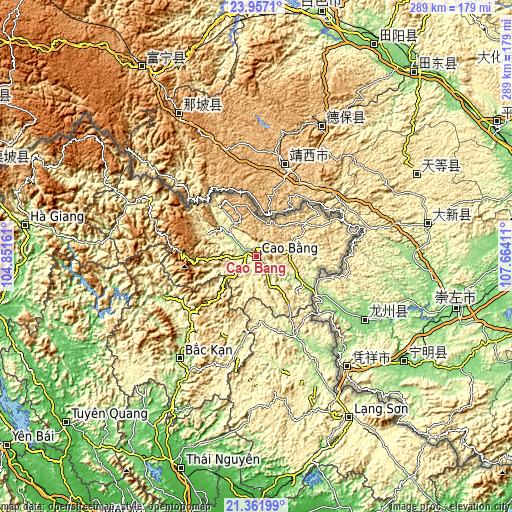
These maps also provides idea of topography and contour of this city, they are displayed at different zoom levels. More info about maps, scale and edge coordinates you can find below images.
| \ | Map #1 | Map #2 | Topo.Map |
| Scale [m] | 178..632 m | 169..963 m | × |
| Scale [ft] | 584..2073 ft | 554..3159 ft | × |
| Average | 287 m = 942 ft | 354.1 m = 1162 ft | × |
| Width | 9.02 km = 5.6 mi | 18.04 km = 11.2 mi | 288.5 km = 179.3 mi |
| Height | 9.02 km = 5.6 mi | 18.04 km = 11.2 mi | 288.6 km = 179.3 mi |
| ↑Max Latitude | 22.706225° | 22.746759° | 23.9571° |
| Latitude at center | 22.66568° | 22.66568° | 22.66568° |
| ↓Min Latitude | 22.625123° | 22.584553° | 21.36199° |
| ← Min Longitude | 106.213915° | 106.169969° | 104.85161° |
| Longitude center | 106.25786° | 106.25786° | 106.25786° |
| →Max Longitude | 106.301805° | 106.345751° | 107.66411° |
Nearby cities:
Cities around Cao Bằng sort by population:
• Yến Lạc elevation 252 m
48.3 km,  189°
189°
• Thị Trấn Thanh Nhật 382 m
42.4 km,  86°
86°
• Vân Tùng 491 m
37.4 km,  225°
225°
• Thị Trấn Tà Lùng 157 m
36.8 km,  120°
120°
• Thị Trấn Trùng Khánh 530 m
33.2 km,  55°
55°
• Thị Trấn Xuân Hoà 275 m
32.2 km,  324°
324°
• Thị Trấn Đông Khê 435 m
31.8 km,  145°
145°
• Thị Trấn Thông Nông 261 m
31.1 km,  295°
295°
• Thị Trấn Nguyên Bình 471 m
30.6 km,  266°
266°
• Thị Trấn Hùng Quốc 654 m
19.4 km,  20°
20°
• Thị Trấn Quảng Uyên 458 m
19.2 km,  80°
80°
• Thị Trấn Nước Hai 204 m
13.5 km,  306°
306°
Multilingual:
 En español:
Cao Bằng elevación 197 m.
 En France:
Cao Bằng élévation 197 m.
 Auf Deutsch:
Cao Bằng höhe über dem Meeresspiegel ist 197 m.

Sources and notes:
- [note 1] Map square and city borders are not equal. Map elevation data is calculated only from area inside that square.
- [src 1] Elevation data from geonames database provided with same terms of usage.
- [src 2] The elevation map of Cao Bằng is generated using elevation data from NASA's 3 arcsec (90m) resolution SRTM data.
- [src 3] Base (background) map © OpenStreetMap contributors tiles are generated by Geofabrik and OpenTopoMap.
Copyright & License:
This Cao Bằng Elevation Map is licensed under CC BY-SA. You may reuse any part from this page, if you give a proper credit by linking to this URL:
 More info on terms of use page.