Ðà Lạt elevation
Ðà Lạt (Lâm Đồng), Vietnam elevation is 1483 meters and Ðà Lạt elevation in feet is 4865 ft above sea level [src 1]. Ðà Lạt is a seat of a first-order administrative division (feature code) with elevation that is 1355 meters (4446 ft) bigger than average city elevation in Vietnam.
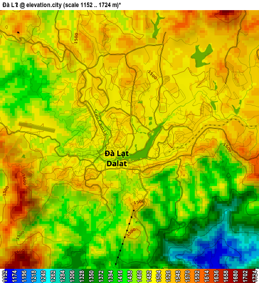
Below is the Elevation map of Ðà Lạt, which displays elevation range with different colors. Scale of the first map is from 1152 to 1724 m (3780 to 5656 ft) with average elevation of 1475.6 meters (=4841 ft) [note 1]
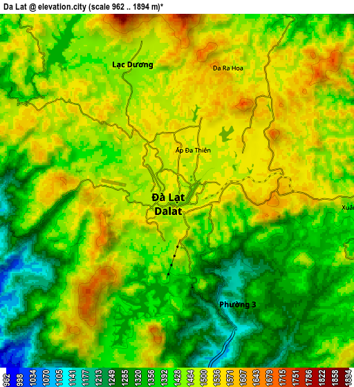
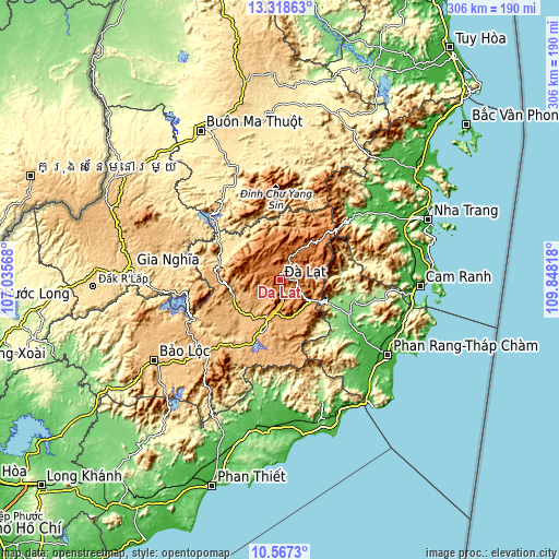
These maps also provides idea of topography and contour of this city, they are displayed at different zoom levels. More info about maps, scale and edge coordinates you can find below images.
| \ | Map #1 | Map #2 | Topo.Map |
| Scale [m] | 1152..1724 m | 962..1894 m | × |
| Scale [ft] | 3780..5656 ft | 3156..6214 ft | × |
| Average | 1475.6 m = 4841 ft | 1435.3 m = 4709 ft | × |
| Width | 9.56 km = 5.9 mi | 19.12 km = 11.9 mi | 305.9 km = 190.1 mi |
| Height | 9.56 km = 5.9 mi | 19.12 km = 11.9 mi | 305.9 km = 190.1 mi |
| ↑Max Latitude | 11.98945° | 12.032433° | 13.31863° |
| Latitude at center | 11.94646° | 11.94646° | 11.94646° |
| ↓Min Latitude | 11.903463° | 11.860459° | 10.5673° |
| ← Min Longitude | 108.397985° | 108.354039° | 107.03568° |
| Longitude center | 108.44193° | 108.44193° | 108.44193° |
| →Max Longitude | 108.485875° | 108.529821° | 109.84818° |
Nearby cities:
Cities around Ðà Lạt sort by population:
• Đưc Trọng elevation 939 m
24.6 km,  197°
197°
• Đinh Văn 848 m
28 km,  230°
230°
• Phước Dân 12 m
70.7 km,  131°
131°
• Krông Kmar 464 m
63.2 km,  349°
349°
• Khánh Vĩnh 28 m
62.7 km,  53°
53°
• Lắk 429 m
59.1 km,  330°
330°
• Di Linh 978 m
56.8 km,  224°
224°
• Tô Hạp 382 m
55.5 km,  83°
83°
• Bác Ái 136 m
51.5 km,  103°
103°
• Tân Sơn 122 m
41.9 km,  117°
117°
• Thạnh Mỹ 1014 m
21.3 km,  164°
164°
• Lạc Dương 1463 m
6.9 km,  338°
338°
Multilingual:
 En español:
Ðà Lạt elevación 1483 m.
 En France:
Ðà Lạt élévation 1483 m.


Sources and notes:
- [note 1] Map square and city borders are not equal. Map elevation data is calculated only from area inside that square.
- [src 1] Elevation data from geonames database provided with same terms of usage.
- [src 2] The elevation map of Ðà Lạt is generated using elevation data from NASA's 3 arcsec (90m) resolution SRTM data.
- [src 3] Base (background) map © OpenStreetMap contributors tiles are generated by Geofabrik and OpenTopoMap.
Copyright & License:
This Ðà Lạt Elevation Map is licensed under CC BY-SA. You may reuse any part from this page, if you give a proper credit by linking to this URL:
 More info on terms of use page.