Dien Bien Phu elevation
Dien Bien Phu (Ðiện Biên), Vietnam elevation is 485 meters and Dien Bien Phu elevation in feet is 1591 ft above sea level [src 1]. Dien Bien Phu is a seat of a first-order administrative division (feature code) with elevation that is 357 meters (1171 ft) bigger than average city elevation in Vietnam.
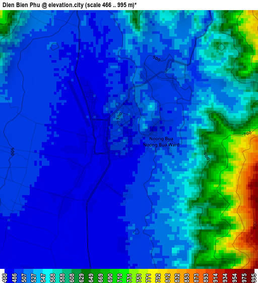
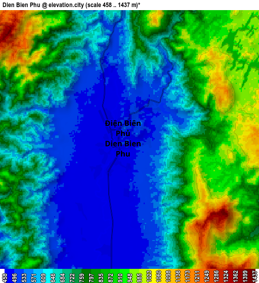
Below is the Elevation map of Dien Bien Phu, which displays elevation range with different colors. Scale of the first map is from 466 to 995 m (1529 to 3264 ft) with average elevation of 541 meters (=1775 ft) [note 1]
These maps also provides idea of topography and contour of this city, they are displayed at different zoom levels. More info about maps, scale and edge coordinates you can find below images.
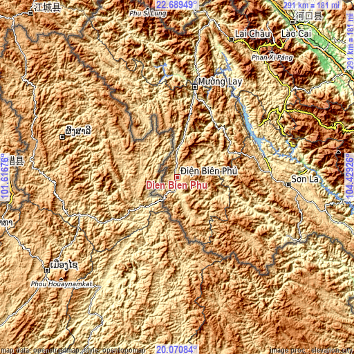
| \ | Map #1 | Map #2 | Topo.Map |
| Scale [m] | 466..995 m | 458..1437 m | × |
| Scale [ft] | 1529..3264 ft | 1503..4715 ft | × |
| Average | 541 m = 1775 ft | 721.1 m = 2366 ft | × |
| Width | 9.1 km = 5.7 mi | 18.2 km = 11.3 mi | 291.2 km = 180.9 mi |
| Height | 9.1 km = 5.7 mi | 18.2 km = 11.3 mi | 291.2 km = 180.9 mi |
| ↑Max Latitude | 21.426934° | 21.467836° | 22.68949° |
| Latitude at center | 21.38602° | 21.38602° | 21.38602° |
| ↓Min Latitude | 21.345095° | 21.304158° | 20.07084° |
| ← Min Longitude | 102.979065° | 102.935119° | 101.61676° |
| Longitude center | 103.02301° | 103.02301° | 103.02301° |
| →Max Longitude | 103.066955° | 103.110901° | 104.42926° |
Nearby cities:
Cities around Dien Bien Phu sort by population:
• Sơn La elevation 608 m
93 km,  94°
94°
• Mường Nhé 545 m
107 km,  326°
326°
• Ít Ong 206 m
104.9 km,  81°
81°
• Sông Mã 336 m
84.1 km,  116°
116°
• Mường Chiên 160 m
75.7 km,  47°
47°
• Thị Trấn Thuận Châu 594 m
69.3 km, 85°
• Thị Trấn Tủa Chùa 862 m
62 km,  32°
32°
• Thị Trấn Tuần Giáo 568 m
47.1 km,  61°
61°
• Mường Chà 523 m
42.5 km,  10°
10°
• Mường Ảng 573 m
25.5 km, 54°
• Điện Biên Đông 833 m
22.7 km, 115°
• Thị Trấn Điện Biên 523 m
14.1 km,  175°
175°
Multilingual:
 En español:
Điện Biên Phủ elevación 485 m.
 En France:
Diên Biên Phu, Ðiện Biên Phủ élévation 485 m.
 Auf Deutsch:
Điện Biên Phủ höhe über dem Meeresspiegel ist 485 m.

Sources and notes:
- [note 1] Map square and city borders are not equal. Map elevation data is calculated only from area inside that square.
- [src 1] Elevation data from geonames database provided with same terms of usage.
- [src 2] The elevation map of Dien Bien Phu is generated using elevation data from NASA's 3 arcsec (90m) resolution SRTM data.
- [src 3] Base (background) map © OpenStreetMap contributors tiles are generated by Geofabrik and OpenTopoMap.
Copyright & License:
This Dien Bien Phu Elevation Map is licensed under CC BY-SA. You may reuse any part from this page, if you give a proper credit by linking to this URL:
 More info on terms of use page.