Kwang Binh elevation
Kwang Binh (Quảng Bình), Vietnam elevation is 9 meters and Kwang Binh elevation in feet is 30 ft above sea level [src 1]. Kwang Binh is a seat of a first-order administrative division (feature code) with elevation that is 119 meters (390 ft) smaller than average city elevation in Vietnam.
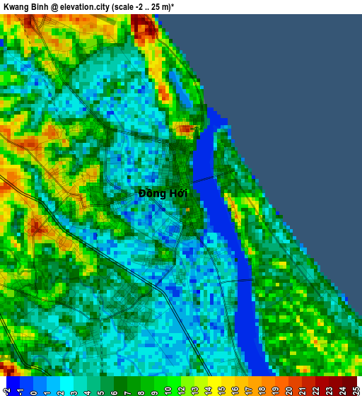
Below is the Elevation map of Kwang Binh, which displays elevation range with different colors. Scale of the first map is from -2 to 25 m (-7 to 82 ft) with average elevation of 6.9 meters (=23 ft) [note 1]
These maps also provides idea of topography and contour of this city, they are displayed at different zoom levels. More info about maps, scale and edge coordinates you can find below images.
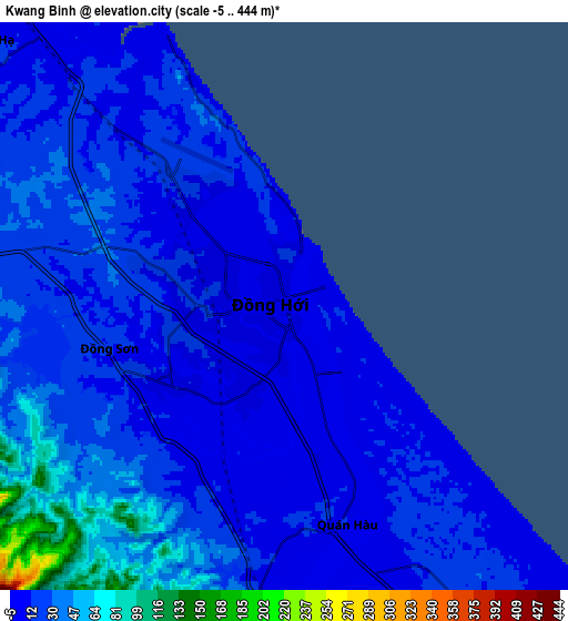

| \ | Map #1 | Map #2 | Topo.Map |
| Scale [m] | -2..25 m | -5..444 m | × |
| Scale [ft] | -7..82 ft | -16..1457 ft | × |
| Average | 6.9 m = 23 ft | 22.8 m = 75 ft | × |
| Width | 9.32 km = 5.8 mi | 18.64 km = 11.6 mi | 298.3 km = 185.4 mi |
| Height | 9.32 km = 5.8 mi | 18.64 km = 11.6 mi | 298.3 km = 185.4 mi |
| ↑Max Latitude | 17.510764° | 17.552668° | 18.80519° |
| Latitude at center | 17.46885° | 17.46885° | 17.46885° |
| ↓Min Latitude | 17.426927° | 17.384994° | 16.12263° |
| ← Min Longitude | 106.578315° | 106.534369° | 105.21601° |
| Longitude center | 106.62226° | 106.62226° | 106.62226° |
| →Max Longitude | 106.666205° | 106.710151° | 108.02851° |
Nearby cities:
Cities around Kwang Binh sort by population:
• Ðông Hà elevation 21 m
88.6 km,  145°
145°
• Krông Klang 35 m
91.2 km,  161°
161°
• Cam Lộ 13 m
83.4 km, 151°
• Oui Dat 186 m
78.5 km,  298°
298°
• Đồng Lê 33 m
78.3 km,  306°
306°
• Gio Linh 7 m
77.9 km,  140°
140°
• Kỳ Anh 21 m
74.4 km,  332°
332°
• Hồ Xá 11 m
60.3 km, 137°
• Ba Đồn 8 m
38 km, 326°
• Kiến Giang 7 m
32.6 km, 146°
• Hoàn Lão 10 m
15.9 km,  323°
323°
• Quán Hàu 13 m
7.4 km, 164°
Multilingual:
 En español:
Dong Hoi elevación 9 m.
 En France:
Đồng Hới élévation 9 m.


Sources and notes:
- [note 1] Map square and city borders are not equal. Map elevation data is calculated only from area inside that square.
- [src 1] Elevation data from geonames database provided with same terms of usage.
- [src 2] The elevation map of Kwang Binh is generated using elevation data from NASA's 3 arcsec (90m) resolution SRTM data.
- [src 3] Base (background) map © OpenStreetMap contributors tiles are generated by Geofabrik and OpenTopoMap.
Copyright & License:
This Kwang Binh Elevation Map is licensed under CC BY-SA. You may reuse any part from this page, if you give a proper credit by linking to this URL:
 More info on terms of use page.