Thị Trấn Đồng Văn elevation
Thị Trấn Đồng Văn (Hà Giang), Vietnam elevation is 1068 meters and Thị Trấn Đồng Văn elevation in feet is 3504 ft above sea level [src 1]. Thị Trấn Đồng Văn is a seat of a second-order administrative division (feature code) with elevation that is 940 meters (3084 ft) bigger than average city elevation in Vietnam.
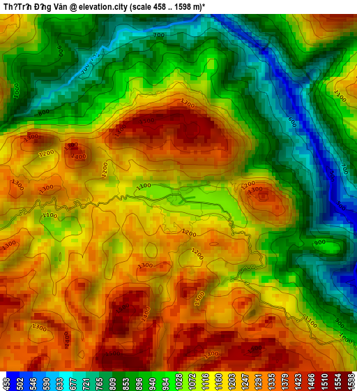
Below is the Elevation map of Thị Trấn Đồng Văn, which displays elevation range with different colors. Scale of the first map is from 458 to 1598 m (1503 to 5243 ft) with average elevation of 1095 meters (=3593 ft) [note 1]
These maps also provides idea of topography and contour of this city, they are displayed at different zoom levels. More info about maps, scale and edge coordinates you can find below images.
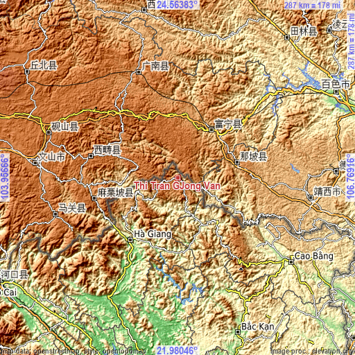
| \ | Map #1 | Topo.Map |
| Scale [m] | 458..1598 m | × |
| Scale [ft] | 1503..5243 ft | × |
| Average | 1095 m = 3593 ft | × |
| Width | 8.98 km = 5.6 mi | 287.2 km = 178.5 mi |
| Height | 8.98 km = 5.6 mi | 287.3 km = 178.5 mi |
| ↑Max Latitude | 23.318772° | 24.56383° |
| Latitude at center | 23.27841° | 23.27841° |
| ↓Min Latitude | 23.238036° | 21.98046° |
| ← Min Longitude | 105.318965° | 103.95666° |
| Longitude center | 105.36291° | 105.36291° |
| →Max Longitude | 105.406855° | 106.76916° |
Nearby cities:
Cities around Thị Trấn Đồng Văn sort by population:
• Hà Giang elevation 107 m
63.8 km,  217°
217°
• Thị Trấn Việt Lâm 79 m
83.6 km,  209°
209°
• Bộc Bố 301 m
80.4 km,  157°
157°
• Thị Trấn Vị Xuyên 93 m
78.3 km, 209°
• Yên Phú 133 m
60.7 km,  179°
179°
• Pác Miầu 147 m
51.6 km,  165°
165°
• Thị Trấn Bảo Lạc 212 m
48.9 km,  138°
138°
• Tân Việt 344 m
47.1 km, 167°
• Thị Trấn Tam Sơn 874 m
44.8 km,  238°
238°
• Lũng Hồ 646 m
35 km,  201°
201°
• Thị Trấn Yên Minh 434 m
28.8 km,  231°
231°
• Thị Trấn Mèo Vạc 989 m
13.6 km, 159°
Multilingual:
 En español:
Thị Trấn Đồng Văn elevación 1068 m.
 En France:
Thị Trấn Đồng Văn élévation 1068 m.
 Auf Deutsch:
Thị Trấn Đồng Văn höhe über dem Meeresspiegel ist 1068 m.
 На русском:
Thị Trấn Đồng Văn высота над уровнем моря 1068 м
Sources and notes:
- [note 1] Map square and city borders are not equal. Map elevation data is calculated only from area inside that square.
- [src 1] Elevation data from geonames database provided with same terms of usage.
- [src 2] The elevation map of Thị Trấn Đồng Văn is generated using elevation data from NASA's 3 arcsec (90m) resolution SRTM data.
- [src 3] Base (background) map © OpenStreetMap contributors tiles are generated by Geofabrik and OpenTopoMap.
Copyright & License:
This Thị Trấn Đồng Văn Elevation Map is licensed under CC BY-SA. You may reuse any part from this page, if you give a proper credit by linking to this URL:
 More info on terms of use page.